Fitxategi:The Roman Empire ca. 400 AD.svg

SVG fitxategi honen PNG aurreikuspenaren tamaina: 800 × 492 pixel. Bestelako bereizmenak: 320 × 197 pixel | 640 × 394 pixel | 1.024 × 630 pixel | 1.280 × 787 pixel | 2.560 × 1.575 pixel | 3.170 × 1.950 pixel.
Bereizmen handikoa (SVG fitxategia, nominaldi 3.170 × 1.950 pixel, fitxategiaren tamaina: 6,53 MB)
Fitxategi hau Wikimedia Commonsekoa da. Hango deskribapen orriko informazioa behean duzu. |
Laburpena
| Deskribapena |
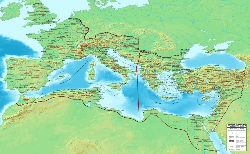
English: Map of the Roman Empire ca. 400 AD, showing the administrative division into dioceses and provinces, as well as the major cities. The demarcation between Eastern and Western Empires is noted in red. |
| Data | |
| Jatorria |
Base map found at User:Koba-chan/Topographic map, otherwise self-made. Data based on maps in atlases (Westermann's Atlas zur Weltgeschichte, the Academy of Athens' History of the Greek Nation, etc.) and the internet and on contemporary sources, primarily the Notitia Dignitatum and the Synecdemus. |
| Egilea | Constantine Plakidas |
| Beste bertsioak | File:The Roman Empire ca. 400 AD-zh.svg |
Lizentzia
Nik, lan honen egileak, argitaratzen dut ondorengo lizentzia pean:
This file is licensed under the Creative Commons Attribution-Share Alike 4.0 International license.
- Askea zara:
- partekatzeko – lana kopiatzeko, banatzeko eta bidaltzeko
- birnahasteko – lana moldatzeko
- Ondorengo baldintzen pean:
- eskuduntza – Egiletza behar bezala aitortu behar duzu, lizentzia ikusteko esteka gehitu, eta ea aldaketak egin diren aipatu. Era egokian egin behar duzu hori guztia, baina inola ere ez egileak zure lana edo zure erabilera babesten duela irudikatuz.
- berdin partekatu – Lan honetan oinarrituta edo aldatuta berria eraikitzen baduzu, emaitza lana hau bezalako lizentzia batekin argitaratu behar duzu.
| Annotations | This image is annotated: View the annotations at Commons |
Fitxategiaren historia
Data/orduan klik egin fitxategiak orduan zuen itxura ikusteko.
| Data/Ordua | Iruditxoa | Neurriak | Erabiltzailea | Iruzkina | |
|---|---|---|---|---|---|
| oraingoa | 00:00, 16 urria 2019 | | 3.170 × 1.950 (6,53 MB) | Cplakidas | User created page with UploadWizard |
Irudira dakarten loturak
Hurrengo orrialdeek dute fitxategi honetarako lotura:
Fitxategiaren erabilera orokorra
Hurrengo beste wikiek fitxategi hau darabilte:
- en.wikipedia.org proiektuan duen erabilera
- fr.wikipedia.org proiektuan duen erabilera
- it.wikipedia.org proiektuan duen erabilera