Fitxategi:Tamis banat1751 1778.png
Aurreikuspen honen neurria: 621 × 600 pixel. Bestelako bereizmenak: 248 × 240 pixel | 497 × 480 pixel | 996 × 962 pixel.
Bereizmen handikoa ((996 × 962 pixel, fitxategiaren tamaina: 112 KB, MIME mota: image/png))
Fitxategi hau Wikimedia Commonsekoa da. Hango deskribapen orriko informazioa behean duzu. |
Laburpena
| Deskribapena |
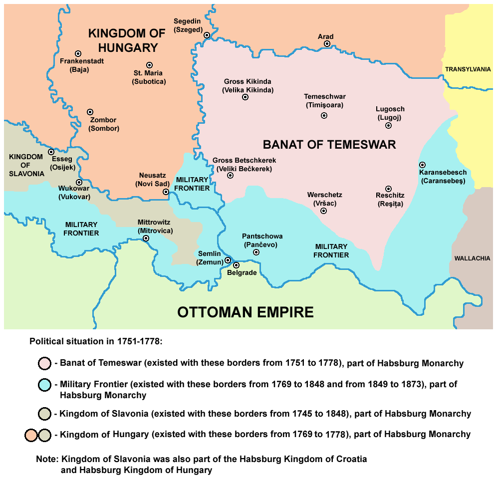
English: map of the Banat of Temeswar, Kingdom of Slavonia and Military Frontier in 1751-1778.
Српски / srpski: мапа Тамишког Баната, Краљевине Славоније и војне границе (1751-1778. године) |
| Data | 2009ko abuztuaren 1ea (Jatorrizko igoera-data) |
| Jatorria | No machine-readable source provided. Own work assumed (based on copyright claims). |
| Egilea | No machine-readable author provided. PANONIAN assumed (based on copyright claims). |
References
- The Times History of Europe, Times Books, 2002.
- Denis Šehić - Demir Šehić, Istorijski atlas Sveta, Beograd, 2007.
- Milan Tutorov, Banatska rapsodija - istorika Zrenjanina i Banata, Novi Sad, 2001.
- Peter Rokai - Zoltan Đere - Tibor Pal - Aleksandar Kasaš, Istorija Mađara, Beograd, 2002.
- Dr Dušan J. Popović, Srbi u Vojvodini, knjiga 2, Novi Sad, 1990.
- Dr Milenko Palić, Srbi u Mađarskoj - Ugarskoj do 1918, Novi Sad, 1995.
- J. H. Šviker, Politička istorija Srba u Ugarskoj, Novi Sad - Beograd, 1998.
- Fridrih Vilhelm fon Taube, Istorijski i geografski opis Kraljevine Slavonije i Vojvodstva Srema, Novi Sad, 1998.
- Miodrag Milin, Vekovima zajedno (Iz istorije srpsko-rumunskih odnosa), Temišvar, 1995.
- Suzana Milovanović, Potiska i pomoriška vojna granica (1702-1751), Novi Sad, 2003.
- Dimitrije Boarov, Politička istorija Vojvodine, Novi Sad, 2001.
- Drago Njegovan, Prisajedinjenje Vojvodine Srbiji, Novi Sad, 2004.
Lizentzia
self made map by user:PANONIAN
| Nik, lan honen egile eskubideen jabeak, lan hau domeinu publikoan jartzen dut. Mundu osoan du eragina honek. Estatu batzuetan beharbada hori ez da legez posible izango. Halakoetan: Edonori ematen diot lan hau edozertarako erabiltzeko eskubidea, inolako baldintzarik gabe, legeak nahitaez ezarritako baldintzak izan ezik. |
Fitxategiaren historia
Data/orduan klik egin fitxategiak orduan zuen itxura ikusteko.
| Data/Ordua | Iruditxoa | Neurriak | Erabiltzailea | Iruzkina | |
|---|---|---|---|---|---|
| oraingoa | 13:55, 24 ekaina 2014 | | 996 × 962 (112 KB) | PANONIAN | aesthetics |
| 15:18, 14 otsaila 2013 |  | 996 × 962 (114 KB) | PANONIAN | {{Information |Description ={{en|1=easthetics}} |Source =easthetics |Author =easthetics |Date = |Permission = |other_versions = }} | |
| 21:51, 30 iraila 2011 |  | 998 × 962 (114 KB) | PANONIAN | correction | |
| 16:49, 30 iraila 2011 |  | 998 × 962 (115 KB) | PANONIAN | some corrections | |
| 13:27, 1 abuztua 2009 |  | 998 × 962 (115 KB) | PANONIAN | ==Description== * '''English''': map of the Banat of Temeswar, Kingdom of Slavonia and Military Frontier in 1751-1778. * '''Serbian''': мапа Тамишког Баната, Краљевине Славоније и војне границе (1751-1778. |
Irudira dakarten loturak
Hurrengo orrialdeek dute fitxategi honetarako lotura:
Fitxategiaren erabilera orokorra
Hurrengo beste wikiek fitxategi hau darabilte:
- ca.wikipedia.org proiektuan duen erabilera
- de.wikipedia.org proiektuan duen erabilera
- el.wikipedia.org proiektuan duen erabilera
- en.wikipedia.org proiektuan duen erabilera
- es.wikipedia.org proiektuan duen erabilera
- et.wikipedia.org proiektuan duen erabilera
- fa.wikipedia.org proiektuan duen erabilera
- gl.wikipedia.org proiektuan duen erabilera
- he.wikipedia.org proiektuan duen erabilera
- it.wikipedia.org proiektuan duen erabilera
- pt.wikipedia.org proiektuan duen erabilera
- ro.wikipedia.org proiektuan duen erabilera
- sh.wikipedia.org proiektuan duen erabilera