Fitxategi:South Africa 2011 population density map (hex cells).svg

Bereizmen handikoa(SVG fitxategia, nominaldi 807 × 711 pixel, fitxategiaren tamaina: 1,41 MB)

Fitxategi hau Wikimedia Commonsekoa da. Hango deskribapen orriko informazioa behean duzu.
Commons gordailu bat da, lizentzia askea duten multimedia fitxategiena. Lagun dezakezu.

Fitxategi hau Wikimedia Commonsekoa da

Laburpena

Deskribapena
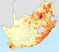
English: Population density map of South Africa, based on the 2011 census, using data aggregated to regular 50km2 hexagonal cells.
 
<1 inhabitant/km²
 
1–3 inhabitants/km²
 
3–10 inhabitants/km²
 
10–30 inhabitants/km²
 
30–100 inhabitants/km²
 
100–300 inhabitants/km²
 
300–1000 inhabitants/km²
 
1000–3000 inhabitants/km²
 
>3000 inhabitants/km²
Projection is Albers Equal-Area Conic, with standard parallels at 24° S and 33° S and central meridian at 25° E.
Deutsch: Bevölkerungsdichte Südafrikas im Jahr 2011:
 
<1 Einwohner/km²
 
1–3 Einwohner/km²
 
3–10 Einwohner/km²
 
10–30 Einwohner/km²
 
30–100 Einwohner/km²
 
100–300 Einwohner/km²
 
300–1000 Einwohner/km²
 
1000–3000 Einwohner/km²
 
>3000 Einwohner/km²
Data
Jatorria Statistics South Africa's Census 2011 (Small Area Layer) is the source of the basic population data. The map results from my own processing of the data.
Egilea Htonl
Beste bertsioak South Africa 2011 population density map.svg

Lizentzia

The following license applies to the population data on which the map is based:

© The copyright holder of this file, Stats SA, allows anyone to use it for any purpose, provided that the copyright holder is properly attributed. Redistribution, derivative work, commercial use, and all other use is permitted.
Aitortu:
"the user acknowledges Stats SA as the source of the basic data wherever they process, apply, utilise, publish or distribute the data, and also that they specify that the relevant application and analysis (where applicable) result from their own processing of the data" [1]

The following tag applies to the map itself:

Public domain Nik, lan honen egile eskubideen jabeak, lan hau domeinu publikoan jartzen dut. Mundu osoan du eragina honek.
Estatu batzuetan beharbada hori ez da legez posible izango. Halakoetan:
Edonori ematen diot lan hau edozertarako erabiltzeko eskubidea, inolako baldintzarik gabe, legeak nahitaez ezarritako baldintzak izan ezik.

Irudi-oineko testuak

Add a one-line explanation of what this file represents

Fitxategi honetan agertzen diren itemak

honako hau irudikatzen du

10 martxoa 2021

media type ingelesa

image/svg+xml

Fitxategiaren historia

Data/orduan klik egin fitxategiak orduan zuen itxura ikusteko.

Data/OrduaIruditxoaNeurriakErabiltzaileaIruzkina
oraingoa17:43, 10 martxoa 202117:43, 10 martxoa 2021 bertsioaren iruditxoa807 × 711 (1,41 MB)Htonl== {{int:filedesc}} == {{Information |Description={{en|1=Population density map of South Africa, based on the 2011 census, using data aggregated to regular 50km<sup>2</sup> hexagonal cells. {{legend|#ffffcc|<1 inhabitant/km²}} {{legend|#ffeda0|1–3 inhabitants/km²}} {{legend|#fed976|3–10 inhabitants/km²}} {{legend|#feb24c|10–30 inhabitants/km²}} {{legend|#fd8d3c|30–100 inhabitants/km²}} {{legend|#fc4e2a|100–300 inhabitants/km²}} {{legend|#e31a1c|300–1000 inhabitants/km²}} {{legend|#bc0026|1...

Hurrengo orrialdeek dute fitxategi honetarako lotura:

Fitxategiaren erabilera orokorra

Hurrengo beste wikiek fitxategi hau darabilte:

Metadatuak