Fitxategi:Map-of-southeast-asia 1400 CE.png
Bereizmen handikoa ((791 × 1.114 pixel, fitxategiaren tamaina: 190 KB, MIME mota: image/png))
Fitxategi hau Wikimedia Commonsekoa da. Hango deskribapen orriko informazioa behean duzu. |

|
Irudi hau birsortu beharko litzateke SVG irudi bektorial moduan. Honek abantaila asko ematen ditu, ikus Commons:Media for cleanup (ingelesez) informazio gehiagorako. Irudi honen SVG bertsioa eskuragarri badago, mesedez Commonsera igo. Igo ostean, ordezkatu txantiloi hau txantiloi honegatik {{vector version available|irudiaren izen berria.svg}} irudi honetan.
|
Laburpena
| Deskribapena |
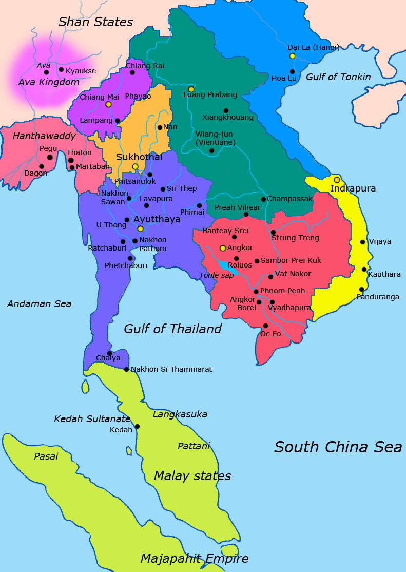
English: Map of Southeast Asia circa 1400 CE, showing Khmer Empire in red, Ayutthaya Kingdom in violet, Lan Xang kingdom in teal, Sukhothai kingdom in orange, Champa in yellow, Kingdom of Lanna in purple, Dai Viet in blue and surrounding states. |
| Data | |
| Jatorria |
http://ecaimaps.berkeley.edu/animations/2003_03_khmer_animation.swf http://www.britannica.com/EBchecked/media/3395/Khmer-empire-1200 Atlas of world history, Patrick Karl O'brien. Societies, Networks, and Transitions: A Global History, Volume B. Craig A.Lockard http://upload.wikimedia.org/wikipedia/commons/thumb/4/45/Srivijaya_Empire.svg/2000px-Srivijaya_Empire.svg.png File:DvaravatiMapThailand.png http://upload.wikimedia.org/wikipedia/commons/e/eb/Thailand_2002_CIA_map.jpg |
| Egilea | Javierfv1212 |
Lizentzia
| This file is made available under the Creative Commons CC0 1.0 Universal Public Domain Dedication. | |
| The person who associated a work with this deed has dedicated the work to the public domain by waiving all of their rights to the work worldwide under copyright law, including all related and neighboring rights, to the extent allowed by law. You can copy, modify, distribute and perform the work, even for commercial purposes, all without asking permission.
|
Fitxategiaren historia
Data/orduan klik egin fitxategiak orduan zuen itxura ikusteko.
| Data/Ordua | Iruditxoa | Neurriak | Erabiltzailea | Iruzkina | |
|---|---|---|---|---|---|
| oraingoa | 00:54, 26 urtarrila 2022 | | 791 × 1.114 (190 KB) | Yourlocallordandsavior | Reverted to version as of 17:40, 7 March 2021 (UTC) Inaccurate. |
| 10:44, 22 apirila 2021 |  | 1.080 × 1.521 (643 KB) | Monaonh | Map-of-southeast-asia_1400_CE.png | |
| 19:40, 7 martxoa 2021 |  | 791 × 1.114 (190 KB) | Monaonh | Reverted to version as of 17:26, 7 March 2021 (UTC) | |
| 19:34, 7 martxoa 2021 |  | 1.080 × 1.521 (643 KB) | Monaonh | File:Map-of-southeast-asia_1400_CE.png | |
| 19:26, 7 martxoa 2021 |  | 791 × 1.114 (190 KB) | Monaonh | Reverted to version as of 22:51, 19 July 2011 (UTC) | |
| 18:29, 6 martxoa 2021 |  | 1.080 × 1.521 (643 KB) | Monaonh | File:Map-of-southeast-asia_1400_CE.png | |
| 00:51, 20 uztaila 2011 |  | 791 × 1.114 (190 KB) | Ras67 | cropped | |
| 04:31, 28 martxoa 2011 |  | 800 × 1.125 (256 KB) | Javierfv1212 | {{Information |Description ={{en|1=Map of Southeast Asia circa 1300 CE, showing Khmer Empire in red, Ayutthaya Kingdom in violet, Lan Xang kingdom in teal, Sukhothai kingdom in orange, Champa in yellow, Kingdom of Lanna in purple, Dai Viet in blue and |
Irudira dakarten loturak
Hurrengo orrialdeek dute fitxategi honetarako lotura:
Fitxategiaren erabilera orokorra
Hurrengo beste wikiek fitxategi hau darabilte:
- ar.wikipedia.org proiektuan duen erabilera
- ast.wikipedia.org proiektuan duen erabilera
- azb.wikipedia.org proiektuan duen erabilera
- az.wikipedia.org proiektuan duen erabilera
- ba.wikipedia.org proiektuan duen erabilera
- br.wikipedia.org proiektuan duen erabilera
- ca.wikipedia.org proiektuan duen erabilera
- cs.wikipedia.org proiektuan duen erabilera
- de.wikipedia.org proiektuan duen erabilera
- en.wikipedia.org proiektuan duen erabilera
- eo.wikipedia.org proiektuan duen erabilera
- es.wikipedia.org proiektuan duen erabilera
- fa.wikipedia.org proiektuan duen erabilera
- fi.wikipedia.org proiektuan duen erabilera
- fr.wikipedia.org proiektuan duen erabilera
- hi.wikipedia.org proiektuan duen erabilera
- hr.wikipedia.org proiektuan duen erabilera
- id.wikipedia.org proiektuan duen erabilera
- it.wikipedia.org proiektuan duen erabilera
- ja.wikipedia.org proiektuan duen erabilera
Ikus fitxategi honen erabilpen global gehiago.