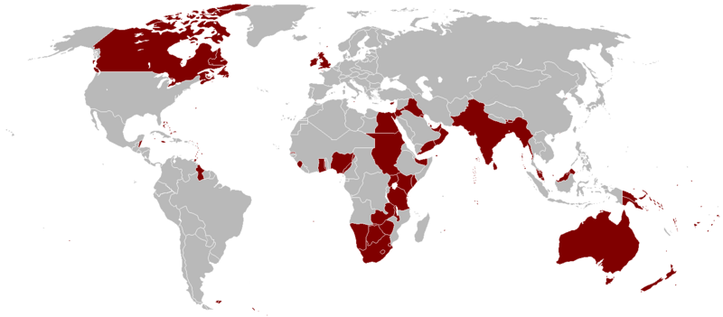
Fitxategi:British Empire 1921.png

Aurreikuspen honen neurria: 800 × 351 pixel. Bestelako bereizmenak: 320 × 140 pixel | 640 × 281 pixel | 1.425 × 625 pixel.
Bereizmen handikoa ((1.425 × 625 pixel, fitxategiaren tamaina: 58 KB, MIME mota: image/png))
Fitxategiaren historia
Data/orduan klik egin fitxategiak orduan zuen itxura ikusteko.
| Data/Ordua | Iruditxoa | Neurriak | Erabiltzailea | Iruzkina | |
|---|---|---|---|---|---|
| oraingoa | 05:14, 7 urria 2023 |  | 1.425 × 625 (58 KB) | Alanzx123 | added weihaiwei |
| 13:45, 25 uztaila 2023 |  | 1.425 × 625 (40 KB) | Przemko1 | Bhutan, Sikkim british protectorates | |
| 10:02, 31 urria 2021 |  | 1.425 × 625 (40 KB) | Randomastwritter | juba | |
| 00:05, 15 martxoa 2019 |  | 1.425 × 625 (56 KB) | Horserice | Fixed Hong Kong. | |
| 18:27, 5 ekaina 2017 |  | 1.425 × 625 (31 KB) | Maproom | Altered borders between Egypt, Libya and Sudan to agree with File:BlankMap-World-1921.png, which supposedly shows the correct borders as at 1921. | |
| 21:44, 11 abendua 2015 |  | 1.425 × 625 (32 KB) | Braganza | Tibet existed until 1949 | |
| 21:35, 3 iraila 2015 |  | 1.425 × 625 (35 KB) | फ़िलप्रो | Fixed Nepal, Sikkim, and Bhutan. They were de facto princely states / protectorates of the British Empire. | |
| 23:02, 26 martxoa 2015 |  | 1.425 × 625 (39 KB) | David C. S. | Ecudor in 1921 | |
| 21:00, 7 maiatza 2011 |  | 1.425 × 625 (49 KB) | Quigley | Correct China's borders closer to what was internationally recognized at the time | |
| 03:33, 13 urria 2010 |  | 1.425 × 625 (50 KB) | Vadac | Uploaded a clearer version with traditional British colour, added critical islands in Pacific and Caribbean and fixed the boarders of countries at the time such as Tuva among others |
Irudira dakarten loturak
Hurrengo orrialdeek dute fitxategi honetarako lotura:
Fitxategiaren erabilera orokorra
Hurrengo beste wikiek fitxategi hau darabilte:
- af.wikipedia.org proiektuan duen erabilera
- als.wikipedia.org proiektuan duen erabilera
- am.wikipedia.org proiektuan duen erabilera
- ar.wikipedia.org proiektuan duen erabilera
- ast.wikipedia.org proiektuan duen erabilera
- azb.wikipedia.org proiektuan duen erabilera
- az.wikipedia.org proiektuan duen erabilera
- bg.wikipedia.org proiektuan duen erabilera
- bn.wikipedia.org proiektuan duen erabilera
- br.wikipedia.org proiektuan duen erabilera
- ca.wikipedia.org proiektuan duen erabilera
- cs.wikipedia.org proiektuan duen erabilera
- da.wikipedia.org proiektuan duen erabilera
- de.wikipedia.org proiektuan duen erabilera
- el.wikipedia.org proiektuan duen erabilera
- en.wikipedia.org proiektuan duen erabilera
Ikus fitxategi honen erabilpen global gehiago.

