Fitxategi:Nautical chart of Mediterranean area, including Europe with British Isles and part of Scandinavia.jpg

Bereizmen handikoa ((9.410 × 6.909 pixel, fitxategiaren tamaina: 18 MB, MIME mota: image/jpeg))
Fitxategi hau Wikimedia Commonsekoa da. Hango deskribapen orriko informazioa behean duzu. |
| Warning | The original file is very high-resolution. It might not load properly or could cause your browser to freeze when opened at full size. |
|---|
Laburpena
| Deskribapena |
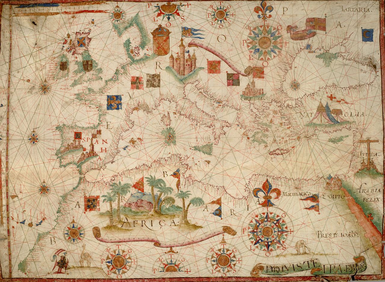
English: Nautical chart of Mediterranean area, including Europe with British Isles and part of Scandinavia.
Call Number: HM 1549 The map shows shields or heraldic banners of a number of realms, including:
|
| Data | circa 1600 |
| Jatorria | berkeley.edu |
| Egilea | Ezezaguna |
| Beste bertsioak |
|


Source:
Lizentzia
|
Honoko hau, domeinu publikoan dagoen bi dimentsioko artelan baten argazki-erreprodukzio fidela da. Artelana domeinu publikoan dago ondoko arrazoi hauengatik:
Wikimedia Fundazioak duen jarrera ofiziala hau da:«domeinu publikoan dauden bi dimentsioko erreprodukzio fidelak domeinu publikokoak dira.»
Argazki-erreprodukzio hau, beraz, domeinu publikokotzat hartzen da Estatu Batuetan. Beste jurisdikzio batzuetan eduki honen berrerabilera mugatua egon liteke; xehetasunetarako, ikus Reuse of PD-Art photographs. | ||||
Fitxategiaren historia
Data/orduan klik egin fitxategiak orduan zuen itxura ikusteko.
| Data/Ordua | Iruditxoa | Neurriak | Erabiltzailea | Iruzkina | |
|---|---|---|---|---|---|
| oraingoa | 09:22, 1 urtarrila 2011 | | 9.410 × 6.909 (18 MB) | Geagea | test |
| 09:30, 25 abendua 2010 |  | 5.792 × 3.672 (6,33 MB) | AnonMoos | Reverted to version as of 12:06, 24 December 2010 -- other version definitely not working | |
| 06:55, 25 abendua 2010 | Ez dago iruditxorik | 0 × 0 (29,52 MB) | Geagea | Reverted to version as of 04:47, 25 December 2010 | |
| 14:06, 24 abendua 2010 |  | 5.792 × 3.672 (6,33 MB) | AnonMoos | losslessly cropping | |
| 04:03, 24 abendua 2010 |  | 5.948 × 4.131 (6,66 MB) | Geagea | == {{int:filedesc}} == {{Information |Description={{en|1=Nautical chart of Mediterranean area, including Europe with British Isles and part of Scandinavia. Call Number: HM 1549}} |Source=[http://digitalassets.lib.berkeley.edu/ds/huntington/images//000561B |
Irudira dakarten loturak
Hurrengo orrialdeek dute fitxategi honetarako lotura:
Fitxategiaren erabilera orokorra
Hurrengo beste wikiek fitxategi hau darabilte:
- en.wikipedia.org proiektuan duen erabilera
- es.wikipedia.org proiektuan duen erabilera
- fr.wikipedia.org proiektuan duen erabilera