Fitxategi:Kingdoms around Israel 830 map.svg

SVG fitxategi honen PNG aurreikuspenaren tamaina: 502 × 599 pixel. Bestelako bereizmenak: 201 × 240 pixel | 402 × 480 pixel | 644 × 768 pixel | 858 × 1.024 pixel | 1.717 × 2.048 pixel | 720 × 859 pixel.
Bereizmen handikoa (SVG fitxategia, nominaldi 720 × 859 pixel, fitxategiaren tamaina: 122 KB)
Fitxategi hau Wikimedia Commonsekoa da. Hango deskribapen orriko informazioa behean duzu. |
| Deskribapena |
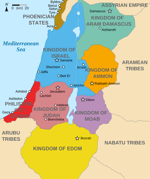
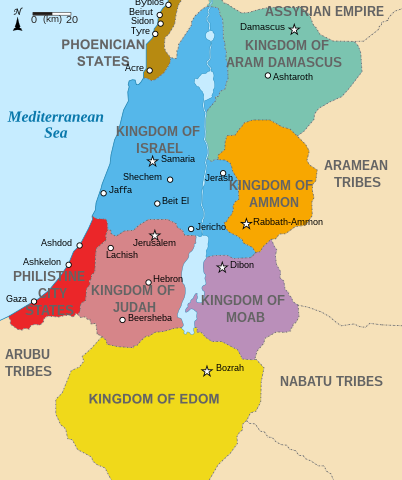
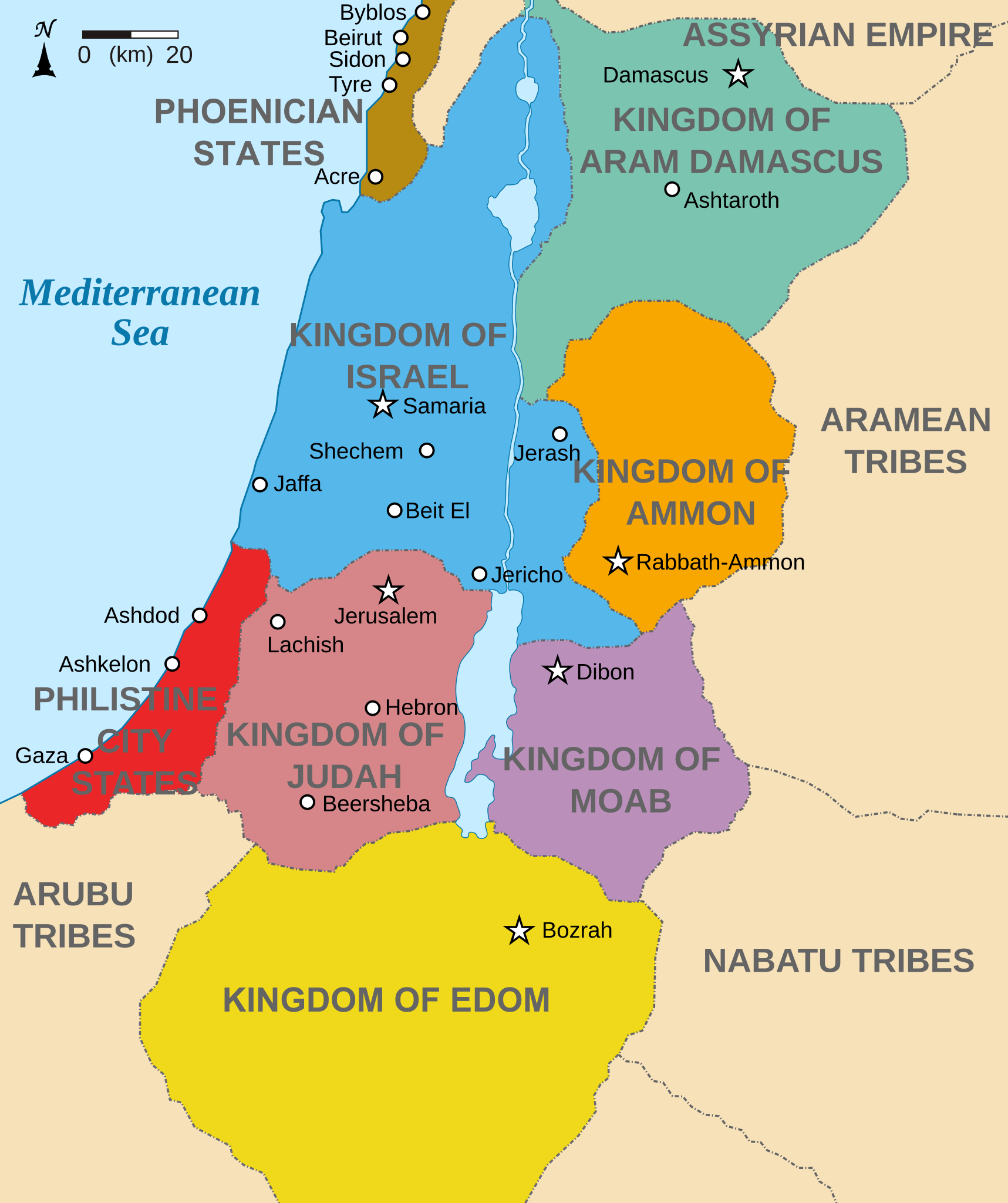
English: Map showing states around Israel & Judah. The Kingdoms around Israel & Judah are colored:
|
| Data | (UTC) |
| Jatorria | |
| Egilea |
|
| Beste bertsioak |
[]
|


Nik, lan honen egileak, argitaratzen dut ondorengo lizentzia hauen pean:
Fitxategi hau Creative Commons Attribution-Share Alike 3.0 Unported lizentziapean dago.
- Askea zara:
- partekatzeko – lana kopiatzeko, banatzeko eta bidaltzeko
- birnahasteko – lana moldatzeko
- Ondorengo baldintzen pean:
- eskuduntza – Egiletza behar bezala aitortu behar duzu, lizentzia ikusteko esteka gehitu, eta ea aldaketak egin diren aipatu. Era egokian egin behar duzu hori guztia, baina inola ere ez egileak zure lana edo zure erabilera babesten duela irudikatuz.
- berdin partekatu – Lan honetan oinarrituta edo aldatuta berria eraikitzen baduzu, emaitza lana hau bezalako lizentzia batekin argitaratu behar duzu.

|
Baimena duzu dokumentu hau kopiatu, banatu edo/eta aldatzeko GNU Free Documentation License baldintzapean, Free Software Foundationek argitaratutako 1.2 edo ondorengo bertsioan; sekzio aldaezinik gabe, azaleko testurik gabe, eta atzeko azaleko testurik gabe. Lizentziaren kopia dago GNU Free Documentation License izenburudun atalean. |
Nahiago duzun lizentzia erabil dezakezu.
Jatorrizko igoera erregistroa
This image is a derivative work of the following images:
- File:Kingdoms_of_Israel_and_Judah_map_830.svg licensed with Cc-by-sa-3.0, GFDL
- 2010-07-13T10:51:49Z Richardprins 720x859 (80858 Bytes) Added colors for the two kingdoms and converted their text to path and arial
- 2010-07-12T23:53:35Z Richardprins 720x859 (63843 Bytes) Shrinked down the borders
- 2010-07-12T19:43:31Z Richardprins 720x859 (63800 Bytes) {{Information |Description={{en|1=Map showing the ancient levant borders and ancient cities such as [[Urmomium]] and [[Jerash]]. The map also shows the region in the 9th century BCE. Notice the coastal land of Philistia, from
Uploaded with derivativeFX
Fitxategiaren historia
Data/orduan klik egin fitxategiak orduan zuen itxura ikusteko.
| Data/Ordua | Iruditxoa | Neurriak | Erabiltzailea | Iruzkina | |
|---|---|---|---|---|---|
| oraingoa | 17:32, 29 urria 2022 | | 720 × 859 (122 KB) | Muchado | Fixing font problems (hopefully) |
| 17:11, 29 urria 2022 |  | 720 × 859 (283 KB) | Muchado | Added "Philistine City States" which was unintentionally missed off... | |
| 17:06, 29 urria 2022 |  | 720 × 859 (239 KB) | Muchado | Coloured states, removed anachronistic Petra, added Bozrah, removed Urmomium (Your mom...!), edited Arabu to Arubu, edited to Philistine City States | |
| 17:51, 10 otsaila 2017 |  | 720 × 859 (167 KB) | Malus Catulus | Removed 'Sizu' - a weird artifact from the Norse original | |
| 14:58, 13 uztaila 2010 |  | 720 × 859 (165 KB) | Malus Catulus | livened up the colors, converted med sea text to path | |
| 13:26, 13 uztaila 2010 |  | 720 × 859 (139 KB) | Malus Catulus | {{Information |Description={{en|1=Map showing the ancient levant borders and ancient cities such as Urmomium and Jerash. The Kingdoms around Israel and Judah are colored. The map also shows the region in the 9th century BCE. Notice the coastal lan |
Irudira dakarten loturak
Fitxategiaren erabilera orokorra
Hurrengo beste wikiek fitxategi hau darabilte:
- af.wikipedia.org proiektuan duen erabilera
- arc.wikipedia.org proiektuan duen erabilera
- ar.wikipedia.org proiektuan duen erabilera
- arz.wikipedia.org proiektuan duen erabilera
- azb.wikipedia.org proiektuan duen erabilera
- bg.wikipedia.org proiektuan duen erabilera
- bn.wikipedia.org proiektuan duen erabilera
- br.wikipedia.org proiektuan duen erabilera
- ca.wikipedia.org proiektuan duen erabilera
- cs.wikipedia.org proiektuan duen erabilera
- da.wikipedia.org proiektuan duen erabilera
- en.wikipedia.org proiektuan duen erabilera
- Ammon
- History of the ancient Levant
- Kingdom of Judah
- Kingdom of Israel (Samaria)
- Philistines
- Moab
- Philistia
- Talk:Phoenician language
- Aram-Damascus
- Edom
- Portal:Bible/Featured chapter/Psalms
- Portal:Bible/Featured chapter/Psalms 83
- User:Kazkaskazkasako/Books/History
- Transjordan (region)
- Ezekiel 25
- User:Falcaorib
- User:Jacksonmcdonald3425/sandbox
- en.wiktionary.org proiektuan duen erabilera
- eo.wikipedia.org proiektuan duen erabilera
- et.wikipedia.org proiektuan duen erabilera
- fa.wikipedia.org proiektuan duen erabilera
Ikus fitxategi honen erabilpen global gehiago.