Fitxategi:1784 Bocage Map of The Bosphorus and the City of Byzantium - Istanbul - Constantinople - Geographicus - Bosphorus-white-1793.jpg
Aurreikuspen honen neurria: 800 × 544 pixel. Bestelako bereizmenak: 320 × 218 pixel | 640 × 436 pixel | 1.024 × 697 pixel | 1.280 × 871 pixel | 2.000 × 1.361 pixel.
Bereizmen handikoa ((2.000 × 1.361 pixel, fitxategiaren tamaina: 665 KB, MIME mota: image/jpeg))
Fitxategi hau Wikimedia Commonsekoa da. Hango deskribapen orriko informazioa behean duzu. |
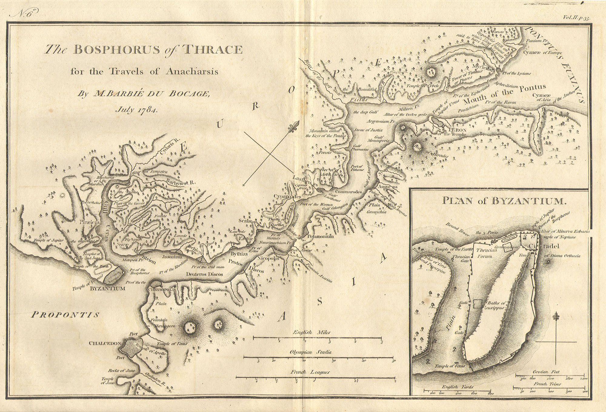
| Bosphorus and the city of Byzantium. | ||||||
|---|---|---|---|---|---|---|
| Artista | ||||||
| Izenburua |
Bosphorus and the city of Byzantium. |
|||||
| Deskribapena |
English: This lovely map, depicting the Bosphorus and the city of Byzantium, was prepared by Jean-Denis Barbié du Bocage in 1784 for the “Travels of Anarcharsis”. The map shows the narrow naval passage from the Propontis (Sea of Marmara) to the Pontus Euxinus (Black Sea). There is a beautiful inset plan of the Horn of Byzantium. Today Byzantium is Istanbul, but the horn and many of the ancient structures still exists. This map also shows the area in considerable topographical detail. |
|||||
| Data | 1784 | |||||
| Neurriak | altuera: 8,5 in (21,5 cm); Zabalera: 12 in (30,4 cm) | |||||
| Erregistro-zenbakia |
Geographicus link: Bosphorus-white-1793 |
|||||
| Jatorria/Argazkilaria |
|
|||||
| Lizentzia (Fitxategi hau berrerabiltzen) |
|
|||||
| Beste bertsioak | ||||||

Fitxategiaren historia
Data/orduan klik egin fitxategiak orduan zuen itxura ikusteko.
| Data/Ordua | Iruditxoa | Neurriak | Erabiltzailea | Iruzkina | |
|---|---|---|---|---|---|
| oraingoa | 22:46, 15 martxoa 2011 | | 2.000 × 1.361 (665 KB) | BotMultichill | {{subst:User:Multichill/Geographicus |link=http://www.geographicus.com/P/AntiqueMap/Bosphorus-white-1793 |product_name=1784 Bocage Map of The Bosphorus and the City of Byzantium / Istanbul / Constantinople |map_title=Bosphorus and the city of Byzantium. | |
Irudira dakarten loturak
Hurrengo orrialdeek dute fitxategi honetarako lotura:
Fitxategiaren erabilera orokorra
Hurrengo beste wikiek fitxategi hau darabilte:
- ar.wikipedia.org proiektuan duen erabilera
- arz.wikipedia.org proiektuan duen erabilera
- ast.wikipedia.org proiektuan duen erabilera
- az.wikipedia.org proiektuan duen erabilera
- ca.wikipedia.org proiektuan duen erabilera
- cs.wikipedia.org proiektuan duen erabilera
- el.wikipedia.org proiektuan duen erabilera
- en.wikipedia.org proiektuan duen erabilera
- eo.wikipedia.org proiektuan duen erabilera
- gl.wikipedia.org proiektuan duen erabilera
- he.wikivoyage.org proiektuan duen erabilera
- hu.wikipedia.org proiektuan duen erabilera
- hy.wikipedia.org proiektuan duen erabilera
- it.wikipedia.org proiektuan duen erabilera
- nap.wikipedia.org proiektuan duen erabilera
- pt.wikipedia.org proiektuan duen erabilera
- ro.wikipedia.org proiektuan duen erabilera
- sk.wikipedia.org proiektuan duen erabilera
- tr.wikipedia.org proiektuan duen erabilera
- www.wikidata.org proiektuan duen erabilera
- zh.wikipedia.org proiektuan duen erabilera