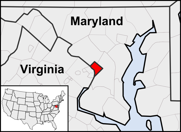
Fitxategi:Washington, D.C. locator map.svg

SVG fitxategi honen PNG aurreikuspenaren tamaina: 750 × 550 pixel. Bestelako bereizmenak: 320 × 235 pixel | 640 × 469 pixel | 1.024 × 751 pixel | 1.280 × 939 pixel | 2.560 × 1.877 pixel.
Bereizmen handikoa (SVG fitxategia, nominaldi 750 × 550 pixel, fitxategiaren tamaina: 160 KB)
Fitxategiaren historia
Data/orduan klik egin fitxategiak orduan zuen itxura ikusteko.
| Data/Ordua | Iruditxoa | Neurriak | Erabiltzailea | Iruzkina | |
|---|---|---|---|---|---|
| oraingoa | 05:23, 23 uztaila 2011 |  | 750 × 550 (160 KB) | Patrickneil | Reverted to version as of 03:04, 23 July 2011 |
| 05:21, 23 uztaila 2011 |  | 750 × 550 (161 KB) | Patrickneil | Reverted to version as of 03:14, 23 July 2011 | |
| 05:20, 23 uztaila 2011 |  | 750 × 550 (161 KB) | Patrickneil | frame | |
| 05:14, 23 uztaila 2011 |  | 750 × 550 (161 KB) | Patrickneil | thicker frame | |
| 05:04, 23 uztaila 2011 |  | 750 × 550 (160 KB) | Patrickneil | straightening Maryland and Delaware borders | |
| 04:09, 15 abuztua 2010 |  | 750 × 550 (202 KB) | Patrickneil | Delaware River again | |
| 03:51, 15 abuztua 2010 |  | 750 × 550 (274 KB) | Patrickneil | Delaware River border | |
| 03:42, 15 abuztua 2010 |  | 750 × 550 (273 KB) | Patrickneil | forgot border on Smith Island | |
| 03:34, 15 abuztua 2010 |  | 750 × 550 (273 KB) | Patrickneil | county borders below state | |
| 03:32, 15 abuztua 2010 |  | 750 × 550 (274 KB) | Patrickneil | changes by request |
Irudira dakarten loturak
Ez dago fitxategi hau darabilen orririk.
Fitxategiaren erabilera orokorra
Hurrengo beste wikiek fitxategi hau darabilte:
- af.wikipedia.org proiektuan duen erabilera
- an.wikipedia.org proiektuan duen erabilera
- ar.wikipedia.org proiektuan duen erabilera
- arz.wikipedia.org proiektuan duen erabilera
- as.wikipedia.org proiektuan duen erabilera
- azb.wikipedia.org proiektuan duen erabilera
- bh.wikipedia.org proiektuan duen erabilera
- bs.wikipedia.org proiektuan duen erabilera
- ceb.wikipedia.org proiektuan duen erabilera
- ckb.wikipedia.org proiektuan duen erabilera
- en.wikipedia.org proiektuan duen erabilera
- en.wikinews.org proiektuan duen erabilera
- es.wikipedia.org proiektuan duen erabilera
- es.wiktionary.org proiektuan duen erabilera
- et.wikipedia.org proiektuan duen erabilera
- fr.wikipedia.org proiektuan duen erabilera
- fr.wiktionary.org proiektuan duen erabilera
- fy.wikipedia.org proiektuan duen erabilera
- gv.wikipedia.org proiektuan duen erabilera
- hu.wikipedia.org proiektuan duen erabilera
- ia.wikipedia.org proiektuan duen erabilera
- id.wikipedia.org proiektuan duen erabilera
- ilo.wikipedia.org proiektuan duen erabilera
- incubator.wikimedia.org proiektuan duen erabilera
- it.wikipedia.org proiektuan duen erabilera
- jam.wikipedia.org proiektuan duen erabilera
- ja.wikipedia.org proiektuan duen erabilera
- jbo.wikipedia.org proiektuan duen erabilera
- ko.wikipedia.org proiektuan duen erabilera
- lb.wikipedia.org proiektuan duen erabilera
- lfn.wikipedia.org proiektuan duen erabilera
- ln.wikipedia.org proiektuan duen erabilera
Ikus fitxategi honen erabilpen global gehiago.
