Fitxategi:WILSON'S MILL, FORMERLY KNOWN AS ALEXANDER'S MILL, ON THE OHIO-ERIE CANAL SOUTH OF ALEXANDER ROAD NEAR VALLEY VIEW... - NARA - 558001.jpg

Bereizmen handikoa ((3.000 × 2.034 pixel, fitxategiaren tamaina: 1.001 KB, MIME mota: image/jpeg))
Fitxategi hau Wikimedia Commonsekoa da. Hango deskribapen orriko informazioa behean duzu. |
|
This is an image of a place or building that is listed on the National Register of Historic Places in the United States of America. Its reference number is 79000298. |
Laburpena
| Egilea |
Frank J. (Frank John) Aleksandrowicz, 1921-, Photographer (NARA record: 8452210) |
||||||||||||||||||||||||||
| Record creator | Environmental Protection Agency. (12/02/1970 - ) | ||||||||||||||||||||||||||
| Izenburua |
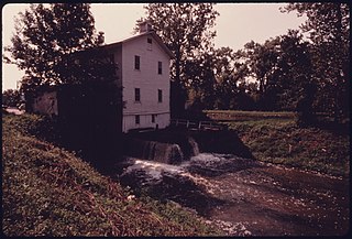
WILSON'S MILL, FORMERLY KNOWN AS ALEXANDER'S MILL, ON THE OHIO-ERIE CANAL SOUTH OF ALEXANDER ROAD NEAR VALLEY VIEW AND CLEVELAND, OHIO. WHEN IT OPERATED, CANAL WATER DROPPED THROUGH A SLUICE WHICH PROVIDED POWER TO GRIND GRAIN. THE CANAL CONNECTED THE GREAT LAKES WITH THE OHIO AND MISSISSIPPI RIVER SYSTEMS BETWEEN 1833 AND 1913 WHEN A FLOOD AND THE RAILROADS PUT THE WATERWAY OUT OF BUSINESS. THE SITE IS NOW PART OF THE CUYAHOGA VALLEY NATIONAL RECREATION AREA |
||||||||||||||||||||||||||
| Depicted place |
Cleveland (Cuyahoga county, Ohio, United States, North and Central America) inhabited place (41°28′59″N 81°40′59″W / 41.483°N 81.683°W; NARA geographical record) |
||||||||||||||||||||||||||
| Data | 1975ko iraila | ||||||||||||||||||||||||||
| Bilduma |
|
||||||||||||||||||||||||||
| Record ID |
NAIL Control Number: NWDNS-412-DA-15551
|
||||||||||||||||||||||||||
| Jatorria | U.S. National Archives and Records Administration | ||||||||||||||||||||||||||
| Beste bertsioak |
Please do not overwrite this file: any cropping or other restoration work should be uploaded with a new name and linked in this page's "other versions=" parameter, so that this file represents the exact file found in the NARA catalog record to which it links. The metadata on this page was imported directly from NARA's catalog record; additional descriptive text may be added by Wikimedians to the template below with the "description=" parameter, but please do not modify the other fields. translate
|
||||||||||||||||||||||||||


Lizentzia
This file was provided to Wikimedia Commons by the National Archives and Records Administration as part of a cooperation project. The National Archives and Records Administration provides images depicting American and global history which are public domain or licensed under a free license.
|
This image (or other media) is a work of an Environmental Protection Agency employee, taken or made as part of that person's official duties. As works of the U.S. federal government, all EPA images are in the public domain.
|
||
| Objektuaren kokapena | | Irudi hau eta gehiago beraien kokapenekin hurrengo lekuetan: OpenStreetMap |
|---|
Fitxategiaren historia
Data/orduan klik egin fitxategiak orduan zuen itxura ikusteko.
| Data/Ordua | Iruditxoa | Neurriak | Erabiltzailea | Iruzkina | |
|---|---|---|---|---|---|
| oraingoa | 06:19, 20 urria 2011 | | 3.000 × 2.034 (1.001 KB) | US National Archives bot | == {{int:filedesc}} == {{NARA-image-full | Title = WILSON'S MILL, FORMERLY KNOWN AS ALEXANDER'S MILL, ON THE OHIO-ERIE CANAL SOUTH OF ALEXANDER ROAD NEAR VALLEY VIEW AND CLEVELAND, OHIO. WHEN IT OPERATED, CANAL WATER DROPPED THROUGH A |
Irudira dakarten loturak
Hurrengo orrialdeek dute fitxategi honetarako lotura:
Fitxategiaren erabilera orokorra
Hurrengo beste wikiek fitxategi hau darabilte:
- ar.wikipedia.org proiektuan duen erabilera
- azb.wikipedia.org proiektuan duen erabilera
- ca.wikipedia.org proiektuan duen erabilera
- ceb.wikipedia.org proiektuan duen erabilera
- cy.wikipedia.org proiektuan duen erabilera
- en.wikipedia.org proiektuan duen erabilera
- en.wikivoyage.org proiektuan duen erabilera
- fa.wikipedia.org proiektuan duen erabilera
- fr.wikipedia.org proiektuan duen erabilera
- ht.wikipedia.org proiektuan duen erabilera
- it.wikipedia.org proiektuan duen erabilera
- it.wikivoyage.org proiektuan duen erabilera
- lld.wikipedia.org proiektuan duen erabilera
- pl.wikipedia.org proiektuan duen erabilera
- pt.wikipedia.org proiektuan duen erabilera
- sr.wikipedia.org proiektuan duen erabilera
- uk.wikipedia.org proiektuan duen erabilera
- vi.wikipedia.org proiektuan duen erabilera
- www.wikidata.org proiektuan duen erabilera
- zh-min-nan.wikipedia.org proiektuan duen erabilera