Fitxategi:Volcanic-ash-downfall map of Mt.Fuji Hoei-eruption01.jpg

Bereizmen handikoa ((1.935 × 1.364 pixel, fitxategiaren tamaina: 1,54 MB, MIME mota: image/jpeg))
Fitxategi hau Wikimedia Commonsekoa da. Hango deskribapen orriko informazioa behean duzu. |
Laburpena
| Deskribapena |
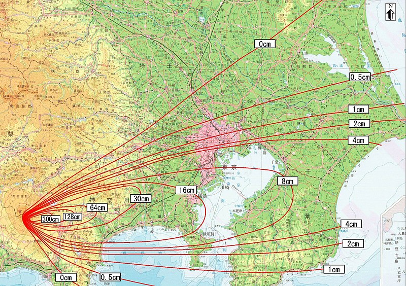
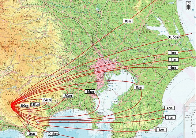
日本語: 防災対応を検討するための降灰分布図(富士山宝永噴火)
English: Ashfall distribution map for examining disaster prevention measures (Mt. Fuji Hoei eruption) |
||
| Data | 中間報告〔平成14年6月12日〕(the interim report was released on 2002-6-12) | ||
| Jatorria |
日本語: 富士山ハザードマップ検討委員会中間報告
English: Mt. Fuji Hazard Map Review Committee Interim Report
http://www.bousai.go.jp/fujisan/h_map/kentou/interim_report/ http://www.bousai.go.jp/fujisan/h_map/kentou/interim_report/all_p.pdf 出典:富士山防災協議会(the Mt.Fuji Volcano Disaster Management Conference) |
||
| Egilea | 富士山防災協議会 (Mt. Fuji Disaster Prevention Council); Miya.m added the URL and the information to the Map and uploaded under the permission of the Cabinet Office of the Japanese Government | ||
| Lizentzia (Fitxategi hau berrerabiltzen) |
This file is licensed under the Creative Commons Attribution 4.0 International license. Aitortu: 内閣府防災のページ
|
||
| Beste bertsioak | Image:Hazard Map of Mt.Fuji common l.jpg |

Lizentzia
work of "the Mt.Fuji Volcano Disaster Management Conference" (http://www.bousai.go.jp/fujisan-kyougikai/ archive copy at the Wayback Machine) supported by Japanese government cabinet officials (http://www.bousai.go.jp/); confirmed to be CC-by-4.0(cf:[1])
- Askea zara:
- partekatzeko – lana kopiatzeko, banatzeko eta bidaltzeko
- birnahasteko – lana moldatzeko
- Ondorengo baldintzen pean:
- eskuduntza – Egiletza behar bezala aitortu behar duzu, lizentzia ikusteko esteka gehitu, eta ea aldaketak egin diren aipatu. Era egokian egin behar duzu hori guztia, baina inola ere ez egileak zure lana edo zure erabilera babesten duela irudikatuz.
-
Fitxategiaren historia
Data/orduan klik egin fitxategiak orduan zuen itxura ikusteko.
| Data/Ordua | Iruditxoa | Neurriak | Erabiltzailea | Iruzkina | |
|---|---|---|---|---|---|
| oraingoa | 08:38, 18 abendua 2017 | | 1.935 × 1.364 (1,54 MB) | ديفيد عادل وهبة خليل 2 | Removed border by cropping 3 % horizontally and 12 % vertically using CropTool with precise mode. |
| 18:45, 21 martxoa 2006 |  | 2.000 × 1.550 (1,79 MB) | Miya.m | {{Information| |Description = 富士山宝永噴火降灰分布実績図(The result map of the volcanic ashes downfall of Mt.Fuji's Hoei-eruption |Source =出典:富士山防災協議会(Mt.Fuji anti-disaster conference) http://www.bousai.go.jp/fuji |
Irudira dakarten loturak
Hurrengo orrialdeek dute fitxategi honetarako lotura:
Fitxategiaren erabilera orokorra
Hurrengo beste wikiek fitxategi hau darabilte:
- ast.wikipedia.org proiektuan duen erabilera
- ca.wikipedia.org proiektuan duen erabilera
- cs.wikipedia.org proiektuan duen erabilera
- da.wikipedia.org proiektuan duen erabilera
- de.wikipedia.org proiektuan duen erabilera
- en.wikipedia.org proiektuan duen erabilera
- es.wikipedia.org proiektuan duen erabilera
- fa.wikipedia.org proiektuan duen erabilera
- fr.wikipedia.org proiektuan duen erabilera
- he.wikipedia.org proiektuan duen erabilera
- hu.wikipedia.org proiektuan duen erabilera
- id.wikipedia.org proiektuan duen erabilera
- it.wikipedia.org proiektuan duen erabilera
- ja.wikipedia.org proiektuan duen erabilera
- ko.wikipedia.org proiektuan duen erabilera
- pt.wikipedia.org proiektuan duen erabilera
- ru.wikipedia.org proiektuan duen erabilera
- simple.wikipedia.org proiektuan duen erabilera
- sl.wikipedia.org proiektuan duen erabilera
- sr.wikipedia.org proiektuan duen erabilera
- sv.wikipedia.org proiektuan duen erabilera
- th.wikipedia.org proiektuan duen erabilera
- tr.wikipedia.org proiektuan duen erabilera
- www.wikidata.org proiektuan duen erabilera
- zh.wikipedia.org proiektuan duen erabilera