Fitxategi:Viking Expansion-es.svg

SVG fitxategi honen PNG aurreikuspenaren tamaina: 793 × 521 pixel. Bestelako bereizmenak: 320 × 210 pixel | 640 × 420 pixel | 1.024 × 673 pixel | 1.280 × 841 pixel | 2.560 × 1.682 pixel.
Bereizmen handikoa (SVG fitxategia, nominaldi 793 × 521 pixel, fitxategiaren tamaina: 1,33 MB)
Fitxategi hau Wikimedia Commonsekoa da. Hango deskribapen orriko informazioa behean duzu. |
Laburpena
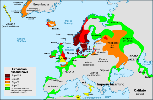
| Deskribapena |
Português: Mapa da expansão viquingue Español: Mapa de la expansión vikinga. |
| Data | |
| Jatorria |
Fitxategi hau hemendik eratorria izan da: Viking Expansion-pt.svg : Max Naylor |
| Egilea |
|
| Beste bertsioak |
[]
|


Lizentzia
Nik, lan honen egileak, argitaratzen dut ondorengo lizentzia pean:
Fitxategi hau Creative Commons Attribution-Share Alike 3.0 Unported lizentziapean dago.
- Askea zara:
- partekatzeko – lana kopiatzeko, banatzeko eta bidaltzeko
- birnahasteko – lana moldatzeko
- Ondorengo baldintzen pean:
- eskuduntza – Egiletza behar bezala aitortu behar duzu, lizentzia ikusteko esteka gehitu, eta ea aldaketak egin diren aipatu. Era egokian egin behar duzu hori guztia, baina inola ere ez egileak zure lana edo zure erabilera babesten duela irudikatuz.
- berdin partekatu – Lan honetan oinarrituta edo aldatuta berria eraikitzen baduzu, emaitza lana hau bezalako lizentzia batekin argitaratu behar duzu.
Fitxategiaren historia
Data/orduan klik egin fitxategiak orduan zuen itxura ikusteko.
| Data/Ordua | Iruditxoa | Neurriak | Erabiltzailea | Iruzkina | |
|---|---|---|---|---|---|
| oraingoa | 17:46, 26 otsaila 2018 | | 793 × 521 (1,33 MB) | Asmodim | Added the areas of the Norman "Kingdom of Africa" (see article on english wikipedia), conquest part of the Norman kingdom of Sicily under Roger II. |
| 11:55, 7 urtarrila 2017 |  | 793 × 521 (1,32 MB) | Rowanwindwhistler | https://en.wikipedia.org/wiki/Wikipedia:WikiProject_Maps/Conventions Fake text added | |
| 19:55, 15 uztaila 2014 |  | 793 × 521 (738 KB) | Rowanwindwhistler | User created page with UploadWizard |
Irudira dakarten loturak
Hurrengo orrialdeek dute fitxategi honetarako lotura:
Fitxategiaren erabilera orokorra
Hurrengo beste wikiek fitxategi hau darabilte:
- ast.wikipedia.org proiektuan duen erabilera
- es.wikipedia.org proiektuan duen erabilera
- es.wikibooks.org proiektuan duen erabilera