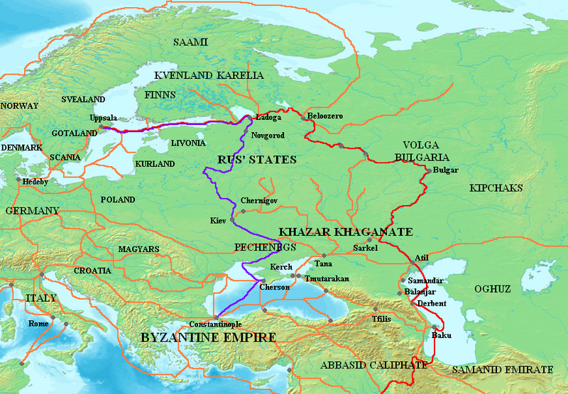
Fitxategi:Varangian routes.png

Aurreikuspen honen neurria: 800 × 555 pixel. Bestelako bereizmenak: 320 × 222 pixel | 640 × 444 pixel | 872 × 605 pixel.
Bereizmen handikoa ((872 × 605 pixel, fitxategiaren tamaina: 859 KB, MIME mota: image/png))
Fitxategiaren historia
Data/orduan klik egin fitxategiak orduan zuen itxura ikusteko.
| Data/Ordua | Iruditxoa | Neurriak | Erabiltzailea | Iruzkina | |
|---|---|---|---|---|---|
| oraingoa | 13:29, 3 urria 2023 |  | 872 × 605 (859 KB) | OrionNimrod | Restore original: "Wallachians" added by Romanian user, however it was no Wallachia in the 8-11th c: British historian, Martyn Rady - Nobility, land and service in medieval Hungary (p91–93): the sources before the 13th century do not contain references to Vlachs anywhere in Hungary and Transylvania or in Wallachia. Byzantine sources mentioned Vlachs all deep in the Balcan. Also map should make by academic historians not by personal POV. |
| 20:23, 16 abuztua 2023 |  | 872 × 605 (799 KB) | Claude Zygiel | In one hand there are Byzantine sources which mention the Vlachs, secondly it is not because other sources do not mention them that they did not exist. In the other hand, the Hungarian theory which affirms that "the absence of proof is proof of absence", that this group disappeared for a thousand years, and that it would have been the only one, among all the peoples of the region , to not being able to cross the Balkans, the Danube and the Carpathians (while they were nomadic shepherds), is u... | |
| 12:54, 25 uztaila 2023 |  | 872 × 605 (794 KB) | OrionNimrod | "Wallachians" added by Romanian user, however it was no Wallachia in the 8-11th c: British historian, Martyn Rady - Nobility, land and service in medieval Hungary (p91–93): the sources before the 13th century do not contain references to Vlachs anywhere in Hungary and Transylvania or in Wallachia | |
| 09:29, 26 ekaina 2023 |  | 872 × 605 (799 KB) | Johannnes89 | Reverted to version as of 16:47, 18 April 2023 (UTC) crosswiki image spam, often containing historical inaccuracies | |
| 01:53, 26 ekaina 2023 |  | 872 × 605 (1.017 KB) | Valdazleifr | Fixed minor errors | |
| 18:47, 18 apirila 2023 |  | 872 × 605 (799 KB) | Claude Zygiel | There was no Wallachia but Wallachians. The theory that speakers of Eastern Romance languages disappeared for a thousand years between 275 and 1300 is only supported by Hungarian nationalist authors. | |
| 14:41, 25 azaroa 2022 |  | 872 × 605 (794 KB) | OrionNimrod | Reverted to version as of 15:59, 8 March 2009 (UTC) It was no Wallachia in the 8-11th century | |
| 14:44, 21 maiatza 2015 |  | 872 × 605 (799 KB) | Spiridon Ion Cepleanu | Dvina & Wisla-Dnestr route, some details | |
| 17:59, 8 martxoa 2009 |  | 872 × 605 (794 KB) | Mahahahaneapneap | Compressed | |
| 01:15, 19 urtarrila 2007 |  | 872 × 605 (859 KB) | Electionworld | {{ew|en|Briangotts}} == Summary == Map showing the major Varangian trade routes, the Volga trade route (in red) and the Trade Route from the Varangians to the Greeks (in purple). Other trade routes of the 8th-11th centuries shown in orange |
Irudira dakarten loturak
Hurrengo orrialdeek dute fitxategi honetarako lotura:
Fitxategiaren erabilera orokorra
Hurrengo beste wikiek fitxategi hau darabilte:
- af.wikipedia.org proiektuan duen erabilera
- ar.wikipedia.org proiektuan duen erabilera
- ast.wikipedia.org proiektuan duen erabilera
- az.wikipedia.org proiektuan duen erabilera
- be-tarask.wikipedia.org proiektuan duen erabilera
- be.wikipedia.org proiektuan duen erabilera
- bg.wikipedia.org proiektuan duen erabilera
- ca.wikipedia.org proiektuan duen erabilera
- ckb.wikipedia.org proiektuan duen erabilera
- cs.wikipedia.org proiektuan duen erabilera
- cv.wikipedia.org proiektuan duen erabilera
- cy.wikipedia.org proiektuan duen erabilera
- de.wikipedia.org proiektuan duen erabilera
- el.wikipedia.org proiektuan duen erabilera
- en.wikipedia.org proiektuan duen erabilera
Ikus fitxategi honen erabilpen global gehiago.


