Fitxategi:TchoutacabouffaRiver1998.jpg

Aurreikuspen honen neurria: 800 × 541 pixel. Bestelako bereizmenak: 320 × 217 pixel | 640 × 433 pixel | 875 × 592 pixel.
Bereizmen handikoa ((875 × 592 pixel, fitxategiaren tamaina: 152 KB, MIME mota: image/jpeg))
Fitxategi hau Wikimedia Commonsekoa da. Hango deskribapen orriko informazioa behean duzu. |
Laburpena
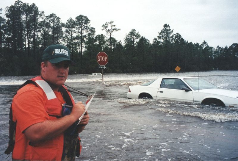
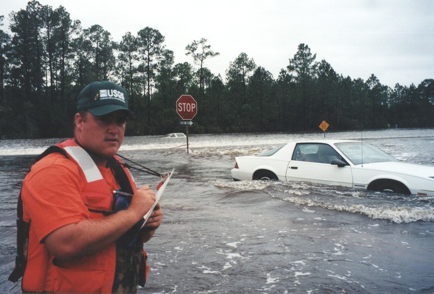
| Deskribapena | D'Iberville, Mississippi. Water flowing over Mississippi Highway 67 and Mississippi Highway 15 near their intersection during the September 1998 flooding caused on the Tchoutacabouffa River by Hurricane Georges. |
| Data | |
| Jatorria | USGS Surface Water Photo Gallery: item 17 11 |
| Egilea | Trent Baldwin (submitted by Van Wilson, Mississippi) |
| Lizentzia (Fitxategi hau berrerabiltzen) |
Public Domain |
| Kameraren kokapena | | Irudi hau eta gehiago beraien kokapenekin hurrengo lekuetan: OpenStreetMap |
|---|
Lizentzia
This image is in the public domain in the United States because it only contains materials that originally came from the United States Geological Survey, an agency of the United States Department of the Interior. For more information, see the official USGS copyright policy.
|
Wikipedia upload log
A Wikipedia description page is/was here. All following user names refer to en.wikipedia.
- 22:28, September 3, 2008 Suntag (34 bytes)
Fitxategiaren historia
Data/orduan klik egin fitxategiak orduan zuen itxura ikusteko.
| Data/Ordua | Iruditxoa | Neurriak | Erabiltzailea | Iruzkina | |
|---|---|---|---|---|---|
| oraingoa | 20:52, 9 otsaila 2011 | | 875 × 592 (152 KB) | Infrogmation | == Summary == {{Information |Description= D'Iberville, Mississippi. Water flowing over Old Hwy 67 and MS 15 near their intersection on September 29, 1998 during the September 1998 flooding caused on th |
Irudira dakarten loturak
Hurrengo orrialdeek dute fitxategi honetarako lotura:
Fitxategiaren erabilera orokorra
Hurrengo beste wikiek fitxategi hau darabilte:
- ar.wikipedia.org proiektuan duen erabilera
- arz.wikipedia.org proiektuan duen erabilera
- ca.wikipedia.org proiektuan duen erabilera
- ceb.wikipedia.org proiektuan duen erabilera
- ce.wikipedia.org proiektuan duen erabilera
- cy.wikipedia.org proiektuan duen erabilera
- en.wikipedia.org proiektuan duen erabilera
- en.wikivoyage.org proiektuan duen erabilera
- ht.wikipedia.org proiektuan duen erabilera
- it.wikipedia.org proiektuan duen erabilera
- ky.wikipedia.org proiektuan duen erabilera
- lld.wikipedia.org proiektuan duen erabilera
- pl.wikipedia.org proiektuan duen erabilera
- pt.wikipedia.org proiektuan duen erabilera
- tt.wikipedia.org proiektuan duen erabilera
- uz.wikipedia.org proiektuan duen erabilera
- vi.wikipedia.org proiektuan duen erabilera
- www.wikidata.org proiektuan duen erabilera
- zh-min-nan.wikipedia.org proiektuan duen erabilera