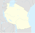
Fitxategi:Tanzania location map.svg

Bereizmen handikoa(SVG fitxategia, nominaldi 3.302 × 3.143 pixel, fitxategiaren tamaina: 1,04 MB)

Fitxategi hau Wikimedia Commonsekoa da. Hango deskribapen orriko informazioa behean duzu.
Commons gordailu bat da, lizentzia askea duten multimedia fitxategiena. Lagun dezakezu.

Fitxategi hau Wikimedia Commonsekoa da

Laburpena

Deskribapena
Afrikaans: Liggingkaart van Tanzanië
English: Location map of Tanzania
Español: Mapa de georreferenciación de Tanzania
Français : Carte de géolocalisation de la Tanzanie
Equirectangular projection. 0.25° N, 28° W, 42° E, -13° S. Center : -6.375 35
Data (UTC)
Jatorria
Egilea
Beste bertsioak

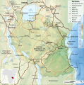
Derivative works of this file:  Iringa Regionen.png [aldatu]

Aitortu
(required by the license)
InfoField
© Sémhur / Wikimedia Commons / 
© Sémhur / Wikimedia Commons
SVG
InfoField
 
W3C-validity not checked.
 
Fitxategi hau (bektore-irudia) hau Inkscape-ekin sortu da . .
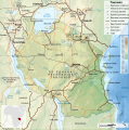
This is a retouched picture, which means that it has been digitally altered from its original version. Modifications: Cropped, and prepared for geolocation.. The original can be viewed here: Tanzania map-fr.svg. Modifications made by Sémhur.

Graphic Lab
InfoField
Objektuaren kokapena6° 22′ 30″ S, 35° 00′ 00″ E  Heading=1° Kartographer map based on OpenStreetMap.Irudi hau eta gehiago beraien kokapenekin hurrengo lekuetan: OpenStreetMapinfo

Lizentzia

Nik, lan honen egileak, argitaratzen dut ondorengo lizentzia hauen pean:
w:eu:Creative Commons
eskuduntza berdin partekatu
This file is licensed under the Creative Commons Attribution-Share Alike 4.0 International, 3.0 Unported, 2.5 Generic, 2.0 Generic and 1.0 Generic license.
Askea zara:
  • partekatzeko – lana kopiatzeko, banatzeko eta bidaltzeko
  • birnahasteko – lana moldatzeko
Ondorengo baldintzen pean:
  • eskuduntza – Egiletza behar bezala aitortu behar duzu, lizentzia ikusteko esteka gehitu, eta ea aldaketak egin diren aipatu. Era egokian egin behar duzu hori guztia, baina inola ere ez egileak zure lana edo zure erabilera babesten duela irudikatuz.
  • berdin partekatu – Lan honetan oinarrituta edo aldatuta berria eraikitzen baduzu, emaitza lana hau bezalako lizentzia batekin argitaratu behar duzu.
Licence Art Libre Copyleft: This work of art is free; you can redistribute it and/or modify it according to terms of the Free Art License. You will find a specimen of this license on the Copyleft Attitude site as well as on other sites.
Nahiago duzun lizentzia erabil dezakezu.

Jatorrizko igoera erregistroa

This image is a derivative work of the following images:

  • File:Tanzania_map-fr.svg licensed with Cc-by-sa-3.0,2.5,2.0,1.0, GFDL
    • 2009-03-20T13:30:18Z Sémhur 3096x3113 (3225659 Bytes) Ol Doinyo Lengaï was misplaced
    • 2009-03-20T11:14:35Z Sémhur 3096x3113 (3224368 Bytes) Add location map and few summits.
    • 2009-03-19T17:14:13Z Sémhur 3096x3113 (3099209 Bytes) grrr...
    • 2009-03-19T17:08:18Z Sémhur 3096x3113 (3099244 Bytes) Oups ! It wasn't the valid one.
    • 2009-03-19T17:05:02Z Sémhur 3096x3113 (3122421 Bytes) {{Information |Description={{en|1=Map of [[:en:Tanzania]].}} {{fr|1=Carte de la [[:fr:Tanzanie]].}} {{es|1=Mapa de [[:es:Tanzania]].}} |Source=travail personnel (own work). Sources of data: * Elevations : NASA SRTM3 (public d

Uploaded with derivativeFX

Jatorrizko igoera erregistroa

date/time username resolution size edit summary
2009-05-03T08:48:31Z User:Sémhur 3096×2947 828.71Kb borders above waters
2009-05-03T08:45:18Z User:Sémhur 3096×2947 828.72Kb Adding border between Arusha and Manyara
2009-05-01T18:46:42Z User:Sémhur 3096×2947 822.6Kb {{int:summary}} {{Information |Description={{en|1=Location map of [[:en:Tanzania]].}} {{fr|1=Carte de géolocalisation de la [[:fr:Tanzanie]].}} {{es|1=Mapa de georreferenciación de [[:es:Tanzania]].}} Equirectangular projection. 0.25° N, 28° W, 42°

Irudi-oineko testuak

Add a one-line explanation of what this file represents
Location map of Tanzania

Fitxategi honetan agertzen diren itemak

honako hau irudikatzen du

1 maiatza 2009

6°S, 35°E

heading ingelesa: 1 gradu sexagesimal

MIME type ingelesa

image/svg+xml

Fitxategiaren historia

Data/orduan klik egin fitxategiak orduan zuen itxura ikusteko.

Data/OrduaIruditxoaNeurriakErabiltzaileaIruzkina
oraingoa22:15, 25 maiatza 201722:15, 25 maiatza 2017 bertsioaren iruditxoa3.302 × 3.143 (1,04 MB)SémhurUpdated with Songwe Region
16:16, 13 abendua 201316:16, 13 abendua 2013 bertsioaren iruditxoa3.096 × 2.947 (1,03 MB)SémhurUpdated with the four new regions
02:30, 25 uztaila 200902:30, 25 uztaila 2009 bertsioaren iruditxoa3.096 × 2.947 (829 KB)BetacommandBotmove approved by: User:Sémhur This image was moved from File:Tanzania location equirectangular map.svg =={{int:summary}}== {{Information |Description={{en|1=Location map of en:Tanzania.}} {{fr|1=Carte de géolocalisation de la [[:fr:Tanz

Hurrengo orrialdeek dute fitxategi honetarako lotura:

Fitxategiaren erabilera orokorra

Metadatuak