Fitxategi:Taff Gorge from sandstone crag on Garth Hill - geograph.org.uk - 633985.jpg
Ez dago bereizmen handiagorik.
Taff_Gorge_from_sandstone_crag_on_Garth_Hill_-_geograph.org.uk_-_633985.jpg ((640 × 427 pixel, fitxategiaren tamaina: 65 KB, MIME mota: image/jpeg))
Fitxategi hau Wikimedia Commonsekoa da. Hango deskribapen orriko informazioa behean duzu. |
Laburpena
| Deskribapena |
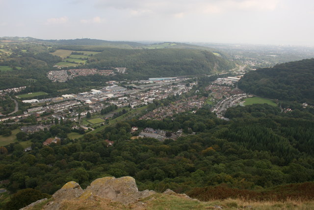
English: Taff Gorge from sandstone crag on Garth Hill Upper Carboniferous rocks underlie the foreground and have been mined historically for coal. The conspicuous settlement, Taff's Well, lies on alluvium and river terraces of the Taff. The wooded ridges either side of the gorge are of lower Carboniferous limestones which are currently quarried and have been mined historically for iron. |
| Data | |
| Jatorria | From geograph.org.uk |
| Egilea | Gareth Evans |
| Aitortu (required by the license) | Gareth Evans / Taff Gorge from sandstone crag on Garth Hill / |
| Kameraren kokapena | | Irudi hau eta gehiago beraien kokapenekin hurrengo lekuetan: OpenStreetMap |
|---|
_heading:112.00&language=eu)
| Objektuaren kokapena | | Irudi hau eta gehiago beraien kokapenekin hurrengo lekuetan: OpenStreetMap |
|---|
_heading:112.00&language=eu)
Lizentzia

|
This image was taken from the Geograph project collection. See this photograph's page on the Geograph website for the photographer's contact details. The copyright on this image is owned by Gareth Evans and is licensed for reuse under the Creative Commons Attribution-ShareAlike 2.0 license.
|
This file is licensed under the Creative Commons Attribution-Share Alike 2.0 Generic license.
Aitortu: Gareth Evans
- Askea zara:
- partekatzeko – lana kopiatzeko, banatzeko eta bidaltzeko
- birnahasteko – lana moldatzeko
- Ondorengo baldintzen pean:
- eskuduntza – Egiletza behar bezala aitortu behar duzu, lizentzia ikusteko esteka gehitu, eta ea aldaketak egin diren aipatu. Era egokian egin behar duzu hori guztia, baina inola ere ez egileak zure lana edo zure erabilera babesten duela irudikatuz.
- berdin partekatu – Lan honetan oinarrituta edo aldatuta berria eraikitzen baduzu, emaitza lana hau bezalako lizentzia batekin argitaratu behar duzu.
- Remove redundant categories and try to put this image in the most specific category/categories
- Remove this template
- The location categories are based on information from this geonames tool and this OpenStreetMap tool combined with a database. You can also have a look at this tool from mysociety.
- The topic category from Geograph was Glen, Valley or Gorge (find similar images Valley or Gorge at Geograph)
Fitxategiaren historia
Data/orduan klik egin fitxategiak orduan zuen itxura ikusteko.
| Data/Ordua | Iruditxoa | Neurriak | Erabiltzailea | Iruzkina | |
|---|---|---|---|---|---|
| oraingoa | 12:31, 7 otsaila 2011 | | 640 × 427 (65 KB) | GeographBot | == {{int:filedesc}} == {{Information |description={{en|1=Taff Gorge from sandstone crag on Garth Hill Upper Carboniferous rocks underlie the foreground and have been mined historically for coal. The conspicuous settlement, Taff's Well, lies on alluvium an |
Irudira dakarten loturak
Hurrengo orrialdeek dute fitxategi honetarako lotura: