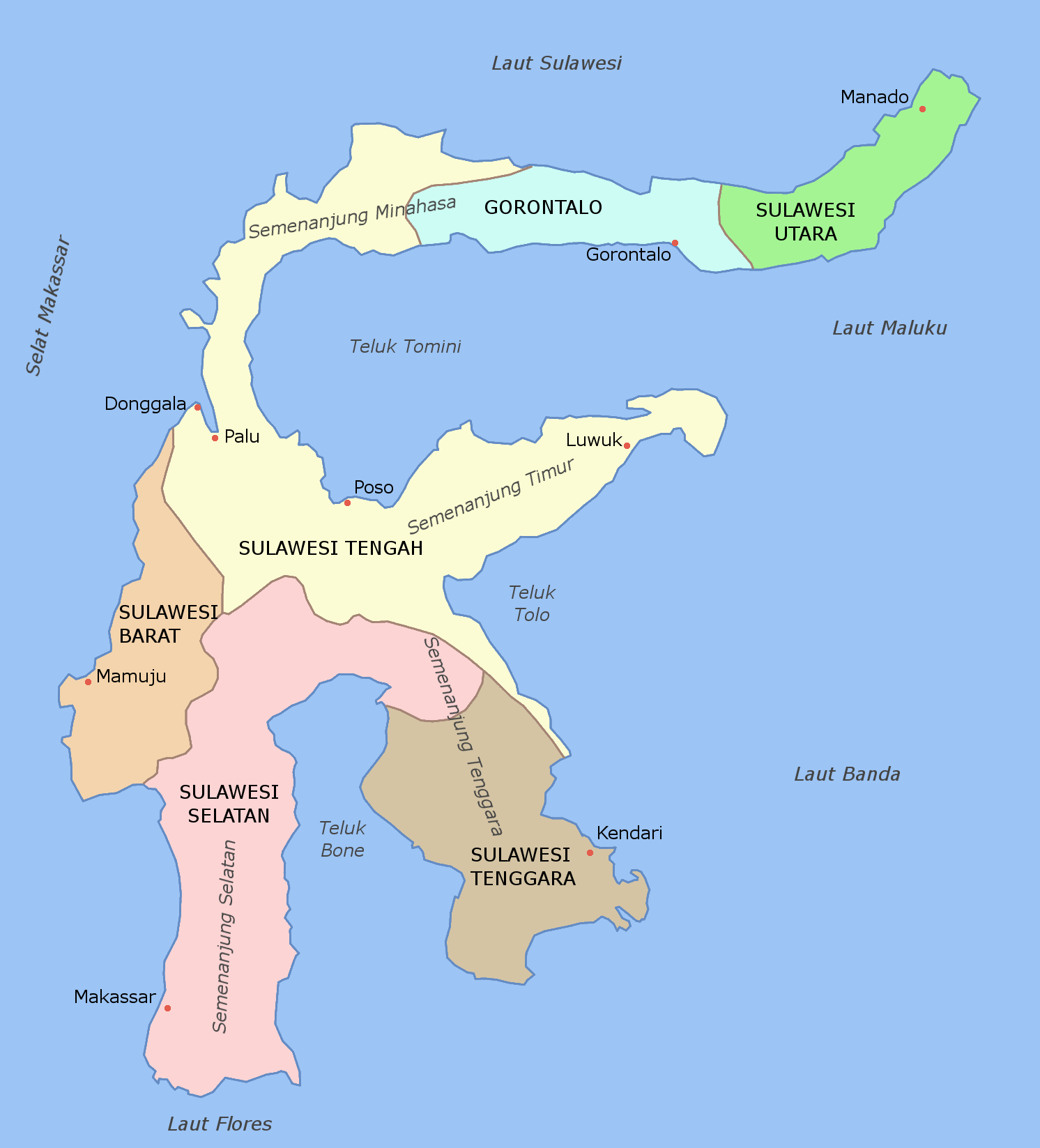
Fitxategi:Sulawesi map id.png
Aurreikuspen honen neurria: 543 × 599 pixel. Bestelako bereizmenak: 217 × 240 pixel | 435 × 480 pixel | 696 × 768 pixel | 928 × 1.024 pixel | 1.492 × 1.647 pixel.
Bereizmen handikoa ((1.492 × 1.647 pixel, fitxategiaren tamaina: 178 KB, MIME mota: image/png))
Fitxategi hau Wikimedia Commonsekoa da. Hango deskribapen orriko informazioa behean duzu. |
| Deskribapena | Map of provinces of Sulawesi labelled in Indonesian |
| Data | (UTC) |
| Jatorria | |
| Egilea |
|
| This is a retouched picture, which means that it has been digitally altered from its original version. Modifications: added Indonesian labels. The original can be viewed here: Sulawesi map.PNG:
|
Fitxategi hau Creative Commons Attribution-Share Alike 3.0 Unported lizentziapean dago.
- Askea zara:
- partekatzeko – lana kopiatzeko, banatzeko eta bidaltzeko
- birnahasteko – lana moldatzeko
- Ondorengo baldintzen pean:
- eskuduntza – Egiletza behar bezala aitortu behar duzu, lizentzia ikusteko esteka gehitu, eta ea aldaketak egin diren aipatu. Era egokian egin behar duzu hori guztia, baina inola ere ez egileak zure lana edo zure erabilera babesten duela irudikatuz.
- berdin partekatu – Lan honetan oinarrituta edo aldatuta berria eraikitzen baduzu, emaitza lana hau bezalako lizentzia batekin argitaratu behar duzu.
Jatorrizko igoera erregistroa
This image is a derivative work of the following images:
- File:Sulawesi_blank.PNG licensed with Cc-by-sa-3.0-migrated, GFDL
- File:Sulawesi_map.PNG licensed with Cc-by-sa-3.0-migrated, GFDL
- 2006-03-11T12:11:53Z Roke 1492x1647 (85249 Bytes) fixed borders of provinces
- 2006-03-11T04:55:05Z Roke 1492x1647 (84460 Bytes) Sulawesi showing provinces, their capital cities, a few other cities and some surrounding areas of water. Note that there are other islands in this area which are not shown as this is a map of Sulawesi island itself. [[Categ
Uploaded with derivativeFX
Fitxategiaren historia
Data/orduan klik egin fitxategiak orduan zuen itxura ikusteko.
| Data/Ordua | Iruditxoa | Neurriak | Erabiltzailea | Iruzkina | |
|---|---|---|---|---|---|
| oraingoa | 14:24, 17 urria 2010 | | 1.492 × 1.647 (178 KB) | Olaf Studt | adjusted Flores Sea position |
| 13:40, 17 urria 2010 |  | 1.492 × 1.647 (178 KB) | Olaf Studt | {{Information |Description=Map of provinces of Category:Sulawesi labelled in Indonesian |Source=*File:Sulawesi_blank.PNG *File:Sulawesi_map.PNG |Date=2010-10-17 11:33 (UTC) |Author=*File:Sulawesi_blank.PNG: User:Roke *[[:File: |
Irudira dakarten loturak
Ez dago fitxategi hau darabilen orririk.
Fitxategiaren erabilera orokorra
Hurrengo beste wikiek fitxategi hau darabilte:
- ba.wikipedia.org proiektuan duen erabilera
- de.wikipedia.org proiektuan duen erabilera
- de.wikivoyage.org proiektuan duen erabilera
- de.wiktionary.org proiektuan duen erabilera
- eo.wikipedia.org proiektuan duen erabilera
- frr.wikipedia.org proiektuan duen erabilera
- pl.wikipedia.org proiektuan duen erabilera
- pl.wiktionary.org proiektuan duen erabilera
- ru.wikipedia.org proiektuan duen erabilera
- szl.wikipedia.org proiektuan duen erabilera