Fitxategi:Spice Islands (Zanzibar highlighted).svg

SVG fitxategi honen PNG aurreikuspenaren tamaina: 486 × 599 pixel. Bestelako bereizmenak: 195 × 240 pixel | 389 × 480 pixel | 623 × 768 pixel | 831 × 1.024 pixel | 1.662 × 2.048 pixel | 512 × 631 pixel.
Bereizmen handikoa (SVG fitxategia, nominaldi 512 × 631 pixel, fitxategiaren tamaina: 6,08 MB)
Fitxategi hau Wikimedia Commonsekoa da. Hango deskribapen orriko informazioa behean duzu. |
.svg)
Laburpena
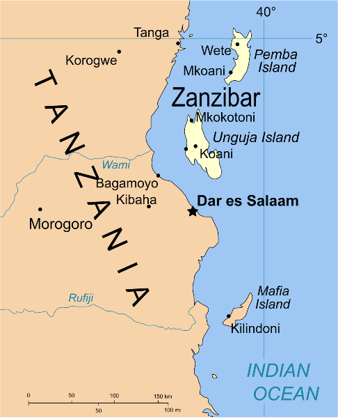
| Deskribapena | Part of the map of Tanzania, showing the Spice Islands, and highlighting Zanzibar. |
| Data | |
| Jatorria | Vectors self-made in Inkscape. Source was cropped from 2003 Political map of Tanzania at Perry-Castañeda Library Map Collection — Tanzania. The maps are attributed to the US Central Intelligence Agency. |
| Egilea | Mysid |
| Beste bertsioak |
Derivative works of this file: Image:Spice Islands (Tanzania).svgin French : Image:Spice_Islands_Tanzania-fr.svg in French : Image:Spice_Islands-Zanzibar_highlighted-fr.svg in Arabic: Image:Spice Islands (Zanzibar highlighted)-ar.svg |
| SVG genesis | Fitxategi hau (bektore-irudia) hau CorelDRAW-ekin sortu da . |
_el.svg)
_sv.svg)
.svg)
-ar.svg)
Lizentzia
| Nik, lan honen egile eskubideen jabeak, lan hau domeinu publikoan jartzen dut. Mundu osoan du eragina honek. Estatu batzuetan beharbada hori ez da legez posible izango. Halakoetan: Edonori ematen diot lan hau edozertarako erabiltzeko eskubidea, inolako baldintzarik gabe, legeak nahitaez ezarritako baldintzak izan ezik. |
Fitxategiaren historia
Data/orduan klik egin fitxategiak orduan zuen itxura ikusteko.
| Data/Ordua | Iruditxoa | Neurriak | Erabiltzailea | Iruzkina | |
|---|---|---|---|---|---|
| oraingoa | 04:16, 9 urria 2021 | | 512 × 631 (6,08 MB) | Nwbeeson | Zanzibar Island renamed to Unguja Island to match article caption |
| 22:09, 6 urtarrila 2007 |  | 713 × 879 (15 KB) | Mysid | higlighting Pemba as well | |
| 22:06, 6 urtarrila 2007 |  | 713 × 879 (15 KB) | Mysid | == Summary == {{Information |Description=Part of the map of Tanzania, showing the Spice Islands, and highlighting Zanzibar. |Source=Vectors self-made in Inkscape. Source was cropped from http://www.lib.utexas.edu/maps/africa/tanzania_p |
Irudira dakarten loturak
Hurrengo orrialdeek dute fitxategi honetarako lotura:
Fitxategiaren erabilera orokorra
Hurrengo beste wikiek fitxategi hau darabilte:
- af.wikipedia.org proiektuan duen erabilera
- ar.wikipedia.org proiektuan duen erabilera
- ast.wikipedia.org proiektuan duen erabilera
- ast.wiktionary.org proiektuan duen erabilera
- azb.wikipedia.org proiektuan duen erabilera
- az.wikipedia.org proiektuan duen erabilera
- ba.wikipedia.org proiektuan duen erabilera
- bg.wikipedia.org proiektuan duen erabilera
- bn.wikipedia.org proiektuan duen erabilera
- br.wikipedia.org proiektuan duen erabilera
- ca.wikipedia.org proiektuan duen erabilera
- cs.wikipedia.org proiektuan duen erabilera
- de.wikipedia.org proiektuan duen erabilera
- en.wikipedia.org proiektuan duen erabilera
- eo.wikipedia.org proiektuan duen erabilera
- fa.wikipedia.org proiektuan duen erabilera
- fiu-vro.wikipedia.org proiektuan duen erabilera
- fr.wikipedia.org proiektuan duen erabilera
- gd.wikipedia.org proiektuan duen erabilera
- gl.wikipedia.org proiektuan duen erabilera
- ha.wikipedia.org proiektuan duen erabilera
- hr.wikipedia.org proiektuan duen erabilera
- hy.wikipedia.org proiektuan duen erabilera
- id.wikipedia.org proiektuan duen erabilera
- it.wikipedia.org proiektuan duen erabilera
- it.wikivoyage.org proiektuan duen erabilera
- ja.wikipedia.org proiektuan duen erabilera
- ka.wikipedia.org proiektuan duen erabilera
- ko.wikipedia.org proiektuan duen erabilera
- ku.wikipedia.org proiektuan duen erabilera
- lt.wikipedia.org proiektuan duen erabilera
- lv.wikipedia.org proiektuan duen erabilera
- mg.wikipedia.org proiektuan duen erabilera
- nl.wikipedia.org proiektuan duen erabilera
Ikus fitxategi honen erabilpen global gehiago.
.svg)
.svg)