Fitxategi:Spice Islands (Tanzania).svg

SVG fitxategi honen PNG aurreikuspenaren tamaina: 486 × 599 pixel. Bestelako bereizmenak: 195 × 240 pixel | 389 × 480 pixel | 623 × 768 pixel | 831 × 1.024 pixel | 1.661 × 2.048 pixel | 713 × 879 pixel.
Bereizmen handikoa (SVG fitxategia, nominaldi 713 × 879 pixel, fitxategiaren tamaina: 15 KB)
Fitxategi hau Wikimedia Commonsekoa da. Hango deskribapen orriko informazioa behean duzu. |
.svg)
Laburpena
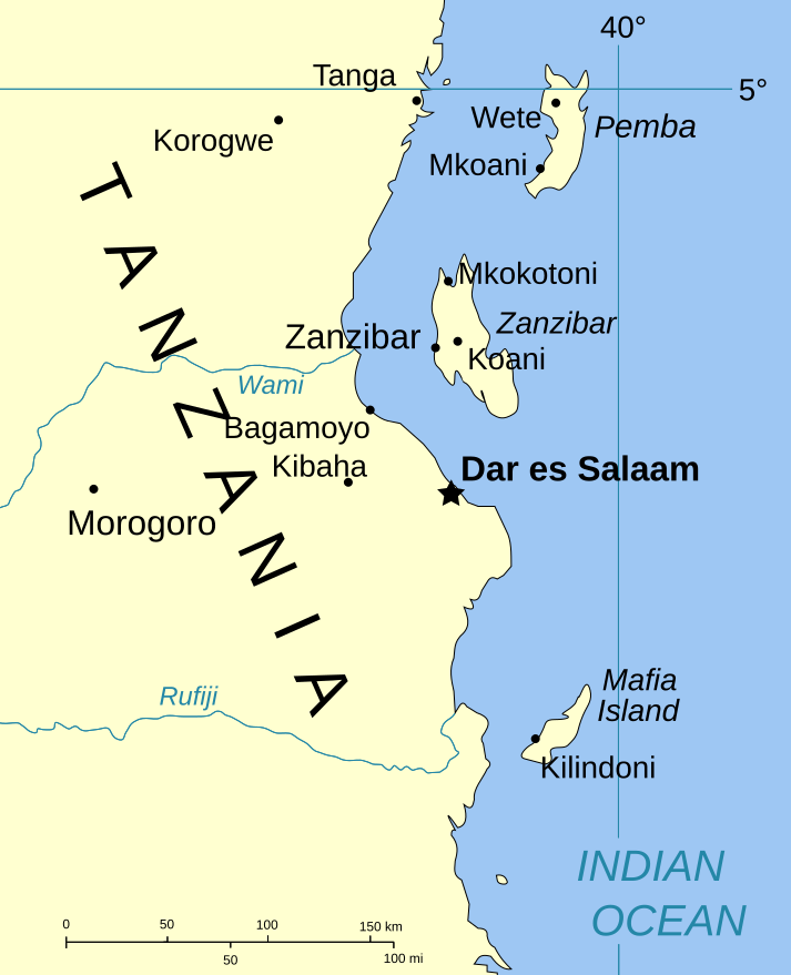
| Deskribapena | Part of the map of Tanzania, showing the Spice Islands. |
| Data | |
| Jatorria | Vectors self-made in Inkscape. Source was cropped from http://www.lib.utexas.edu/maps/africa/tanzania_pol_2003.jpg which is said to be in the public domain in the Perry-Castañeda Map Collection FAQ. |
| Egilea | Mysid |
| Lizentzia (Fitxategi hau berrerabiltzen) |
PD |
| Beste bertsioak |
Image:Spice Islands (Zanzibar highlighted).svg in French : Image:Spice_Islands_Tanzania-fr.svg in French : Image:Spice_Islands-Zanzibar_highlighted-fr.svg |
.svg)
Lizentzia
| Nik, lan honen egile eskubideen jabeak, lan hau domeinu publikoan jartzen dut. Mundu osoan du eragina honek. Estatu batzuetan beharbada hori ez da legez posible izango. Halakoetan: Edonori ematen diot lan hau edozertarako erabiltzeko eskubidea, inolako baldintzarik gabe, legeak nahitaez ezarritako baldintzak izan ezik. |
Fitxategiaren historia
Data/orduan klik egin fitxategiak orduan zuen itxura ikusteko.
| Data/Ordua | Iruditxoa | Neurriak | Erabiltzailea | Iruzkina | |
|---|---|---|---|---|---|
| oraingoa | 22:01, 6 urtarrila 2007 | | 713 × 879 (15 KB) | Mysid | (a bit more) standard colors |
| 08:44, 29 maiatza 2006 |  | 713 × 879 (20 KB) | Mysid | corrected buggy scale | |
| 08:40, 29 maiatza 2006 |  | 713 × 879 (20 KB) | Mysid | New version, exported from CorelDraw (inkscape seems buggy) | |
| 20:23, 28 maiatza 2006 |  | 713 × 893 (37 KB) | Mysid | {{Information |Description=Part of the map of Tanzania, showing the Spice Islands. |Source=Vectors self-made in Inkscape. Source was cropped from http://www.lib.utexas.edu/maps/africa/tanzania_pol_2003.jpg which is said to be in the pu |
Irudira dakarten loturak
Hurrengo orrialdeek dute fitxategi honetarako lotura:
Fitxategiaren erabilera orokorra
Hurrengo beste wikiek fitxategi hau darabilte:
- ckb.wikipedia.org proiektuan duen erabilera
- da.wikipedia.org proiektuan duen erabilera
- eo.wikipedia.org proiektuan duen erabilera
- fa.wikipedia.org proiektuan duen erabilera
- fo.wikipedia.org proiektuan duen erabilera
- fr.wikipedia.org proiektuan duen erabilera
- hr.wikipedia.org proiektuan duen erabilera
- it.wikipedia.org proiektuan duen erabilera
- ja.wikipedia.org proiektuan duen erabilera
- mi.wikipedia.org proiektuan duen erabilera
- nl.wikipedia.org proiektuan duen erabilera
- no.wikipedia.org proiektuan duen erabilera
- pt.wikipedia.org proiektuan duen erabilera
- sr.wikipedia.org proiektuan duen erabilera
- sv.wikipedia.org proiektuan duen erabilera
- vi.wikipedia.org proiektuan duen erabilera
- zh.wikipedia.org proiektuan duen erabilera
.svg)