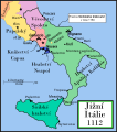
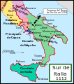
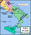
Fitxategi:Southern Italy 1112.svg

SVG fitxategi honen PNG aurreikuspenaren tamaina: 529 × 600 pixel. Bestelako bereizmenak: 212 × 240 pixel | 423 × 480 pixel | 678 × 768 pixel | 903 × 1.024 pixel | 1.807 × 2.048 pixel | 712 × 807 pixel.
Bereizmen handikoa (SVG fitxategia, nominaldi 712 × 807 pixel, fitxategiaren tamaina: 652 KB)
Fitxategiaren historia
Data/orduan klik egin fitxategiak orduan zuen itxura ikusteko.
| Data/Ordua | Iruditxoa | Neurriak | Erabiltzailea | Iruzkina | |
|---|---|---|---|---|---|
| oraingoa | 19:29, 9 urtarrila 2008 |  | 712 × 807 (652 KB) | Salli~commonswiki | |
| 23:12, 16 apirila 2007 |  | 712 × 807 (739 KB) | MapMaster | Slightly modified version | |
| 18:32, 20 abendua 2006 |  | 712 × 807 (739 KB) | MapMaster | Fixed typo, added Taranto | |
| 16:15, 16 abendua 2006 |  | 712 × 807 (729 KB) | MapMaster | A political map of southern Italy in 1112 AD/CE, the date when Roger II of Sicily reached his age of majority. |
Irudira dakarten loturak
Hurrengo orrialdeek dute fitxategi honetarako lotura:
Fitxategiaren erabilera orokorra
Hurrengo beste wikiek fitxategi hau darabilte:
- ar.wikipedia.org proiektuan duen erabilera
- azb.wikipedia.org proiektuan duen erabilera
- bg.wikipedia.org proiektuan duen erabilera
- cs.wikipedia.org proiektuan duen erabilera
- da.wikipedia.org proiektuan duen erabilera
- de.wikipedia.org proiektuan duen erabilera
- el.wikipedia.org proiektuan duen erabilera
- en.wikipedia.org proiektuan duen erabilera
- Manuel I Komnenos
- Roger II of Sicily
- List of historical states of Italy
- Southern Italy
- Duchy of Naples
- Jordan II of Capua
- Robert II of Capua
- Alfonso of Capua
- Ranulf II of Alife
- Battle of Nocera
- Sergius VII of Naples
- Battle of Rignano
- User:MapMaster
- Byzantine–Norman wars
- County of Sicily
- County of Apulia and Calabria
- 1137 in Italy
- Bianco d'Alessano
- Cesina family
- et.wikipedia.org proiektuan duen erabilera
- fa.wikipedia.org proiektuan duen erabilera
- fi.wikipedia.org proiektuan duen erabilera
- hu.wikipedia.org proiektuan duen erabilera
Ikus fitxategi honen erabilpen global gehiago.


