Fitxategi:Somalia Numbered Regions.png
Aurreikuspen honen neurria: 480 × 600 pixel. Bestelako bereizmenak: 192 × 240 pixel | 512 × 640 pixel.
Bereizmen handikoa ((512 × 640 pixel, fitxategiaren tamaina: 20 KB, MIME mota: image/png))
Fitxategi hau Wikimedia Commonsekoa da. Hango deskribapen orriko informazioa behean duzu. |
| Deskribapena |
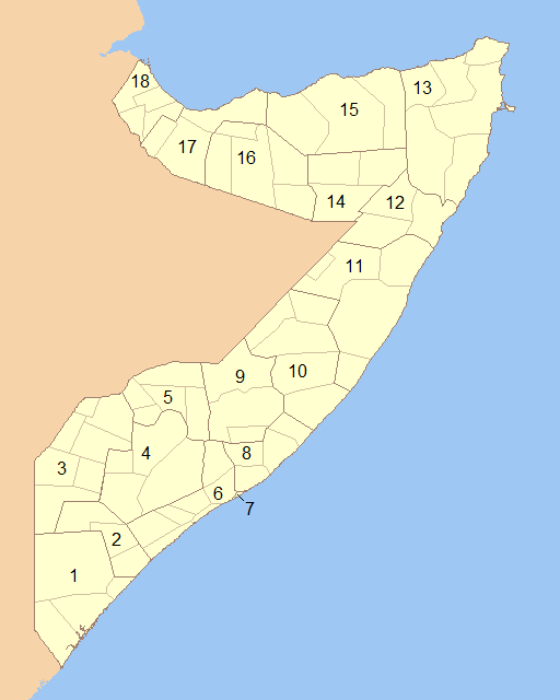
English: Blank map of Somalia showing the regions (numbered) and districts in detail together. 1- Lower Juba 2- Middle Juba 3- Gedo 4- Bay 5- Bakool 6- Lower Shabele 7- Banaadir 8- Middle Shabele 9- Hiiraan 10- Galguduud 11- Mudug 12- Nugaal 13- Bari 14- Sool 15- Sanaag 16- Togdheer 17- Woqooyi Galbeed 18- Awdal |
||
| Data | |||
| Jatorria | Modified File:Somalia Regions and Districts.png to create image | ||
| Egilea | Wiz9999 | ||
| Lizentzia (Fitxategi hau berrerabiltzen) |
|
||
| Beste bertsioak | File:Somalia Regions and Districts.png |
Fitxategiaren historia
Data/orduan klik egin fitxategiak orduan zuen itxura ikusteko.
| Data/Ordua | Iruditxoa | Neurriak | Erabiltzailea | Iruzkina | |
|---|---|---|---|---|---|
| oraingoa | 02:13, 6 ekaina 2009 | | 512 × 640 (20 KB) | Wiz9999 | {{Information |Description={{en|1=Blank map of Somalia showing the regions (numbered) and districts in detail together.}} |Source=Modified File:Somalia Regions and Districts.png to create image |Author=Wiz9999 |Date=2009-06-05 |Permi |
Irudira dakarten loturak
Hurrengo orrialdeek dute fitxategi honetarako lotura:
Fitxategiaren erabilera orokorra
Hurrengo beste wikiek fitxategi hau darabilte:
- als.wikipedia.org proiektuan duen erabilera
- ar.wikipedia.org proiektuan duen erabilera
- azb.wikipedia.org proiektuan duen erabilera
- bg.wikipedia.org proiektuan duen erabilera
- bs.wikipedia.org proiektuan duen erabilera
- da.wikipedia.org proiektuan duen erabilera
- de.wikipedia.org proiektuan duen erabilera
- el.wikipedia.org proiektuan duen erabilera
- en.wikipedia.org proiektuan duen erabilera
- es.wikipedia.org proiektuan duen erabilera
- fa.wikipedia.org proiektuan duen erabilera
- is.wikipedia.org proiektuan duen erabilera
- it.wikipedia.org proiektuan duen erabilera
- ko.wikipedia.org proiektuan duen erabilera
- li.wikipedia.org proiektuan duen erabilera
- mk.wikipedia.org proiektuan duen erabilera
- mzn.wikipedia.org proiektuan duen erabilera
- no.wikipedia.org proiektuan duen erabilera
- pl.wikipedia.org proiektuan duen erabilera
- ps.wikipedia.org proiektuan duen erabilera
- pt.wikipedia.org proiektuan duen erabilera
- ro.wikipedia.org proiektuan duen erabilera
- ru.wikipedia.org proiektuan duen erabilera
- so.wikipedia.org proiektuan duen erabilera
- trv.wikipedia.org proiektuan duen erabilera
- tr.wikipedia.org proiektuan duen erabilera
- ur.wikipedia.org proiektuan duen erabilera
- zh-classical.wikipedia.org proiektuan duen erabilera
- zh.wikipedia.org proiektuan duen erabilera