Fitxategi:Snow-cholera-map-1.jpg

Bereizmen handikoa ((20.124 × 18.877 pixel, fitxategiaren tamaina: 18,38 MB, MIME mota: image/jpeg))
Fitxategi hau Wikimedia Commonsekoa da. Hango deskribapen orriko informazioa behean duzu. |
Laburpena
| Warning | The original file is very high-resolution. It might not load properly or could cause your browser to freeze when opened at full size. |
|---|
| Deskripzio |
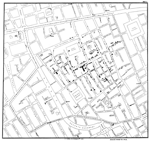
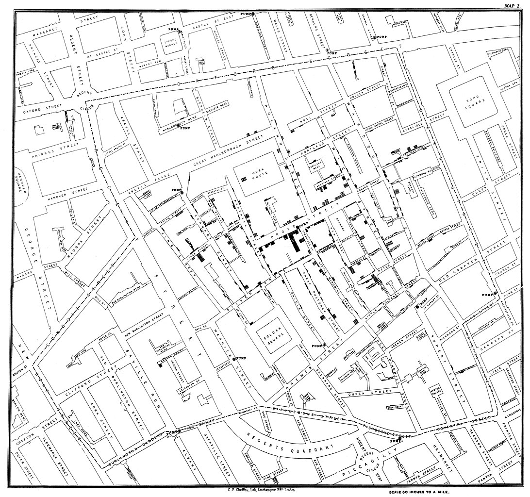
Original map made by John Snow in 1854. Cholera cases are highlighted in black, showing the clusters of cholera cases (indicated by stacked rectangles) in the London epidemic of 1854. The map was created in order to better understand the pattern of cholera spread in the 1854 Broad Street cholera outbreak, which Snow would use as an example of how cholera spread via the fecal-oral route through water systems as opposed to the miasma theory of disease spread. The contaminated pump is located at the intersection of Broad Street and Cambridge Street (now Lexington Street), running into Little Windmill Street. The map marks an important part of the development of epidemiology as a field, and of disease mapping as a whole. |
|||||||||||||||||
| Data | ||||||||||||||||||
| Jatorria |
Map of the book "On the Mode of Communication of Cholera" by John Snow, originally published in 1854 by C.F. Cheffins, Lith, Southhampton Buildings, London, England. The uploaded images is a digitally enhanced version found on the UCLA Department of Epidemiology website. |
|||||||||||||||||
| Sortzailea |
|
|||||||||||||||||
| Geotemporal data | ||||||||||||||||||
| Bounding box |
|
|||||||||||||||||
| Georeferencing | ||||||||||||||||||
| Beste bertsioak | File:Snow-cholera-map.jpg | |||||||||||||||||

|
Lizentzia
|
Honoko hau, domeinu publikoan dagoen bi dimentsioko artelan baten argazki-erreprodukzio fidela da. Artelana domeinu publikoan dago ondoko arrazoi hauengatik:
Wikimedia Fundazioak duen jarrera ofiziala hau da:«domeinu publikoan dauden bi dimentsioko erreprodukzio fidelak domeinu publikokoak dira.»
Argazki-erreprodukzio hau, beraz, domeinu publikokotzat hartzen da Estatu Batuetan. Beste jurisdikzio batzuetan eduki honen berrerabilera mugatua egon liteke; xehetasunetarako, ikus Reuse of PD-Art photographs. | ||||
Jatorrizko igoera erregistroa
(All user names refer to en.wikipedia)
- 2006-12-30 23:15 Rewardiv 3045×2840×8 (1183741 bytes) Original map made by John Snow in 1854, copied from http://matrix.msu.edu/~johnsnow/images/online_companion/chapter_images/fig12-5.jpg Author died in 1858, material is public domain.
Fitxategiaren historia
Data/orduan klik egin fitxategiak orduan zuen itxura ikusteko.
| Data/Ordua | Iruditxoa | Neurriak | Erabiltzailea | Iruzkina | |
|---|---|---|---|---|---|
| oraingoa | 23:19, 16 azaroa 2020 | | 20.124 × 18.877 (18,38 MB) | Artoria2e5 | Reverted to version as of 14:12, 6 May 2020 (UTC) |
| 23:12, 16 azaroa 2020 |  | 1.092 × 1.024 (320 KB) | Artoria2e5 | temporarily reduce size for wikimaps | |
| 16:12, 6 maiatza 2020 |  | 20.124 × 18.877 (18,38 MB) | Sette-quattro | higher resolution version | |
| 15:53, 22 ekaina 2007 |  | 3.045 × 2.840 (1,13 MB) | Finavon | {{Information |Description=Original map made by John Snow in 1854, copied from http://matrix.msu.edu/~johnsnow/images/online_companion/chapter_images/fig12-5.jpg Author died in 1858, material is public domain. |Source=Originally from [http://en.wikipedi |
Irudira dakarten loturak
Hurrengo orrialdeek dute fitxategi honetarako lotura:
Fitxategiaren erabilera orokorra
Hurrengo beste wikiek fitxategi hau darabilte:
- ar.wikipedia.org proiektuan duen erabilera
- bg.wikipedia.org proiektuan duen erabilera
- bh.wikipedia.org proiektuan duen erabilera
- bn.wikipedia.org proiektuan duen erabilera
- ca.wikipedia.org proiektuan duen erabilera
- de.wikipedia.org proiektuan duen erabilera
- en.wikipedia.org proiektuan duen erabilera
- Human geography
- Natural experiment
- Water purification
- Public health
- John Snow
- Slow sand filter
- Portal:Medicine
- Health geography
- Thematic map
- User talk:Mathwhiz 29
- Statistical graphics
- Wikipedia:Featured pictures/Diagrams, drawings, and maps/Maps
- 1846–1860 cholera pandemic
- 1854 Broad Street cholera outbreak
- Talk:1854 Broad Street cholera outbreak
- User:Aetarrell/Practice
- GIS and public health
- Wikipedia:WikiProject Medicine/Recognized content
- Dot distribution map
- History of water filters
- Wikipedia:Reference desk/Archives/Humanities/2010 August 24
- History of water supply and sanitation
- User talk:Sarason
- Portal:Geography/Intro/Image
- User talk:Smileguy91
- User:Life in General/Userboxes/HumanGeography
- User talk:Gwooodward
- Portal:Geography/Intro/6
- User:Wouterstomp/test
- Charles Cheffins
- User talk:Khamar
- User talk:Joshualouie711
- User talk:OfficialNeon
- User talk:Sahara4u/Archive 5
- User talk:Tyrone Madera
Ikus fitxategi honen erabilpen global gehiago.