Fitxategi:Schengen Area.svg

SVG fitxategi honen PNG aurreikuspenaren tamaina: 454 × 450 pixel. Bestelako bereizmenak: 242 × 240 pixel | 484 × 480 pixel | 775 × 768 pixel | 1.033 × 1.024 pixel | 2.066 × 2.048 pixel.
Bereizmen handikoa (SVG fitxategia, nominaldi 454 × 450 pixel, fitxategiaren tamaina: 403 KB)
Fitxategi hau Wikimedia Commonsekoa da. Hango deskribapen orriko informazioa behean duzu. |
Laburpena
| Deskribapena |
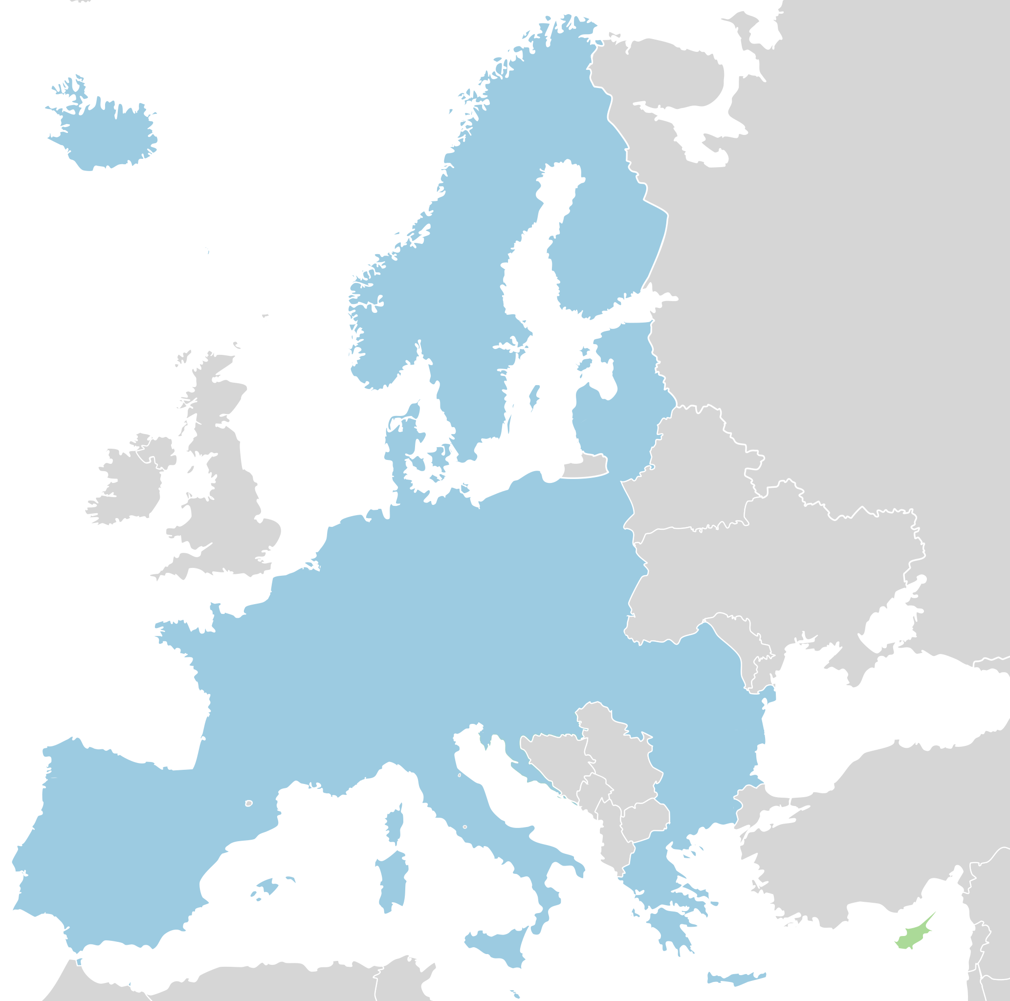
English: Map of the Schengen Area.
|
| Data | (UTC) |
| Jatorria |
|
| Egilea |
|
Lizentzia
Nik, lan honen egileak, argitaratzen dut ondorengo lizentzia hauen pean:
This file is licensed under the Creative Commons Attribution-Share Alike 3.0 Unported, 2.5 Generic, 2.0 Generic and 1.0 Generic license.
- Askea zara:
- partekatzeko – lana kopiatzeko, banatzeko eta bidaltzeko
- birnahasteko – lana moldatzeko
- Ondorengo baldintzen pean:
- eskuduntza – Egiletza behar bezala aitortu behar duzu, lizentzia ikusteko esteka gehitu, eta ea aldaketak egin diren aipatu. Era egokian egin behar duzu hori guztia, baina inola ere ez egileak zure lana edo zure erabilera babesten duela irudikatuz.
- berdin partekatu – Lan honetan oinarrituta edo aldatuta berria eraikitzen baduzu, emaitza lana hau bezalako lizentzia batekin argitaratu behar duzu.

|
Baimena duzu dokumentu hau kopiatu, banatu edo/eta aldatzeko GNU Free Documentation License baldintzapean, Free Software Foundationek argitaratutako 1.2 edo ondorengo bertsioan; sekzio aldaezinik gabe, azaleko testurik gabe, eta atzeko azaleko testurik gabe. Lizentziaren kopia dago GNU Free Documentation License izenburudun atalean. |
Nahiago duzun lizentzia erabil dezakezu.
Jatorrizko igoera erregistroa
This image is a derivative work of the following images:
- File:Schengen_Agreement_map.svg licensed with Cc-by-sa-3.0,2.5,2.0,1.0, GFDL
- 2010-08-07T19:43:03Z Fry1989 454x450 (535167 Bytes) Reverted to version as of 13:34, 12 December 2008 bacl to brown, Ireland and UK both apply a few Shengen laws, but are brown because they have a seperate border treaty with eachother called the Common Travel Area
- 2010-08-07T15:30:51Z Blue-Haired Lawyer 454x450 (535167 Bytes) The Republic of Ireland has never ratified police and judicial cooperation agreement
- 2008-12-12T13:34:41Z Bourrichon 454x450 (535167 Bytes) + Suisse
- 2008-11-07T10:03:38Z Ssolbergj 454x450 (540728 Bytes) New colour for UK and Ireland
- 2008-01-21T20:55:08Z Ssolbergj 454x450 (540416 Bytes) {{Information |Description= |Source= |Date= |Author= |Permission= |other_versions= }}
- 2008-01-02T13:03:06Z Ssolbergj 454x450 (539135 Bytes) Serbia-Kosovo border removed. For now.
- 2007-12-17T18:01:15Z Ssolbergj 454x450 (540214 Bytes)
- 2007-12-17T17:52:27Z Ssolbergj 454x450 (540206 Bytes) {{Information |Description=Schengen Agreement |Source=self-made |Date=17/12/07 |Author= [[User:Ssolbergj|Ssolbergj]] |Permission= |other_versions= }}
Uploaded with derivativeFX
Fitxategiaren historia
Data/orduan klik egin fitxategiak orduan zuen itxura ikusteko.
| Data/Ordua | Iruditxoa | Neurriak | Erabiltzailea | Iruzkina | |
|---|---|---|---|---|---|
| oraingoa | 16:29, 2 apirila 2024 | | 454 × 450 (403 KB) | Palu | Bulgaria and Romania joined Schengen |
| 12:19, 1 urtarrila 2023 |  | 454 × 450 (402 KB) | Honza9513 | new borders (Croatia) | |
| 15:14, 9 abendua 2022 |  | 454 × 450 (368 KB) | Iktsokh | Correction of borders | |
| 16:15, 25 ekaina 2018 |  | 454 × 450 (517 KB) | Fobos92 | Reverted to version as of 22:39, 17 June 2015 (UTC) | |
| 03:55, 23 abuztua 2015 |  | 1.300 × 1.300 (7,36 MB) | Mattflaschen | Malta is now part of the Schengen Area. | |
| 00:40, 18 ekaina 2015 |  | 1.300 × 1.300 (7,32 MB) | Rob984 | Improved version without new colours. | |
| 00:39, 18 ekaina 2015 |  | 454 × 450 (517 KB) | Rob984 | Actually I will upload a new file with more colours. | |
| 00:35, 18 ekaina 2015 |  | 1.300 × 1.300 (7,33 MB) | Rob984 | Higher quality version derived from File:Location European nation states.svg. +Showing non-EU members in a darker blue. | |
| 23:17, 29 iraila 2014 |  | 454 × 450 (517 KB) | Thayts | Added Monaco and circled microstates for better visibility | |
| 00:58, 3 urria 2013 |  | 454 × 450 (523 KB) | Soffredo | Andorra has closed borders according to article |
Irudira dakarten loturak
Hurrengo orrialdeek dute fitxategi honetarako lotura:
Fitxategiaren erabilera orokorra
Hurrengo beste wikiek fitxategi hau darabilte:
- ar.wikipedia.org proiektuan duen erabilera
- arz.wikipedia.org proiektuan duen erabilera
- ast.wikipedia.org proiektuan duen erabilera
- be-tarask.wikipedia.org proiektuan duen erabilera
- ca.wikipedia.org proiektuan duen erabilera
- cs.wikipedia.org proiektuan duen erabilera
- da.wikipedia.org proiektuan duen erabilera
- de.wikipedia.org proiektuan duen erabilera
- el.wikipedia.org proiektuan duen erabilera
- en.wikipedia.org proiektuan duen erabilera
- es.wikipedia.org proiektuan duen erabilera
- es.wikivoyage.org proiektuan duen erabilera
- he.wikivoyage.org proiektuan duen erabilera
- hi.wikipedia.org proiektuan duen erabilera
- incubator.wikimedia.org proiektuan duen erabilera
- it.wikiversity.org proiektuan duen erabilera
- ja.wikipedia.org proiektuan duen erabilera
- jv.wikipedia.org proiektuan duen erabilera
- kn.wikipedia.org proiektuan duen erabilera
- li.wikipedia.org proiektuan duen erabilera
- www.mediawiki.org proiektuan duen erabilera
- ne.wikipedia.org proiektuan duen erabilera
- no.wikipedia.org proiektuan duen erabilera
- os.wikipedia.org proiektuan duen erabilera
- pnb.wikipedia.org proiektuan duen erabilera
- pt.wikipedia.org proiektuan duen erabilera
- ro.wikipedia.org proiektuan duen erabilera
- ru.wikinews.org proiektuan duen erabilera
- scn.wikipedia.org proiektuan duen erabilera
- sc.wikipedia.org proiektuan duen erabilera
- sh.wikipedia.org proiektuan duen erabilera
- simple.wikipedia.org proiektuan duen erabilera
- sl.wikipedia.org proiektuan duen erabilera
- sr.wikipedia.org proiektuan duen erabilera
- ta.wikipedia.org proiektuan duen erabilera
- th.wikipedia.org proiektuan duen erabilera
- tr.wikipedia.org proiektuan duen erabilera
- uk.wikipedia.org proiektuan duen erabilera
- yi.wikipedia.org proiektuan duen erabilera
Ikus fitxategi honen erabilpen global gehiago.