Fitxategi:Routes of European explorers in Africa, to 1853.jpg

Bereizmen handikoa ((1.466 × 2.041 pixel, fitxategiaren tamaina: 1,11 MB, MIME mota: image/jpeg))
Fitxategi hau Wikimedia Commonsekoa da. Hango deskribapen orriko informazioa behean duzu. |
Laburpena
| Deskribapena |
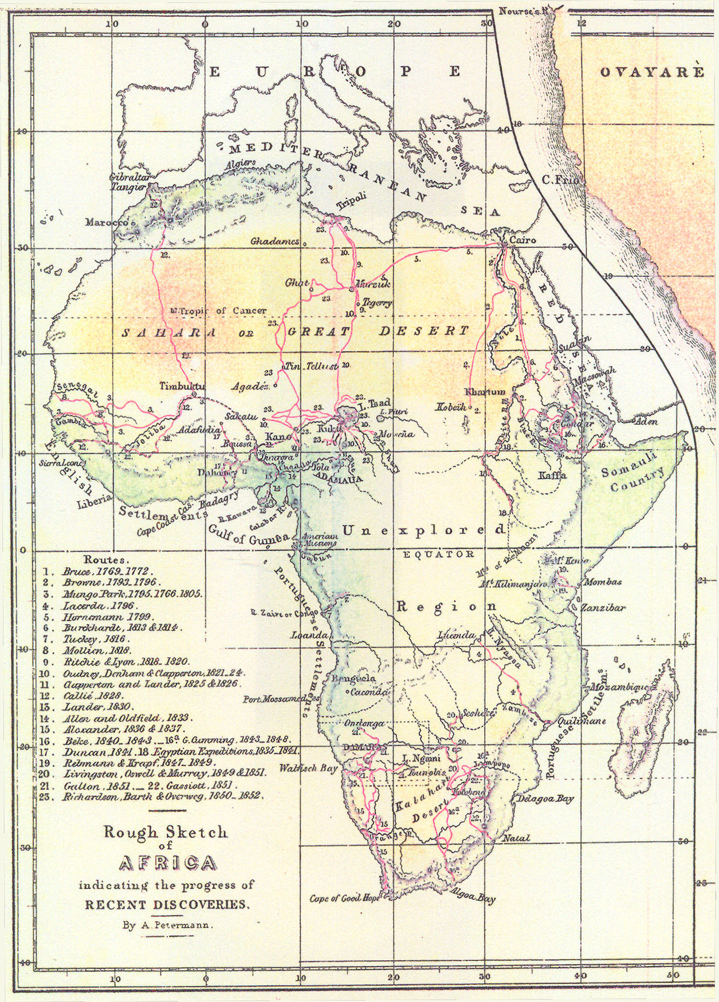
English: "Rough Sketch of Africa indicating the progress of recent discoveries"
See also File:Heinrich Barth's route through Africa, 1850 to 1855, with routes of previous explorers.jpg for another similar map. Routes are shown for the journeys of the following explorers: |
| Data | |
| Jatorria | The map was published as an inset, as the left-hand side of a larger "Map of Damara Land and the Adjacent Countries as explored and surveyed by Francis Galton Esq", published in London by John Murray Ltd in 1854. Part of the larger map can be seen in the top-right of the present image. A thumbnail of the whole map can be seen on the Royal Geographical Society website, image S0016683 |
| Egilea | August Heinrich Petermann |
Lizentzia
This media file is in the public domain in the United States. This applies to U.S. works where the copyright has expired, often because its first publication occurred prior to January 1, 1929, and if not then due to lack of notice or renewal. See this page for further explanation.
|
 | |
 |
This image might not be in the public domain outside of the United States; this especially applies in the countries and areas that do not apply the rule of the shorter term for US works, such as Canada, Mainland China (not Hong Kong or Macao), Germany, Mexico, and Switzerland. The creator and year of publication are essential information and must be provided. See Wikipedia:Public domain and Wikipedia:Copyrights for more details.
|
Fitxategiaren historia
Data/orduan klik egin fitxategiak orduan zuen itxura ikusteko.
| Data/Ordua | Iruditxoa | Neurriak | Erabiltzailea | Iruzkina | |
|---|---|---|---|---|---|
| oraingoa | 17:04, 19 urtarrila 2014 | | 1.466 × 2.041 (1,11 MB) | Jheald | User created page with UploadWizard |
Irudira dakarten loturak
Hurrengo orrialdeek dute fitxategi honetarako lotura:
Fitxategiaren erabilera orokorra
Hurrengo beste wikiek fitxategi hau darabilte:
- bn.wikipedia.org proiektuan duen erabilera
- ca.wikipedia.org proiektuan duen erabilera
- en.wikipedia.org proiektuan duen erabilera
- eo.wikipedia.org proiektuan duen erabilera
- es.wikipedia.org proiektuan duen erabilera
- fa.wikipedia.org proiektuan duen erabilera
- fr.wikipedia.org proiektuan duen erabilera
- gl.wikipedia.org proiektuan duen erabilera
- ha.wikipedia.org proiektuan duen erabilera
- pt.wikipedia.org proiektuan duen erabilera
- ro.wikipedia.org proiektuan duen erabilera
- ru.wikipedia.org proiektuan duen erabilera