Fitxategi:Roman-Empire 477ad.jpg
Bereizmen handikoa ((1.405 × 954 pixel, fitxategiaren tamaina: 372 KB, MIME mota: image/jpeg))
Fitxategi hau Wikimedia Commonsekoa da. Hango deskribapen orriko informazioa behean duzu. |

|
Irudi hau birsortu beharko litzateke SVG irudi bektorial moduan. Honek abantaila asko ematen ditu, ikus Commons:Media for cleanup (ingelesez) informazio gehiagorako. Irudi honen SVG bertsioa eskuragarri badago, mesedez Commonsera igo. Igo ostean, ordezkatu txantiloi hau txantiloi honegatik {{vector version available|irudiaren izen berria.svg}} irudi honetan.
|


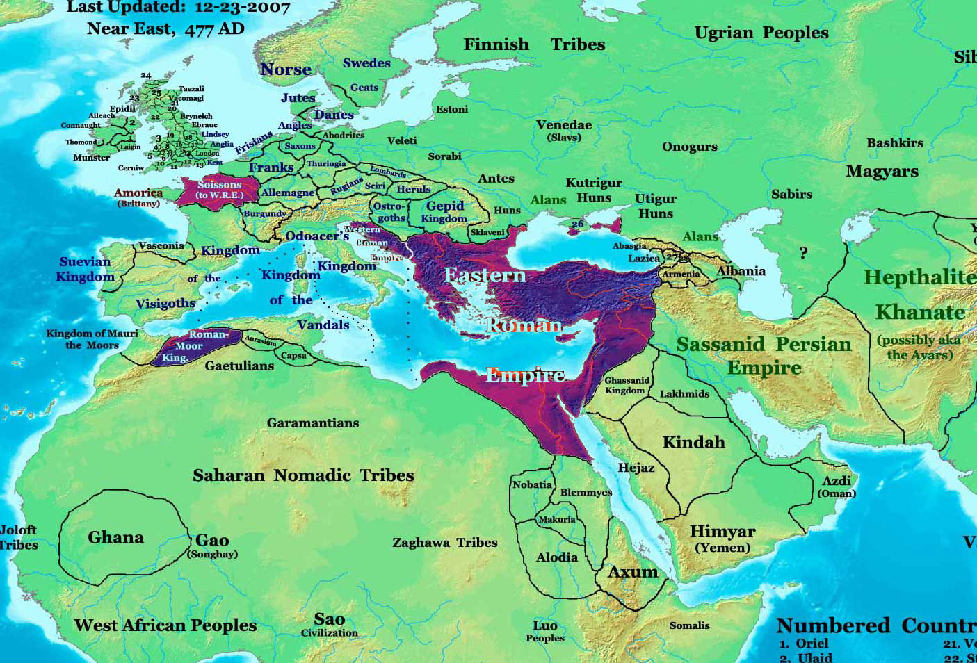
| Deskribapena | The Roman Empire in 477 AD. |
| Data | |
| Jatorria | Norberak egina |
| Egilea | Thomas Lessman (Contact!) |
| Lizentzia (Fitxategi hau berrerabiltzen) |
Nik, lan honen egileak, argitaratzen dut ondorengo lizentzia pean: Fitxategi hau Creative Commons Attribution-Share Alike 3.0 Unported lizentziapean dago.
|
| Beste bertsioak | See Below |
Laburpena
Map Summary
Original Source URL: http://www.thomaslessman.com/History/images/East-Hem_477ad.jpg or www.WorldHistoryMaps.info

This map of the Roman Empire in 477 AD is a zoomed-in version of Thomas Lessman's map of the
East-Hem 477 AD, also available at www.WorldHistoryMaps.info.
The highlighted lands remained under Roman control after the fall of Italy to Odoacer in 476 AD.
- These remnants include the Eastern Roman (Byzantine) Empire, the Domain of Soissons in Gaul, and the Kingdom of the Romans & Moors in north Africa.
Map Source References
Remember, sources often conflict with each other. This map is only as accurate as the information that is available to me. To report any errors or to help further this work, please click here, or email Thomas Lessman at talessman@yis.us
References for information contained in this map:
Other Maps by Thomas Lessman
| Maps of the eastern hemisphere showing history
Bold dates are available on Wikimedia or Wikipedia. | ||
| Primeval | ||
| Ancient
|
·| 600 BC | 550 BC | 527 BC | 500 BC |
400 BC | ·| 1 AD | 50 AD | 100 AD | 200 AD | 300 AD | | |
| Medieval |
·| 500 AD | 565 AD | 600 AD | 700 AD | | |
| Modern |
·| 1500 AD | · * For historical maps of the whole world, | |
Other Info
Fitxategiaren historia
Data/orduan klik egin fitxategiak orduan zuen itxura ikusteko.
| Data/Ordua | Iruditxoa | Neurriak | Erabiltzailea | Iruzkina | |
|---|---|---|---|---|---|
| oraingoa | 11:42, 10 maiatza 2008 | | 1.405 × 954 (372 KB) | Talessman | {{Information |Description='''The Roman Empire in 477 AD.''' (See info below) |Author=Thomas Lessman |Permission={{self|cc-by-sa-3.0}} }} |
Irudira dakarten loturak
Hurrengo orrialdeek dute fitxategi honetarako lotura:
Fitxategiaren erabilera orokorra
Hurrengo beste wikiek fitxategi hau darabilte:
- azb.wikipedia.org proiektuan duen erabilera
- en.wikipedia.org proiektuan duen erabilera
- es.wikipedia.org proiektuan duen erabilera
- hy.wikipedia.org proiektuan duen erabilera
- hyw.wikipedia.org proiektuan duen erabilera
- id.wikipedia.org proiektuan duen erabilera
- it.wikipedia.org proiektuan duen erabilera
- ka.wikipedia.org proiektuan duen erabilera
- ko.wikipedia.org proiektuan duen erabilera
- no.wikipedia.org proiektuan duen erabilera
- pl.wikipedia.org proiektuan duen erabilera
- pt.wikipedia.org proiektuan duen erabilera
- ru.wikipedia.org proiektuan duen erabilera
- sv.wikipedia.org proiektuan duen erabilera
- vi.wikipedia.org proiektuan duen erabilera
- zh.wikipedia.org proiektuan duen erabilera