Fitxategi:Rade de Lorient topographic map-fr.svg

Bereizmen handikoa (SVG fitxategia, nominaldi 3.539 × 3.506 pixel, fitxategiaren tamaina: 1,34 MB)
Fitxategi hau Wikimedia Commonsekoa da. Hango deskribapen orriko informazioa behean duzu. |
Laburpena
| Kameraren kokapena | | Irudi hau eta gehiago beraien kokapenekin hurrengo lekuetan: OpenStreetMap |
|---|
| Deskribapena |
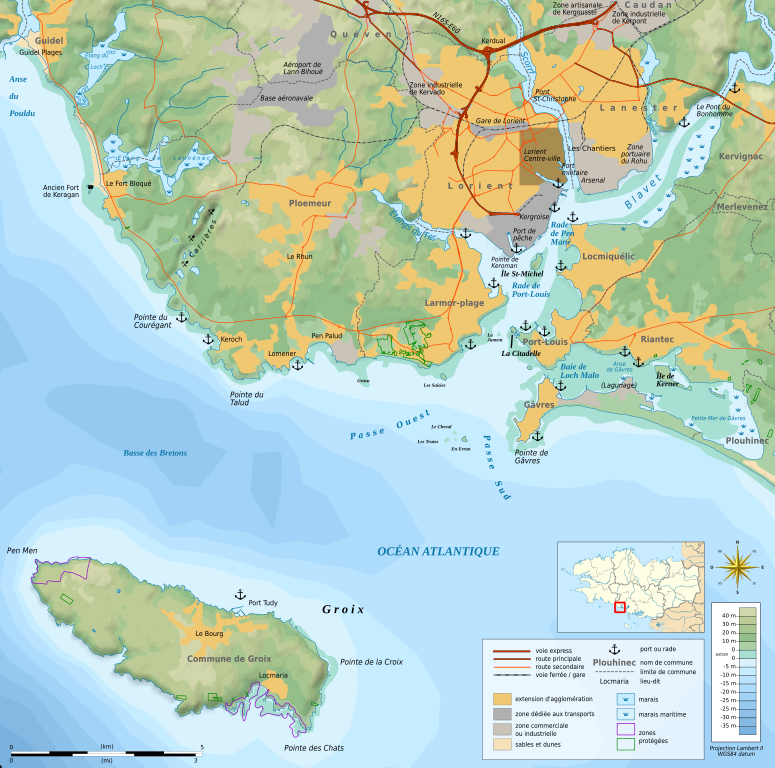
Français : Carte topographique et administrative en français de la rade de Lorient, montrant la ville de Lorient, l'île de Groix et, entre les deux, l'entrée de la rade avec les passes Ouest et Sud. Les deux passes sont séparées par des bas-fonds rocheux des Courreaux de Groix. La carte montre aussi la Petite Mer de Gâvres, l'embouchure du Blavet et l'aéroport de Lann Bihoué.
Deutsch: Topographische Karte / Straßenkarte der Île de Groix und der Stadt Lorient (Bretagne, in Französische.
日本語: フランス語で表示したロリアンの地形図。
|
||
| Data | (UTC) | ||
| Jatorria |
Création personnelle ;
données de la carte © les contributeurs d'OpenStreetMap, CC-BY-SA Openstreetmap via Cloudmade ;
|
||
| Egilea | © Bourrichon (talk) - fr:Bourrichon | ||
| Lizentzia (Fitxategi hau berrerabiltzen) |
|
||
| Beste bertsioak |
Add-your-version : Template:Other versions/Rade de Lorient map Template:Other versions/Rade de Lorient map |
Lizentzia

|
Baimena duzu dokumentu hau kopiatu, banatu edo/eta aldatzeko GNU Free Documentation License baldintzapean, Free Software Foundationek argitaratutako 1.2 edo ondorengo bertsioan; sekzio aldaezinik gabe, azaleko testurik gabe, eta atzeko azaleko testurik gabe. Lizentziaren kopia dago GNU Free Documentation License izenburudun atalean. |
- Askea zara:
- partekatzeko – lana kopiatzeko, banatzeko eta bidaltzeko
- birnahasteko – lana moldatzeko
- Ondorengo baldintzen pean:
- eskuduntza – Egiletza behar bezala aitortu behar duzu, lizentzia ikusteko esteka gehitu, eta ea aldaketak egin diren aipatu. Era egokian egin behar duzu hori guztia, baina inola ere ez egileak zure lana edo zure erabilera babesten duela irudikatuz.
- berdin partekatu – Lan honetan oinarrituta edo aldatuta berria eraikitzen baduzu, emaitza lana hau bezalako lizentzia batekin argitaratu behar duzu.

|
SVG fitxategi honek Inkscape edo Adobe Illustrator bezalako SVG editore bat erabiliz erraz itzul daitekeen barneratutako testua du. Argibide gehiago. Nahi izanez gero, fitxategia jaitsi eta testu editore bat erabiliz ere itzul dezakezu. |
Fitxategiaren historia
Data/orduan klik egin fitxategiak orduan zuen itxura ikusteko.
| Data/Ordua | Iruditxoa | Neurriak | Erabiltzailea | Iruzkina | |
|---|---|---|---|---|---|
| oraingoa | 19:31, 9 otsaila 2013 | | 3.539 × 3.506 (1,34 MB) | Bourrichon | |
| 17:48, 9 otsaila 2013 |  | 3.539 × 3.506 (1,34 MB) | Bourrichon | correction emplacement port de Locmikelic | |
| 14:22, 8 abuztua 2012 |  | 3.539 × 3.506 (1,34 MB) | Bourrichon | m | |
| 14:15, 8 abuztua 2012 |  | 3.539 × 3.506 (1,34 MB) | Bourrichon | +arsenal Kergroise, Rohu | |
| 14:07, 8 abuztua 2012 |  | 3.539 × 3.506 (1,34 MB) | Bourrichon | bug typo | |
| 14:00, 8 abuztua 2012 |  | 3.539 × 3.506 (1,34 MB) | Bourrichon | ||
| 13:54, 8 abuztua 2012 |  | 3.539 × 3.506 (1,34 MB) | Bourrichon | == {{int:filedesc}} == {{Location|47|42|37|N|03|21|49|W|scale:500000}} {{Information |Description= {{fr|Carte topographique et administrative en français de la fr:rade de Lorient, montrant la ville de fr:Lorient, l'île de fr:Groix e... |
Irudira dakarten loturak
Hurrengo orrialdeek dute fitxategi honetarako lotura:
Fitxategiaren erabilera orokorra
Hurrengo beste wikiek fitxategi hau darabilte:
- de.wikipedia.org proiektuan duen erabilera
- en.wikipedia.org proiektuan duen erabilera
- es.wikipedia.org proiektuan duen erabilera
- fr.wikipedia.org proiektuan duen erabilera
- www.wikidata.org proiektuan duen erabilera