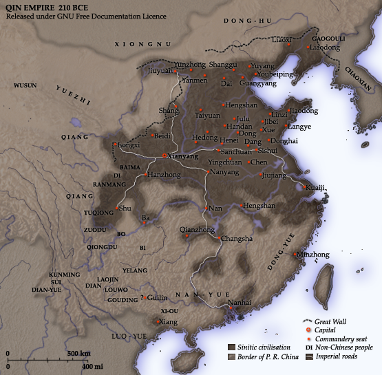
Fitxategi:Qin empire 210 BCE.png
Qin_empire_210_BCE.png ((555 × 545 pixel, fitxategiaren tamaina: 567 KB, MIME mota: image/png))
Fitxategiaren historia
Data/orduan klik egin fitxategiak orduan zuen itxura ikusteko.
| Data/Ordua | Iruditxoa | Neurriak | Erabiltzailea | Iruzkina | |
|---|---|---|---|---|---|
| oraingoa | 16:37, 10 abendua 2014 |  | 555 × 545 (567 KB) | Nguyen1310 | Update to include ''Luo-Yue'' (Vi: ''Lạc Việt'') a member of the Baiyue (100 Yue) peoples, on the map in northern Vietnam. |
| 16:08, 21 azaroa 2006 |  | 555 × 545 (540 KB) | Itsmine | == Commentary == As part of his unification of China in 221 BC, Qin Shi Huang divided his empire into thirty six commanderies, each subdivided into a number of counties. The significance of the administrative reforms was its in |
Irudira dakarten loturak
Hurrengo orrialdeek dute fitxategi honetarako lotura:
Fitxategiaren erabilera orokorra
Hurrengo beste wikiek fitxategi hau darabilte:
- af.wikipedia.org proiektuan duen erabilera
- ar.wikipedia.org proiektuan duen erabilera
- ast.wikipedia.org proiektuan duen erabilera
- bg.wikipedia.org proiektuan duen erabilera
- bo.wikipedia.org proiektuan duen erabilera
- br.wikipedia.org proiektuan duen erabilera
- bxr.wikipedia.org proiektuan duen erabilera
- ca.wikipedia.org proiektuan duen erabilera
- cdo.wikipedia.org proiektuan duen erabilera
- cs.wikipedia.org proiektuan duen erabilera
- cv.wikipedia.org proiektuan duen erabilera
- cy.wikipedia.org proiektuan duen erabilera
- da.wikipedia.org proiektuan duen erabilera
- de.wikipedia.org proiektuan duen erabilera
- en.wikipedia.org proiektuan duen erabilera
- es.wikipedia.org proiektuan duen erabilera
- fa.wikipedia.org proiektuan duen erabilera
- fr.wikipedia.org proiektuan duen erabilera
- ga.wikipedia.org proiektuan duen erabilera
- gl.wikipedia.org proiektuan duen erabilera
- hak.wikipedia.org proiektuan duen erabilera
- he.wikipedia.org proiektuan duen erabilera
- hi.wikipedia.org proiektuan duen erabilera
- hr.wikipedia.org proiektuan duen erabilera
- id.wikipedia.org proiektuan duen erabilera
- incubator.wikimedia.org proiektuan duen erabilera
- jv.wikipedia.org proiektuan duen erabilera
- ka.wikipedia.org proiektuan duen erabilera
Ikus fitxategi honen erabilpen global gehiago.


