Fitxategi:Population density.png

Aurreikuspen honen neurria: 800 × 400 pixel. Bestelako bereizmenak: 320 × 160 pixel | 640 × 320 pixel | 1.024 × 512 pixel | 1.280 × 640 pixel | 2.560 × 1.280 pixel | 4.320 × 2.160 pixel.
Bereizmen handikoa ((4.320 × 2.160 pixel, fitxategiaren tamaina: 522 KB, MIME mota: image/png))
Fitxategiaren historia
Data/orduan klik egin fitxategiak orduan zuen itxura ikusteko.
| Data/Ordua | Iruditxoa | Neurriak | Erabiltzailea | Iruzkina | |
|---|---|---|---|---|---|
| oraingoa | 02:41, 11 apirila 2013 |  | 4.320 × 2.160 (522 KB) | Jahoe | Re-downloaded original from http://eoimages.gsfc.nasa.gov/images/imagerecords/53000/53005/population_density.tif, re-converted to PNG (preserving alpha channel) using tiff2png (by Willem van Schaik and Greg Roelofs). Removed rgb pixel values from fully... |
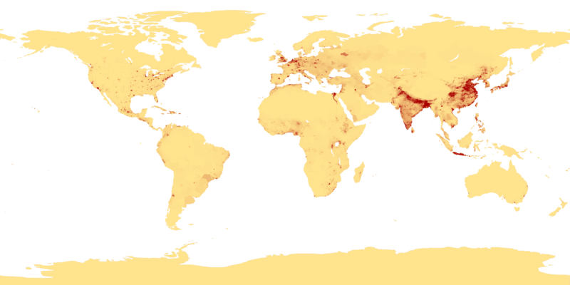
| 05:41, 27 otsaila 2007 |  | 4.320 × 2.160 (915 KB) | Keenan Pepper | This image shows the number of people per square kilometer around the world in 1994. The data were derived from population records based on political divisions such as states, provinces, and counties. The image was taken from [http://visibleearth.nasa.go |
Irudira dakarten loturak
Hurrengo orrialdeek dute fitxategi honetarako lotura:
Fitxategiaren erabilera orokorra
Hurrengo beste wikiek fitxategi hau darabilte:
- als.wikipedia.org proiektuan duen erabilera
- an.wikipedia.org proiektuan duen erabilera
- ar.wikipedia.org proiektuan duen erabilera
- ast.wikipedia.org proiektuan duen erabilera
- az.wikipedia.org proiektuan duen erabilera
- be-tarask.wikipedia.org proiektuan duen erabilera
- be.wikipedia.org proiektuan duen erabilera
- bg.wikipedia.org proiektuan duen erabilera
- bh.wikipedia.org proiektuan duen erabilera
- bn.wikipedia.org proiektuan duen erabilera
- bs.wikipedia.org proiektuan duen erabilera
- ca.wikipedia.org proiektuan duen erabilera
- ce.wikipedia.org proiektuan duen erabilera
- ckb.wikipedia.org proiektuan duen erabilera
- cu.wikipedia.org proiektuan duen erabilera
- cv.wikipedia.org proiektuan duen erabilera
- da.wikipedia.org proiektuan duen erabilera
- da.wikibooks.org proiektuan duen erabilera
- de.wikipedia.org proiektuan duen erabilera
- dsb.wikipedia.org proiektuan duen erabilera
- el.wikipedia.org proiektuan duen erabilera
- en.wikipedia.org proiektuan duen erabilera
- en.wikiquote.org proiektuan duen erabilera
- eo.wikipedia.org proiektuan duen erabilera
- es.wikipedia.org proiektuan duen erabilera
Ikus fitxategi honen erabilpen global gehiago.


