Fitxategi:Pollution over east China.jpg

Bereizmen handikoa ((6.000 × 4.600 pixel, fitxategiaren tamaina: 2,12 MB, MIME mota: image/jpeg))
Fitxategi hau Wikimedia Commonsekoa da. Hango deskribapen orriko informazioa behean duzu. |
Laburpena
| Deskribapena |
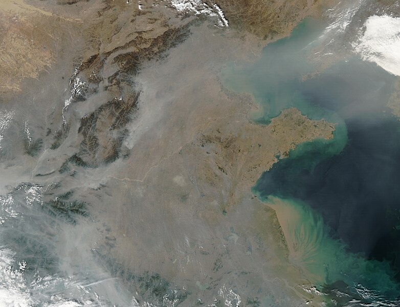
This true-color image over eastern China was acquired by the Moderate Resolution Imaging Spectroradiometer (MODIS), flying aboard NASA’s Aqua satellite, on Oct. 16, 2002 [1]. The scene reveals dozens of fires burning on the surface (red dots) and a thick pall of smoke and haze (greyish pixels) filling the skies overhead. Notice in the high-resolution version of this image how the smog fills the valleys and courses around the contours of the terrain in China’s hilly and mountainous regions. The terrain higher in elevation is less obscured by the smog than the lower lying plains and valleys in the surrounding countryside. This scene spans roughly from Beijing (near top center) to the Yangtze River, the mouth of which can be seen toward the bottom right. Toward the upper right corner, the Bo Hai Bay is rather obscured by the plume of pollution blowing eastward toward Korea and the Pacific Ocean. Toward the bottom right, the Yangtze River is depositing its brownish, sediment-laden waters into the Yellow Sea. |
| Jatorria | |
| Egilea |
Lizentzia
| This file is in the public domain in the United States because it was solely created by NASA. NASA copyright policy states that "NASA material is not protected by copyright unless noted". (See Template:PD-USGov, NASA copyright policy page or JPL Image Use Policy.) | ||
 |
Warnings:
|
Jatorrizko igoera erregistroa
- 2007-03-16 02:27 Kgrr 6000×4600×8 (2227952 bytes) This true-color image over eastern China was acquired by the Moderate Resolution Imaging Spectroradiometer (MODIS), flying aboard NASA’s Aqua satellite, on Oct. 16, 2002 [http://earthobservatory.nasa.gov/Newsroom/NewImages/images.php3?img_id=10795]. Th
Fitxategiaren historia
Data/orduan klik egin fitxategiak orduan zuen itxura ikusteko.
| Data/Ordua | Iruditxoa | Neurriak | Erabiltzailea | Iruzkina | |
|---|---|---|---|---|---|
| oraingoa | 12:52, 23 martxoa 2007 | | 6.000 × 4.600 (2,12 MB) | Liftarn | {{Information |Description=This true-color image over eastern China was acquired by the Moderate Resolution Imaging Spectroradiometer (MODIS), flying aboard NASA’s Aqua satellite, on Oct. 16, 2002 [http://earthobservatory.nasa.gov/Newsroom/NewImages/ima |
Irudira dakarten loturak
Hurrengo orrialdeek dute fitxategi honetarako lotura:
Fitxategiaren erabilera orokorra
Hurrengo beste wikiek fitxategi hau darabilte:
- ar.wikipedia.org proiektuan duen erabilera
- arz.wikipedia.org proiektuan duen erabilera
- ast.wikipedia.org proiektuan duen erabilera
- ca.wikipedia.org proiektuan duen erabilera
- cs.wikipedia.org proiektuan duen erabilera
- en.wikipedia.org proiektuan duen erabilera
- es.wikipedia.org proiektuan duen erabilera
- fa.wikipedia.org proiektuan duen erabilera
- fi.wikipedia.org proiektuan duen erabilera
- fr.wikipedia.org proiektuan duen erabilera
- fy.wikipedia.org proiektuan duen erabilera
- id.wikipedia.org proiektuan duen erabilera
- it.wikipedia.org proiektuan duen erabilera
- ml.wikipedia.org proiektuan duen erabilera
- nl.wikipedia.org proiektuan duen erabilera
- no.wikipedia.org proiektuan duen erabilera
- oc.wikipedia.org proiektuan duen erabilera
- pl.wikipedia.org proiektuan duen erabilera
- pt.wikipedia.org proiektuan duen erabilera
- si.wikipedia.org proiektuan duen erabilera
- sq.wikibooks.org proiektuan duen erabilera
- ta.wikipedia.org proiektuan duen erabilera
- zh.wikipedia.org proiektuan duen erabilera