Fitxategi:Piri reis world map 01.jpg

Bereizmen handikoa ((1.964 × 2.619 pixel, fitxategiaren tamaina: 7,08 MB, MIME mota: image/jpeg))
Fitxategi hau Wikimedia Commonsekoa da. Hango deskribapen orriko informazioa behean duzu. |
Laburpena
|
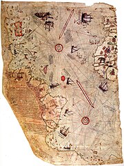
| Deskribapena |
العربية: خارطة العالم بِيد أمير البحار العُثماني حاجي أحمد مُحيي الدين پیري، الشهير باسم پيري ريِّس، رُسمت سنة 1513م. لم يبقَ اليوم سوى نصف الخارطة الأصليَّة، التي يُحتفظ بها في متحف سراي طوپ قاپي في إسطنبول. تجمع هذه الخارطة معلومات من حوالي عشرين خريطة أُخرى، بما فيها إحدى الخرائط التي وضعها كريستوفر كولومبوس بنفسه وخطط فيها سواحل العالم الجديد.
English: Map of the world by Ottoman admiral Piri Reis, drawn in 1513. Only part of the original map survives and is held at the Topkapi Museum in Istanbul. The map synthesizes information from many maps, including one drawn by Christopher Columbus of the Caribbean.
Türkçe: Osmanlı amirali Piri Reis tarafından 1513'te çizilmiş olan, Avrupa ve Afrika'nın batı kıyılarıyla Güney Amerika'nın doğu kıyılarını gösteren dünyanın en eski haritalarından biri olan Piri Reis'in ilk Dünya haritası. |
||||||||||||||||||||
| Data | |||||||||||||||||||||
| Jatorria | Library of Topkapi Palace Museum, No. H 1824 Bilkent University (lo res), erisi.com (hi res) | ||||||||||||||||||||
| Egilea |
|
||||||||||||||||||||

Lizentzia
|
Honoko hau, domeinu publikoan dagoen bi dimentsioko artelan baten argazki-erreprodukzio fidela da. Artelana domeinu publikoan dago ondoko arrazoi hauengatik:
Wikimedia Fundazioak duen jarrera ofiziala hau da:«domeinu publikoan dauden bi dimentsioko erreprodukzio fidelak domeinu publikokoak dira.»
Argazki-erreprodukzio hau, beraz, domeinu publikokotzat hartzen da Estatu Batuetan. Beste jurisdikzio batzuetan eduki honen berrerabilera mugatua egon liteke; xehetasunetarako, ikus Reuse of PD-Art photographs. | ||||
| Annotations | This image is annotated: View the annotations at Commons |
Fitxategiaren historia
Data/orduan klik egin fitxategiak orduan zuen itxura ikusteko.
| Data/Ordua | Iruditxoa | Neurriak | Erabiltzailea | Iruzkina | |
|---|---|---|---|---|---|
| oraingoa | 01:16, 18 uztaila 2017 | | 1.964 × 2.619 (7,08 MB) | Earthsound | Reverted to version as of 04:00, 17 August 2012 (UTC) The higher resolution images that replaced this are horribly pixelated and have been created by enlarging a much smaller copy. |
| 14:45, 13 azaroa 2016 |  | 3.387 × 4.807 (2,16 MB) | Alonso de Mendoza | color | |
| 15:19, 5 martxoa 2016 |  | 3.387 × 4.807 (1,6 MB) | ديفيد عادل وهبة خليل 2 | Cropped 5 % horizontally and 5 % vertically using CropTool with precise mode. | |
| 12:37, 23 azaroa 2014 |  | 3.564 × 5.040 (1.019 KB) | Ratzer | higher Resolution 3564 x 5040, source http://www.erisi.com/gelisim/harita/pri/piri_dunya.jpg | |
| 06:00, 17 abuztua 2012 |  | 1.964 × 2.619 (7,08 MB) | FunkMonk | ||
| 04:45, 10 otsaila 2008 |  | 2.000 × 2.753 (2,27 MB) | FunkMonk | {{Information |Description= |Source= |Date= |Author= |Permission= |other_versions= }} | |
| 16:45, 13 iraila 2006 |  | 829 × 1.087 (205 KB) | InfoCan | rotated previous version of map so North is up. | |
| 09:09, 29 iraila 2005 |  | 1.087 × 829 (338 KB) | CristianChirita | Piri Reis World Map |
Irudira dakarten loturak
Hurrengo orrialdeek dute fitxategi honetarako lotura:
Fitxategiaren erabilera orokorra
Hurrengo beste wikiek fitxategi hau darabilte:
- ar.wikipedia.org proiektuan duen erabilera
- جزر الأنتيل
- بوابة:الدولة العثمانية/صورة
- ويكيبيديا:صور مختارة/رسومات وجداول وخرائط/خرائط
- بيري ريس
- خريطة بيري ريس
- ويكيبيديا:ترشيحات الصور المختارة/خريطة أحمد محيي الدين امريكا
- ويكيبيديا:صورة اليوم المختارة/مايو 2016
- قالب:صورة اليوم المختارة/2016-05-23
- بوابة:الدولة العثمانية/صورة مختارة/19
- ويكيبيديا:صورة اليوم المختارة/أغسطس 2017
- قالب:صورة اليوم المختارة/2017-08-22
- ويكيبيديا:صورة اليوم المختارة/يوليو 2019
- قالب:صورة اليوم المختارة/2019-07-23
- كتاب الملاحة
- ويكيبيديا:صورة اليوم المختارة/يناير 2022
- قالب:صورة اليوم المختارة/2022-01-15
- azb.wikipedia.org proiektuan duen erabilera
- az.wikipedia.org proiektuan duen erabilera
- bg.wikipedia.org proiektuan duen erabilera
- bn.wikipedia.org proiektuan duen erabilera
- ca.wikipedia.org proiektuan duen erabilera
- cbk-zam.wikipedia.org proiektuan duen erabilera
- ckb.wikipedia.org proiektuan duen erabilera
- cs.wikipedia.org proiektuan duen erabilera
- da.wikipedia.org proiektuan duen erabilera
- de.wikipedia.org proiektuan duen erabilera
- 1513
- Piri Reis
- Karte des Piri Reis
- Antillen
- Entwicklungsgeschichte der Seekarte
- Portal Diskussion:Türkei/Bild der Woche/Kandidaten/Archiv/2008
- Benutzer:DasAugeDerWahrheit
- Portal Diskussion:Türkei/Archiv/2009
- Portal:Türkei/Bild/Archiv
- Charles Hapgood
- Liste historischer Weltkarten
- Theorie der muslimischen Entdeckung Amerikas
- en.wikipedia.org proiektuan duen erabilera
Ikus fitxategi honen erabilpen global gehiago.