Fitxategi:Palestine Map 2007.gif
Bereizmen handikoa ((780 × 970 pixel, fitxategiaren tamaina: 103 KB, MIME mota: image/gif))
Fitxategi hau Wikimedia Commonsekoa da. Hango deskribapen orriko informazioa behean duzu. |
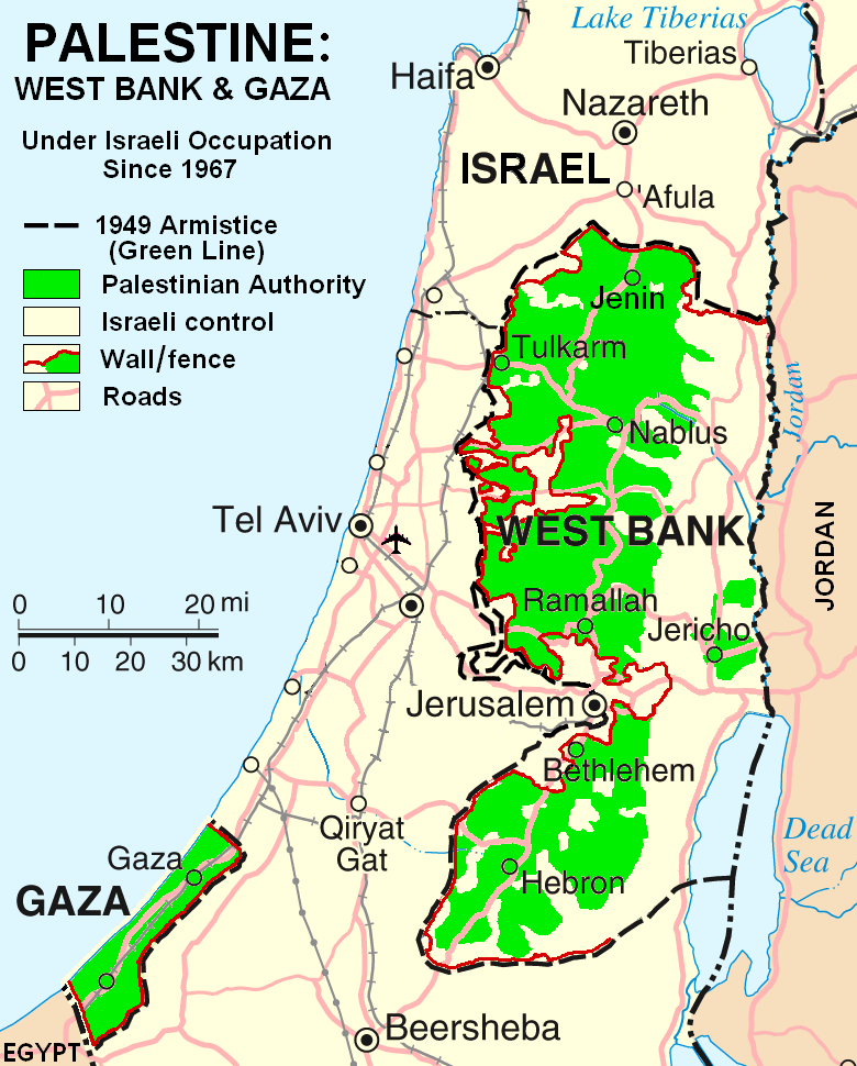
Laburpena
This map is a modification, suggested as a replacement for the one uploaded by ChrisO at
which is used in the Wikipedia article "Palestine," under the History subheading Current Status.
My modification shows "facts on the ground" which are essential to any understanding of the situation in Palestine today. The geographic facts are not in dispute. They have been widely published in print and on the internet.
Both my map and the ChrisO map are modifications of a 2004 United Nations map of Israel:
(public domain) in which the three Occupied Territories, the West Bank, Gaza, and Golan, are given the same brown color as Israel's neighboring countries: Egypt, Jordan, Syria, and Lebanon. ChrisO colors the West Bank, Gaza, and Golan light green and renames the map "Israel and the Occupied Territories." However Golan is Syrian, not Palestinian. For an article on Palestine, attention should be on the West Bank and Gaza.
My modification crops out Golan and the Negev desert to focus in on the West Bank and Gaza. It also incorporates information from several published sources to show the land and resources actually available to Palestinian people in these two territories, the West Bank in particular.
The main source of information on barriers and land distribution comes from a map by the United Nations Office for the Coordination of Humanitarian Affairs:
supplemented by two more United Nations maps:
- http://www.ochaopt.org/documents/WB_Barrier_Projections_July06.pdf archive copy at the Wayback Machine
- http://www.ochaopt.org/documents/WB_Closure_Access_revised_CAP_June06.pdf archive copy at the Wayback Machine
Two Israeli organizations have published similar maps:
- http://www.btselem.org/Download/Separation_Barrier_Map_Eng.pdf
- http://www.icahd.org/eng/images/articles/the-matrix-of-control.gif archive copy at the Wayback Machine
And finally, the Washington Post published all this information on a full-page newspaper map:
Each of these maps is much too detailed to illustrate a Wikipedia article. My modification simplifies the information for use on a map similar in scale to the other maps in the article on Palestine.
Similar maps with locations of Israeli settlements are posted at:
.gif)
.gif&action=edit&redlink=1)
Lizentzia
| Nik, lan honen egile eskubideen jabeak, lan hau domeinu publikoan jartzen dut. Mundu osoan du eragina honek. Estatu batzuetan beharbada hori ez da legez posible izango. Halakoetan: Edonori ematen diot lan hau edozertarako erabiltzeko eskubidea, inolako baldintzarik gabe, legeak nahitaez ezarritako baldintzak izan ezik. |
Fitxategiaren historia
Data/orduan klik egin fitxategiak orduan zuen itxura ikusteko.
| Data/Ordua | Iruditxoa | Neurriak | Erabiltzailea | Iruzkina | |
|---|---|---|---|---|---|
| oraingoa | 18:03, 11 apirila 2007 | | 780 × 970 (103 KB) | HowardMorland | |
| 23:37, 6 apirila 2007 |  | 780 × 970 (101 KB) | HowardMorland | This map is a modification, suggested as a replacement for the one uploaded by ChrisO at http://en.wikipedia.org/wiki/Image:Israel_and_occupied_territories_map.png which is used in the Wikipedia article "Palestine," under the History subheading Curre | |
| 12:41, 5 apirila 2007 |  | 780 × 970 (101 KB) | HowardMorland | This map is a modification, suggested as a replacement for the one uploaded by ChrisO at http://en.wikipedia.org/wiki/Image:Israel_and_occupied_territories_map.png which is used in the Wikipedia article "Palestine," under the History subheading Curre | |
| 01:49, 5 apirila 2007 |  | 780 × 970 (101 KB) | HowardMorland | This map is a modification, intended to replace the one uploaded by ChrisO at http://en.wikipedia.org/wiki/Image:Israel_and_occupied_territories_map.png which is used in the Wikipedia article "Palestine" under the subheading "Current Status." My mod |
Irudira dakarten loturak
Hurrengo orrialdeek dute fitxategi honetarako lotura:
Fitxategiaren erabilera orokorra
Hurrengo beste wikiek fitxategi hau darabilte:
- de.wiktionary.org proiektuan duen erabilera
- en.wikipedia.org proiektuan duen erabilera