Fitxategi:Oxfordshire UK locator map 2010.svg

SVG fitxategi honen PNG aurreikuspenaren tamaina: 494 × 600 pixel. Bestelako bereizmenak: 198 × 240 pixel | 395 × 480 pixel | 633 × 768 pixel | 843 × 1.024 pixel | 1.687 × 2.048 pixel | 1.108 × 1.345 pixel.
Bereizmen handikoa (SVG fitxategia, nominaldi 1.108 × 1.345 pixel, fitxategiaren tamaina: 302 KB)
Fitxategi hau Wikimedia Commonsekoa da. Hango deskribapen orriko informazioa behean duzu. |
Laburpena
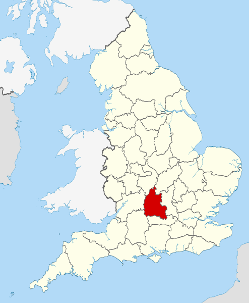
| Deskribapena | Location of the ceremonial county of Oxfordshire within England. |
| Data | |
| Jatorria |
National Geospatial-Intelligence Agency
|
| Egilea | Nilfanion |
Lizentzia
Nik, lan honen egileak, argitaratzen dut ondorengo lizentzia hauen pean:
Fitxategi hau Creative Commons Attribution-Share Alike 3.0 Unported lizentziapean dago.
- Askea zara:
- partekatzeko – lana kopiatzeko, banatzeko eta bidaltzeko
- birnahasteko – lana moldatzeko
- Ondorengo baldintzen pean:
- eskuduntza – Egiletza behar bezala aitortu behar duzu, lizentzia ikusteko esteka gehitu, eta ea aldaketak egin diren aipatu. Era egokian egin behar duzu hori guztia, baina inola ere ez egileak zure lana edo zure erabilera babesten duela irudikatuz.
- berdin partekatu – Lan honetan oinarrituta edo aldatuta berria eraikitzen baduzu, emaitza lana hau bezalako lizentzia batekin argitaratu behar duzu.

|
Baimena duzu dokumentu hau kopiatu, banatu edo/eta aldatzeko GNU Free Documentation License baldintzapean, Free Software Foundationek argitaratutako 1.2 edo ondorengo bertsioan; sekzio aldaezinik gabe, azaleko testurik gabe, eta atzeko azaleko testurik gabe. Lizentziaren kopia dago GNU Free Documentation License izenburudun atalean. |
Nahiago duzun lizentzia erabil dezakezu.

|
This is one of the images forming part of the Valued image set: Locator maps of the Ceremonial counties of England on Wikimedia Commons. The image set has been assessed under the valued image set criteria and is considered the most valued set on Commons within the scope:
Locator maps of the Ceremonial counties of England
You can see its nomination at Commons:Valued image candidates/Locator maps of English ceremonial counties. |
Fitxategiaren historia
Data/orduan klik egin fitxategiak orduan zuen itxura ikusteko.
| Data/Ordua | Iruditxoa | Neurriak | Erabiltzailea | Iruzkina | |
|---|---|---|---|---|---|
| oraingoa | 00:25, 24 azaroa 2010 | | 1.108 × 1.345 (302 KB) | Nilfanion | use ceremonial counties - corresponds with text of article better |
| 18:39, 23 azaroa 2010 |  | 1.108 × 1.345 (332 KB) | Nilfanion | Fix coast - add Arran | |
| 02:47, 16 azaroa 2010 |  | 1.108 × 1.345 (325 KB) | Nilfanion | thicker lines | |
| 02:44, 16 azaroa 2010 |  | 1.108 × 1.345 (325 KB) | Nilfanion | {{Information |Description=Location of Oxfordshire within England, with the administrative counties shown. |Source=Ordnance Survey [https://www.ordnancesurvey.co.uk/opendatadownload/products.html OpenData]: *County |
Irudira dakarten loturak
Ez dago fitxategi hau darabilen orririk.
Fitxategiaren erabilera orokorra
Hurrengo beste wikiek fitxategi hau darabilte:
- af.wikipedia.org proiektuan duen erabilera
- an.wikipedia.org proiektuan duen erabilera
- ar.wikipedia.org proiektuan duen erabilera
- arz.wikipedia.org proiektuan duen erabilera
- ast.wikipedia.org proiektuan duen erabilera
- be-tarask.wikipedia.org proiektuan duen erabilera
- bg.wikipedia.org proiektuan duen erabilera
- bn.wikipedia.org proiektuan duen erabilera
- br.wikipedia.org proiektuan duen erabilera
- ca.wikipedia.org proiektuan duen erabilera
- ceb.wikipedia.org proiektuan duen erabilera
- cs.wikipedia.org proiektuan duen erabilera
- en.wikipedia.org proiektuan duen erabilera
- Oxfordshire
- Dragon Hill, Uffington
- RAF Bampton Castle
- Whitchurch-on-Thames
- Cowley Road, Oxford
- Redgrave Pinsent Rowing Lake
- Roke
- Farmoor Reservoir
- Mill Meadows, Henley-on-Thames
- River Evenlode
- Radford, Oxfordshire
- Angel & Greyhound Meadow, Oxford
- Curbridge, Oxfordshire
- Risinghurst and Sandhills
- Barford St. John and St. Michael
- Template:Oxfordshire-geo-stub
- Ardington
- Aston, Cote, Shifford and Chimney
- Aston Upthorpe
- Beckley and Stowood
- Bix and Assendon
- Blenheim, Oxfordshire
- Peckwater Quadrangle
- Bourton, Cherwell
- Bruern
- Ploughley Rural District
- Hanney
- Waterperry
- Dunsden Green
- Milton-under-Wychwood
- North Newington
- The Trout Inn
- Badbury Hill
- Oxford MSA
Ikus fitxategi honen erabilpen global gehiago.