Fitxategi:Okterritory.png

Aurreikuspen honen neurria: 800 × 477 pixel. Bestelako bereizmenak: 320 × 191 pixel | 640 × 382 pixel | 1.024 × 611 pixel | 1.280 × 763 pixel | 2.515 × 1.500 pixel.
Bereizmen handikoa ((2.515 × 1.500 pixel, fitxategiaren tamaina: 534 KB, MIME mota: image/png))
Fitxategi hau Wikimedia Commonsekoa da. Hango deskribapen orriko informazioa behean duzu. |

|
Irudi hau birsortu beharko litzateke SVG irudi bektorial moduan. Honek abantaila asko ematen ditu, ikus Commons:Media for cleanup (ingelesez) informazio gehiagorako. Irudi honen SVG bertsioa eskuragarri badago, mesedez Commonsera igo. Igo ostean, ordezkatu txantiloi hau txantiloi honegatik {{vector version available|irudiaren izen berria.svg}} irudi honetan.
|
Laburpena
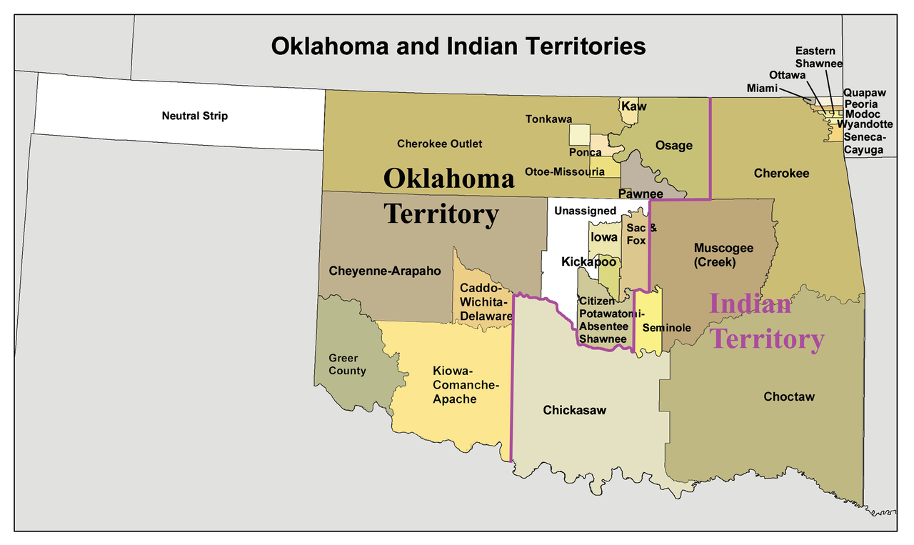
English: A map of the Oklahoma Territory and the reduced Indian Territory circa 1890's.
- In present day Oklahoma.
- Credits
- I made this using Census Bureau data and this 1892 map as a reference.
Lizentzia
Nik, lan honen egileak, argitaratzen dut ondorengo lizentzia pean:
Fitxategi hau Creative Commons Attribution-Share Alike 3.0 Unported lizentziapean dago.
- Askea zara:
- partekatzeko – lana kopiatzeko, banatzeko eta bidaltzeko
- birnahasteko – lana moldatzeko
- Ondorengo baldintzen pean:
- eskuduntza – Egiletza behar bezala aitortu behar duzu, lizentzia ikusteko esteka gehitu, eta ea aldaketak egin diren aipatu. Era egokian egin behar duzu hori guztia, baina inola ere ez egileak zure lana edo zure erabilera babesten duela irudikatuz.
- berdin partekatu – Lan honetan oinarrituta edo aldatuta berria eraikitzen baduzu, emaitza lana hau bezalako lizentzia batekin argitaratu behar duzu.
Fitxategiaren historia
Data/orduan klik egin fitxategiak orduan zuen itxura ikusteko.
| Data/Ordua | Iruditxoa | Neurriak | Erabiltzailea | Iruzkina | |
|---|---|---|---|---|---|
| oraingoa | 18:34, 20 urtarrila 2010 | | 2.515 × 1.500 (534 KB) | Kmusser | spelling correction |
| 17:10, 20 urtarrila 2010 |  | 2.551 × 1.500 (557 KB) | Kmusser | increased resolution | |
| 20:02, 31 uztaila 2006 |  | 600 × 358 (33 KB) | Kmusser | == Summary == This is a map of Oklahoma and Indian Territory circa 1890's that I made using and Census Bureau data and [http://hdl.loc.gov/loc.gmd/g4021e.ct000224 this |
Irudira dakarten loturak
Hurrengo orrialdeek dute fitxategi honetarako lotura:
Fitxategiaren erabilera orokorra
Hurrengo beste wikiek fitxategi hau darabilte:
- af.wikipedia.org proiektuan duen erabilera
- ar.wikipedia.org proiektuan duen erabilera
- arz.wikipedia.org proiektuan duen erabilera
- bcl.wikipedia.org proiektuan duen erabilera
- bn.wikipedia.org proiektuan duen erabilera
- ca.wikipedia.org proiektuan duen erabilera
- Osages
- Chickasaw (grup humà)
- Choctaws
- Wichita (poble)
- Tonkawes
- Caddos
- Comtat de Cimarron
- Comtat de Beaver (Oklahoma)
- Oklahoma Panhandle
- Cinc tribus civilitzades
- Apatxe kiowa
- Territori Indi
- Nació Chickasaw
- Plantilla:Territori Indi
- Nació Choctaw d'Oklahoma
- Districte Apukshunnubbee
- Districte Moshulatubbee
- Districte Pushmataha
- Nació Muscogee
- Estat de Sequoyah
- Nació Seminola d'Oklahoma
- Indian Intercourse Act
- Llei Orgànica d'Oklahoma
- chr.wikipedia.org proiektuan duen erabilera
- chy.wikipedia.org proiektuan duen erabilera
- cy.wikipedia.org proiektuan duen erabilera
- de.wikipedia.org proiektuan duen erabilera
Ikus fitxategi honen erabilpen global gehiago.