Fitxategi:National Atlas Louisiana east detailed.gif
Ez dago bereizmen handiagorik.
National_Atlas_Louisiana_east_detailed.gif ((490 × 600 pixel, fitxategiaren tamaina: 70 KB, MIME mota: image/gif))
Fitxategi hau Wikimedia Commonsekoa da. Hango deskribapen orriko informazioa behean duzu. |
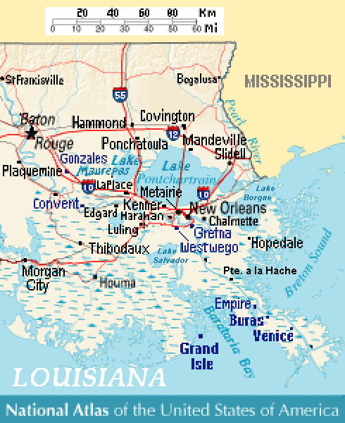
| Deskribapena |
Close view of east-southeast Louisiana (USA), showing areas of Baton Rouge, New Orleans, Metairie, Chalmette, Gretna, Westwego, Harahan, Luling, Kenner, LaPlace, Edgard, Convent, Slidell, Mandeville, Covington, Ponchatoula, Empire, Buras, Venice, and Grand Isle, Louisiana. Lakes include: Lake Pontchartrain, Lake Maurepas (west), and Lake Salvador (south). |
| Data | |
| Jatorria | Except from National Atlas of the United States, with more towns labeled/clarified. |
| Egilea | MyName (Wikid77) |
| Beste bertsioak | (none yet) |
References
- Louisiana-Map.org, webpage: LaMap-Louisiana-road-map (shows town/lake names).
This map was obtained from an edition of the National Atlas of the United States. Like almost all works of the U.S. federal government, works from the National Atlas are in the public domain in the United States.
Online access: NationalAtlas.gov | 1970 print edition: Library of Congress, Perry-Castañeda Library
|
Fitxategiaren historia
Data/orduan klik egin fitxategiak orduan zuen itxura ikusteko.
| Data/Ordua | Iruditxoa | Neurriak | Erabiltzailea | Iruzkina | |
|---|---|---|---|---|---|
| oraingoa | 16:08, 9 uztaila 2007 | | 490 × 600 (70 KB) | Wikid77 | added labels "en:Lake Borgne" & "Lake Salvador" + "Pte. a la Hache" |
| 15:45, 9 uztaila 2007 |  | 490 × 600 (69 KB) | Wikid77 | curved "LOUISIANA"; clarified "Lake"; spelling "Barataria Bay" was "Barararia" | |
| 14:05, 9 uztaila 2007 |  | 490 × 600 (69 KB) | Wikid77 | {{Information | Description= Close view of east-southeast Louisiana (USA), showing areas of Baton Rouge, New Orleans, Metairie, Chalmette, Gretna, Westwego, [[:en: |
Irudira dakarten loturak
Hurrengo orrialdeek dute fitxategi honetarako lotura:
Fitxategiaren erabilera orokorra
Hurrengo beste wikiek fitxategi hau darabilte:
- en.wikipedia.org proiektuan duen erabilera
- fr.wikipedia.org proiektuan duen erabilera
- pt.wikipedia.org proiektuan duen erabilera
- ru.wikipedia.org proiektuan duen erabilera