Fitxategi:Naddniestrze.png
Bereizmen handikoa ((2.655 × 3.786 pixel, fitxategiaren tamaina: 5,13 MB, MIME mota: image/png))
Fitxategi hau Wikimedia Commonsekoa da. Hango deskribapen orriko informazioa behean duzu. |
Laburpena
| Deskribapena |
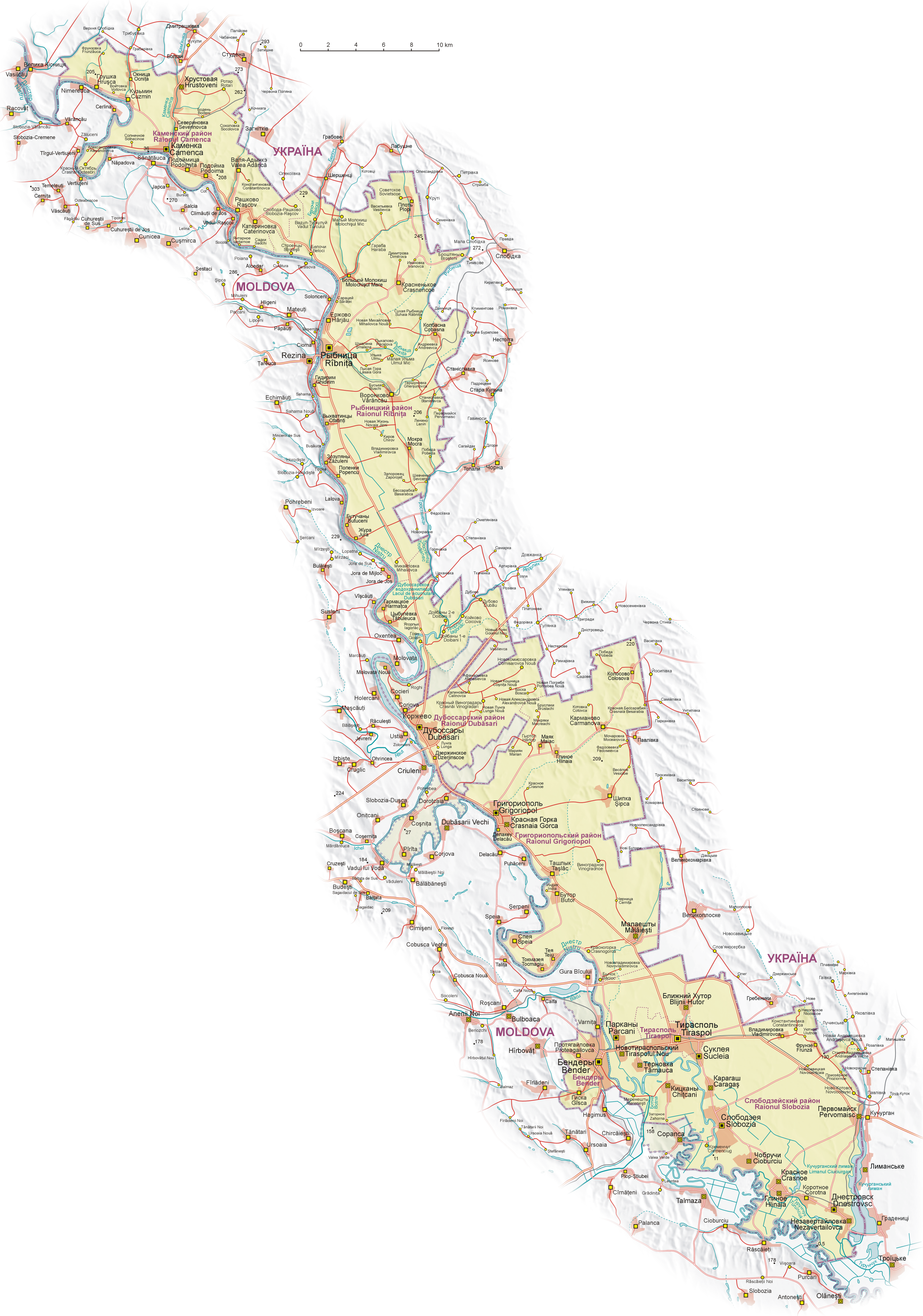
English: Map of Transnistria (with claimed area), based on Soviet and Ukrainian topographic map, and Shuttle Radar Topography Mission (STRM).
Geographical names:
 Polski: Mapa Naddniestrza (wraz z obszarem roszczeń). Mapa opracowana na podstawie radzieckich map topograficznych w skali 1:100 000 z końca lat 80. oraz ukraińskich map topograficznych z lat 2002-2006, rzeźba terenu wygenerowana na podstawie danych Shuttle Radar Topography Mission (STRM) udostępnionych przez United States Geological Survey.
Nazewnictwo geograficzne:
 Español: Mapa de Transnistria, basado en mapas topográficos soviéticos y ucranianos, y en la STRM. Nombres geográficos:
|
| Data | |
| Jatorria | Norberak egina |
| Egilea | Aotearoa |
| Beste bertsioak |
|


.png)


Lizentzia

|
Baimena duzu dokumentu hau kopiatu, banatu edo/eta aldatzeko GNU Free Documentation License baldintzapean, Free Software Foundationek argitaratutako 1.2 edo ondorengo bertsioan; sekzio aldaezinik gabe, azaleko testurik gabe, eta atzeko azaleko testurik gabe. Lizentziaren kopia dago GNU Free Documentation License izenburudun atalean. |
| Fitxategi hau Creative Commons Attribution-Share Alike 3.0 Unported lizentziapean dago. | ||
| ||
| This licensing tag was added to this file as part of the GFDL licensing update. |
|
Irudi hau Kalitate irudien gidalerroen arabera baloratua izan da, eta ondorioz, Kalitatezko irudi izendatua izan da.
|
Fitxategiaren historia
Data/orduan klik egin fitxategiak orduan zuen itxura ikusteko.
| Data/Ordua | Iruditxoa | Neurriak | Erabiltzailea | Iruzkina | |
|---|---|---|---|---|---|
| oraingoa | 07:08, 27 uztaila 2011 | | 2.655 × 3.786 (5,13 MB) | Nicolay Sidorov | + русское название села Коржево, исправил название села Zahorna - Загорное, а не "Захорна" |
| 12:18, 14 iraila 2008 |  | 2.655 × 3.786 (5,21 MB) | Aotearoa | {{Information |Description= |Source= |Date= |Author= |Permission= |other_versions= }} | |
| 22:01, 25 abuztua 2008 |  | 2.655 × 3.790 (5,62 MB) | Aotearoa | {{Information |Description= |Source= |Date= |Author= |Permission= |other_versions= }} | |
| 21:39, 25 abuztua 2008 |  | 2.962 × 4.230 (6,21 MB) | Aotearoa | {{Information |Description= |Source= |Date= |Author= |Permission= |other_versions= }} | |
| 21:27, 25 abuztua 2008 |  | 3.054 × 4.271 (6,22 MB) | Aotearoa | {{Information |Description= |Source= |Date= |Author= |Permission= |other_versions= }} | |
| 20:51, 25 abuztua 2008 |  | 3.054 × 4.271 (6,22 MB) | Aotearoa | {{Information |Description={{en|1=Map of Transnistria, based on Soviet and Ucrainian topographic map, and Shuttle Radar Topography Mission (STRM). Names in Transnistria according Transnistrian government}} {{pl|1= |
Irudira dakarten loturak
Hurrengo orrialdeek dute fitxategi honetarako lotura:
Fitxategiaren erabilera orokorra
Hurrengo beste wikiek fitxategi hau darabilte:
- ast.wikipedia.org proiektuan duen erabilera
- ca.wikipedia.org proiektuan duen erabilera
- cs.wikipedia.org proiektuan duen erabilera
- de.wikipedia.org proiektuan duen erabilera
- en.wikipedia.org proiektuan duen erabilera
- eo.wikipedia.org proiektuan duen erabilera
- fr.wikipedia.org proiektuan duen erabilera
- fr.wikinews.org proiektuan duen erabilera
- gl.wikipedia.org proiektuan duen erabilera
- he.wikipedia.org proiektuan duen erabilera
- hu.wikipedia.org proiektuan duen erabilera
- is.wikipedia.org proiektuan duen erabilera
- ja.wikipedia.org proiektuan duen erabilera
- li.wikipedia.org proiektuan duen erabilera
- ml.wikipedia.org proiektuan duen erabilera
- nl.wikipedia.org proiektuan duen erabilera
- pa.wikipedia.org proiektuan duen erabilera
- pl.wikipedia.org proiektuan duen erabilera
- Wikipedysta:Aotearoa/brudnopis
- Wikipedia:Ilustracje na Medal/rysunki i animacje
- Wikipedia:Propozycje do Ilustracji na Medal/Naddniestrze.png
- Dyskusja pliku:Naddniestrze.png
- Wikipedysta:Aotearoa/mapy
- Szablon:Ilustracja na medal/2011-09-02
- Szablon:Ilustracja na medal/2012-02-14
- Szablon:Ilustracja na medal/2013-02-10
- Szablon:Ilustracja na medal/2014-08-16
- Wikipedysta:The Polish/Nieużywane szablony/Ilustracja na medal/1-500
- Wikipedysta:The Polish/Nieużywane szablony/Ilustracja na medal/501-1000
- Wikipedysta:The Polish/Nieużywane szablony/Ilustracja na medal/1001-1500
- pt.wikipedia.org proiektuan duen erabilera
- ro.wikipedia.org proiektuan duen erabilera
- ru.wikipedia.org proiektuan duen erabilera
- sd.wikipedia.org proiektuan duen erabilera
- sr.wikipedia.org proiektuan duen erabilera
- su.wikipedia.org proiektuan duen erabilera
Ikus fitxategi honen erabilpen global gehiago.