Fitxategi:NORTH SIDE AND WEST FRONT - St. Matrona Russian Orthodox Church, Port Heiden, Lake and Peninsula Borough, AK HABS AK,5-POHEI,1B-1.tif

TIF fitxategi honen JPG aurreikuspenaren tamaina: 800 × 579 pixel. Bestelako bereizmenak: 320 × 232 pixel | 640 × 463 pixel | 1.024 × 741 pixel | 1.280 × 927 pixel | 2.560 × 1.853 pixel | 5.000 × 3.620 pixel.
Bereizmen handikoa ((5.000 × 3.620 pixel, fitxategiaren tamaina: 17,26 MB, MIME mota: image/tiff))
Fitxategi hau Wikimedia Commonsekoa da. Hango deskribapen orriko informazioa behean duzu. |
Laburpena
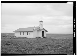
| NORTH SIDE AND WEST FRONT - St. Matrona Russian Orthodox Church, Port Heiden, Lake and Peninsula Borough, AK | ||||
|---|---|---|---|---|
| Argazkilari |
Lowe , Jet, creator |
|||
| Izenburua |
NORTH SIDE AND WEST FRONT - St. Matrona Russian Orthodox Church, Port Heiden, Lake and Peninsula Borough, AK |
|||
| Depicted place | Alaska; Lake & Peninsula Borough; Port Heiden | |||
| Data | 1990 | |||
| Teknika | 5 x 7 in. | |||
| Egungo kokapena |
Library of Congress Prints and Photographs Division Washington, D.C. 20540 USA http://hdl.loc.gov/loc.pnp/pp.print |
|||
| Erregistro-zenbakia |
HABS AK,5-POHEI,1B-1 |
|||
| Nondik eskuratua |
|
|||
| Jatorria | https://www.loc.gov/pictures/item/ak0431.photos.033271p | |||
| Lizentzia (Fitxategi hau berrerabiltzen) |
|
|||

| Kameraren kokapena | | Irudi hau eta gehiago beraien kokapenekin hurrengo lekuetan: OpenStreetMap |
|---|
Fitxategiaren historia
Data/orduan klik egin fitxategiak orduan zuen itxura ikusteko.
| Data/Ordua | Iruditxoa | Neurriak | Erabiltzailea | Iruzkina | |
|---|---|---|---|---|---|
| oraingoa | 23:45, 25 ekaina 2014 |  | 5.000 × 3.620 (17,26 MB) | Fæ | GWToolset: Creating mediafile for Fæ. HABS batch upload start 25 June 2014 |
Irudira dakarten loturak
Hurrengo orrialdeek dute fitxategi honetarako lotura:
Fitxategiaren erabilera orokorra
Hurrengo beste wikiek fitxategi hau darabilte:
- ar.wikipedia.org proiektuan duen erabilera
- arz.wikipedia.org proiektuan duen erabilera
- azb.wikipedia.org proiektuan duen erabilera
- ca.wikipedia.org proiektuan duen erabilera
- ceb.wikipedia.org proiektuan duen erabilera
- ce.wikipedia.org proiektuan duen erabilera
- en.wikipedia.org proiektuan duen erabilera
- es.wikipedia.org proiektuan duen erabilera
- fr.wikipedia.org proiektuan duen erabilera
- ht.wikipedia.org proiektuan duen erabilera
- it.wikipedia.org proiektuan duen erabilera
- lld.wikipedia.org proiektuan duen erabilera
- ml.wikipedia.org proiektuan duen erabilera
- no.wikipedia.org proiektuan duen erabilera
- pl.wikipedia.org proiektuan duen erabilera
- pt.wikipedia.org proiektuan duen erabilera
- ru.wikipedia.org proiektuan duen erabilera
- sr.wikipedia.org proiektuan duen erabilera
- tt.wikipedia.org proiektuan duen erabilera
- uk.wikipedia.org proiektuan duen erabilera
- uz.wikipedia.org proiektuan duen erabilera
- www.wikidata.org proiektuan duen erabilera