Fitxategi:Map of Ohio NA.png

Aurreikuspen honen neurria: 800 × 542 pixel. Bestelako bereizmenak: 320 × 217 pixel | 640 × 434 pixel | 1.024 × 694 pixel | 1.280 × 867 pixel | 1.967 × 1.333 pixel.
Bereizmen handikoa ((1.967 × 1.333 pixel, fitxategiaren tamaina: 2,02 MB, MIME mota: image/png))
Fitxategi hau Wikimedia Commonsekoa da. Hango deskribapen orriko informazioa behean duzu. |
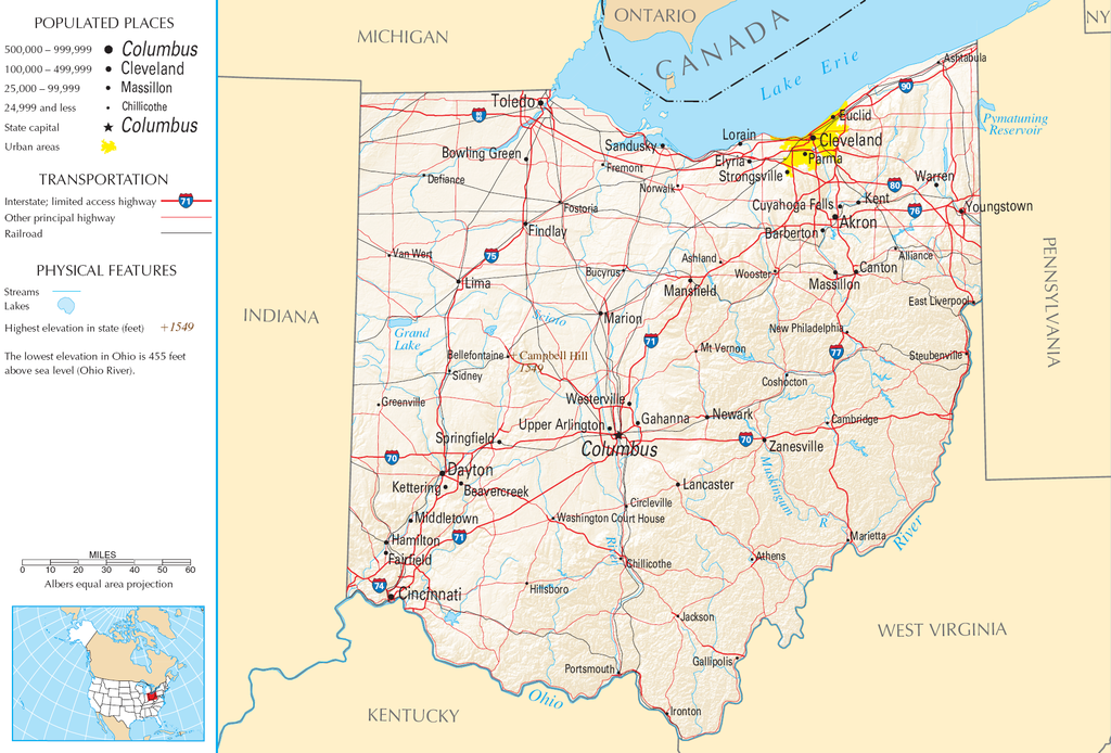
| Deskribapena | Map of Ohio |
| Jatorria | National Atlas |
| Egilea |
This map was obtained from an edition of the National Atlas of the United States. Like almost all works of the U.S. federal government, works from the National Atlas are in the public domain in the United States.
Online access: NationalAtlas.gov | 1970 print edition: Library of Congress, Perry-Castañeda Library
|
Fitxategiaren historia
Data/orduan klik egin fitxategiak orduan zuen itxura ikusteko.
| Data/Ordua | Iruditxoa | Neurriak | Erabiltzailea | Iruzkina | |
|---|---|---|---|---|---|
| oraingoa | 13:21, 30 abuztua 2007 | | 1.967 × 1.333 (2,02 MB) | Conscious | cropped |
| 10:02, 15 abuztua 2006 |  | 2.122 × 1.640 (2,17 MB) | Huebi~commonswiki | {{Information| |Description=Map of Ohio |Source=[http://www.nationalatlas.gov National Atlas] }} Category:Maps of the United States Category:Maps of Ohio {{PD-USGov-Atlas}} |
Irudira dakarten loturak
Hurrengo orrialdeek dute fitxategi honetarako lotura:
Fitxategiaren erabilera orokorra
Hurrengo beste wikiek fitxategi hau darabilte:
- arz.wikipedia.org proiektuan duen erabilera
- de.wikipedia.org proiektuan duen erabilera
- en.wikipedia.org proiektuan duen erabilera
- es.wikipedia.org proiektuan duen erabilera
- fr.wikipedia.org proiektuan duen erabilera
- gl.wikipedia.org proiektuan duen erabilera
- hr.wiktionary.org proiektuan duen erabilera
- hsb.wikipedia.org proiektuan duen erabilera
- hu.wikipedia.org proiektuan duen erabilera
- incubator.wikimedia.org proiektuan duen erabilera
- io.wikipedia.org proiektuan duen erabilera
- it.wikipedia.org proiektuan duen erabilera
- ja.wikipedia.org proiektuan duen erabilera
- kk.wikipedia.org proiektuan duen erabilera
- mk.wikipedia.org proiektuan duen erabilera
- mr.wikipedia.org proiektuan duen erabilera
- nl.wikipedia.org proiektuan duen erabilera
- rue.wikipedia.org proiektuan duen erabilera
- ru.wikipedia.org proiektuan duen erabilera
- stq.wikipedia.org proiektuan duen erabilera
- sw.wikipedia.org proiektuan duen erabilera
- szl.wikipedia.org proiektuan duen erabilera
- zea.wikipedia.org proiektuan duen erabilera