Fitxategi:Map Canada political-geo.png

Bereizmen handikoa ((1.280 × 1.128 pixel, fitxategiaren tamaina: 492 KB, MIME mota: image/png))
Fitxategi hau Wikimedia Commonsekoa da. Hango deskribapen orriko informazioa behean duzu. |
Laburpena
| Deskribapena |
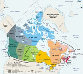
Map: Canada – geopolitical Drawn and adapted by E Pluribus Anthony from Atlas of Canada Edited by en:User:Heqs/en:User:Cogito ergo sumo to show disputed nature of Canada's marine international boundary claims; see en:Canada-United_States_border#Remaining_boundary_disputes; further edited by Bosonic dressing to reflect agreed maritime boundary between Canada and Greenland/Denmark: see http://www.dur.ac.uk/resources/ibru/arctic.pdf |
| Data | 2006ko martxoaren 11 (Jatorrizko igoera-data) |
| Jatorria | Originally from en.wikipedia; description page is/was here. |
| Egilea |
Original uploader was E Pluribus Anthony at en.wikipedia Later versions were uploaded by AThing, Heqs, Cogito ergo sumo at en.wikipedia. |
| Lizentzia (Fitxategi hau berrerabiltzen) |
Released into the public domain (by the author). |
| Beste bertsioak | Derivative works of this file: Map Canada political-geo-be-x-old.png |
Lizentzia
| |
This work has been released into the public domain by its author, E Pluribus Anthony, at the ingelesa Wikipedia project. This applies worldwide. In case this is not legally possible: |
Fitxategiaren historia
Data/orduan klik egin fitxategiak orduan zuen itxura ikusteko.
| Data/Ordua | Iruditxoa | Neurriak | Erabiltzailea | Iruzkina | |
|---|---|---|---|---|---|
| oraingoa | 09:37, 8 azaroa 2008 | | 1.280 × 1.128 (492 KB) | Bosonic dressing | {{Information |Description=Map of Canada, revised to reflect agreed border with Greenland/Denmark, per http://www.dur.ac.uk/resources/ibru/arctic.pdf |Source= |Date=8 November 2008 |Author=E Pluribus Anthony, et al |Permission= |other_versions= }} |
| 09:33, 8 azaroa 2008 |  | 1.280 × 1.297 (529 KB) | Bosonic dressing | {{Information |Description=Map of Canada, revised to reflect agreed border with Greenland/Denamrk, per http://www.dur.ac.uk/resources/ibru/arctic.pdf |Source= |Date=8 November 2008 |Author=E Pluribus Anthony, et al |Permission= |other_versions= }} | |
| 21:54, 15 ekaina 2007 |  | 1.280 × 1.128 (496 KB) | PMG | {{Information |Description=Map: en:Canada – geopolitical Drawn and adapted by E Pluribus Anthony from [http://atlas.gc.ca/site/english/maps/reference/national/can_political_e Atlas of Canada] Edited by [[:en:User:H |
Irudira dakarten loturak
Hurrengo orrialdeek dute fitxategi honetarako lotura:
Fitxategiaren erabilera orokorra
Hurrengo beste wikiek fitxategi hau darabilte:
- ace.wikipedia.org proiektuan duen erabilera
- ar.wikipedia.org proiektuan duen erabilera
- cu.wikipedia.org proiektuan duen erabilera
- cy.wikipedia.org proiektuan duen erabilera
- da.wikipedia.org proiektuan duen erabilera
- de.wikipedia.org proiektuan duen erabilera
- de.wikivoyage.org proiektuan duen erabilera
- en.wikipedia.org proiektuan duen erabilera
- Talk:Ottawa
- Talk:Montreal
- Talk:Toronto
- Talk:Whatì
- Talk:Brampton
- Talk:Emerald Park, Saskatchewan
- Wikipedia talk:WikiProject Toronto
- Talk:St. John's, Newfoundland and Labrador
- Talk:North Bay, Ontario
- Talk:List of communities in Quebec
- Talk:Saguenay, Quebec
- Talk:List of cities in Canada
- Talk:Carleton Place
- Talk:London, Ontario
- Talk:St. Catharines
- Talk:Etobicoke
- Talk:Inuvik
- Talk:Tulita
- Talk:Surrey, British Columbia
- Talk:Montreal, Quebec
- Talk:100 Mile House
- Talk:Timmins
- Talk:Mississauga/Archive 2
- Talk:King, Ontario
- Talk:Medicine Hat
- Talk:Bramalea, Ontario
- Talk:Elliot Lake
- Index of Canada-related articles
- Talk:List of unincorporated communities in Ontario
- Talk:Vancouver
- Talk:Coquitlam
- Talk:Regent Park
- Talk:The Peanut
- Talk:List of the largest municipalities in Canada by population
- Talk:Thornhill, Ontario
- Talk:Kitchener, Ontario
Ikus fitxategi honen erabilpen global gehiago.