Fitxategi:Lakes of Africa.jpg
Aurreikuspen honen neurria: 595 × 600 pixel. Bestelako bereizmenak: 238 × 240 pixel | 476 × 480 pixel | 762 × 768 pixel | 1.016 × 1.024 pixel | 2.031 × 2.048 pixel | 4.261 × 4.296 pixel.
Bereizmen handikoa ((4.261 × 4.296 pixel, fitxategiaren tamaina: 7,42 MB, MIME mota: image/jpeg))
Fitxategi hau Wikimedia Commonsekoa da. Hango deskribapen orriko informazioa behean duzu. |
Laburpena
| Deskribapena |
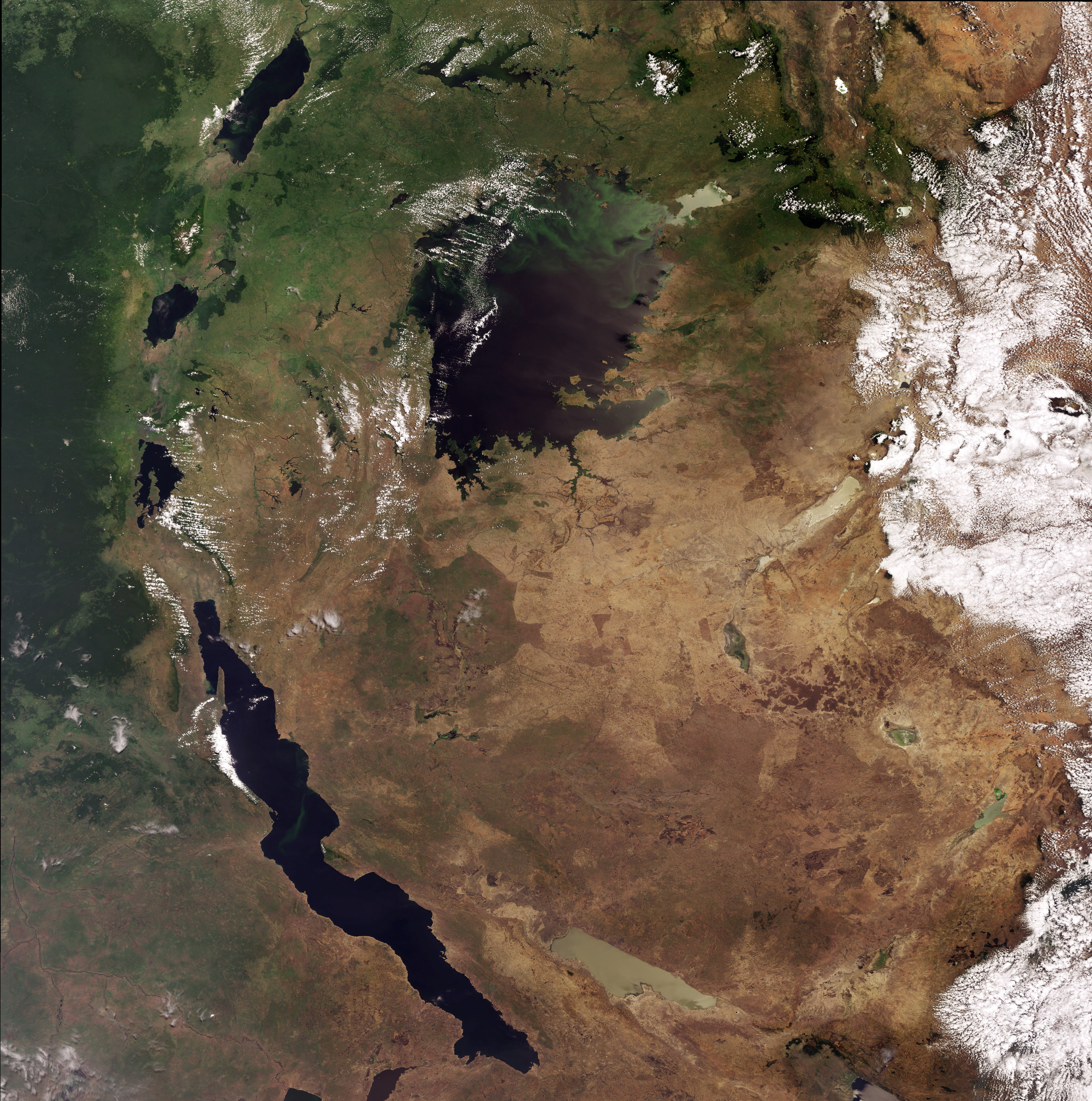
English: This Envisat image highlights lakes in the Western Rift of the Great Rift Valley, a geological fault system of Southwest Asia and East Africa: Lake Victoria, visible in the top centre, Kyoga, the lake above Victoria, Tanganyika, the oblong-shaped lake visible in the bottom left, Lake Albert, visible in the top left, Lake Edward, beneath Albert and Lake Kivu, beneath Edward. This image was acquired by Envisat's Medium Resolution Imaging Spectrometer (MERIS) on 6 October 2008, working in Full Resolution Mode providing a spatial resolution of 300 m. |
| Data | |
| Jatorria | http://www.esa.int/spaceinimages/Images/2008/10/Lakes_of_Africa |
| Egilea | European Space Agency |
| Lizentzia (Fitxategi hau berrerabiltzen) |
ESA,CC BY-SA 3.0 IGO |
| Beste bertsioak |
|
| Title | Lakes of Africa |
| Keywords | Water (fresh); Lakes |
| Set | Earth observation image of the week |
| Mission | Envisat |
| Activity | Observing the Earth |

Lizentzia
This file is licensed under the Creative Commons Attribution-ShareAlike 3.0 IGO license.
Aitortu: ESA
- Askea zara:
- partekatzeko – lana kopiatzeko, banatzeko eta bidaltzeko
- birnahasteko – lana moldatzeko
- Ondorengo baldintzen pean:
- eskuduntza – Egiletza behar bezala aitortu behar duzu, lizentzia ikusteko esteka gehitu, eta ea aldaketak egin diren aipatu. Era egokian egin behar duzu hori guztia, baina inola ere ez egileak zure lana edo zure erabilera babesten duela irudikatuz.
- berdin partekatu – Lan honetan oinarrituta edo aldatuta berria eraikitzen baduzu, emaitza lana hau bezalako lizentzia batekin argitaratu behar duzu.
Fitxategiaren historia
Data/orduan klik egin fitxategiak orduan zuen itxura ikusteko.
| Data/Ordua | Iruditxoa | Neurriak | Erabiltzailea | Iruzkina | |
|---|---|---|---|---|---|
| oraingoa | 07:25, 2 martxoa 2017 | | 4.261 × 4.296 (7,42 MB) | Revent | =={{int:filedesc}}== {{Photograph |photographer = Envisat satellite |title = Lakes of Africa |description = {{en|1=This Envisat image highlights lakes in the Western Rift of the Great Rift Valley, a geological fault system... |
Irudira dakarten loturak
Hurrengo orrialdeek dute fitxategi honetarako lotura:
Fitxategiaren erabilera orokorra
Hurrengo beste wikiek fitxategi hau darabilte:
- en.wikipedia.org proiektuan duen erabilera
- ro.wikipedia.org proiektuan duen erabilera
- Lacul Tanganyika
- Mozambic
- Tanzania
- Somalia
- Orientul Mijlociu
- Etiopia
- Madagascar
- Malawi
- Zambia
- Somaliland
- Rwanda
- Munții Ruwenzori
- Sahara
- Nil
- Deșertul Kalahari
- Marea Roșie
- Africa Centrală
- Lacul Victoria
- Munții Atlas
- Magreb
- Zona mediterană
- Sahel
- Sudan (regiune)
- Marile Lacuri Africane
- Africa Răsăriteană
- Africa Nordică
- Africa Sudică
- Africa Occidentală
- Africa Subsahariană
- Capul Palmas
- Golful Aden
- Listă de țări în care araba este limbă oficială
- Zambezi (fluviu)
- Rift
- Lacul Nyasa
- Lacul Tana
- Congo (fluviu)
- Tibesti
- Parcul Național Etosha
- Insulele Comore
- Parcul Național Serengeti
- Niger (fluviu)
- Darfur
- Arhipelagul Dahlak
- Delta Okavango
- Egiptul de Sus
- Egiptul de Jos
- Muntele Kenya
- Nubia
Ikus fitxategi honen erabilpen global gehiago.