Fitxategi:Kingdoms of Israel and Judah map 830-es.svg

SVG fitxategi honen PNG aurreikuspenaren tamaina: 503 × 600 pixel. Bestelako bereizmenak: 201 × 240 pixel | 402 × 480 pixel | 644 × 768 pixel | 858 × 1.024 pixel | 1.717 × 2.048 pixel | 768 × 916 pixel.
Bereizmen handikoa (SVG fitxategia, nominaldi 768 × 916 pixel, fitxategiaren tamaina: 393 KB)
Fitxategi hau Wikimedia Commonsekoa da. Hango deskribapen orriko informazioa behean duzu. |
| Deskribapena |
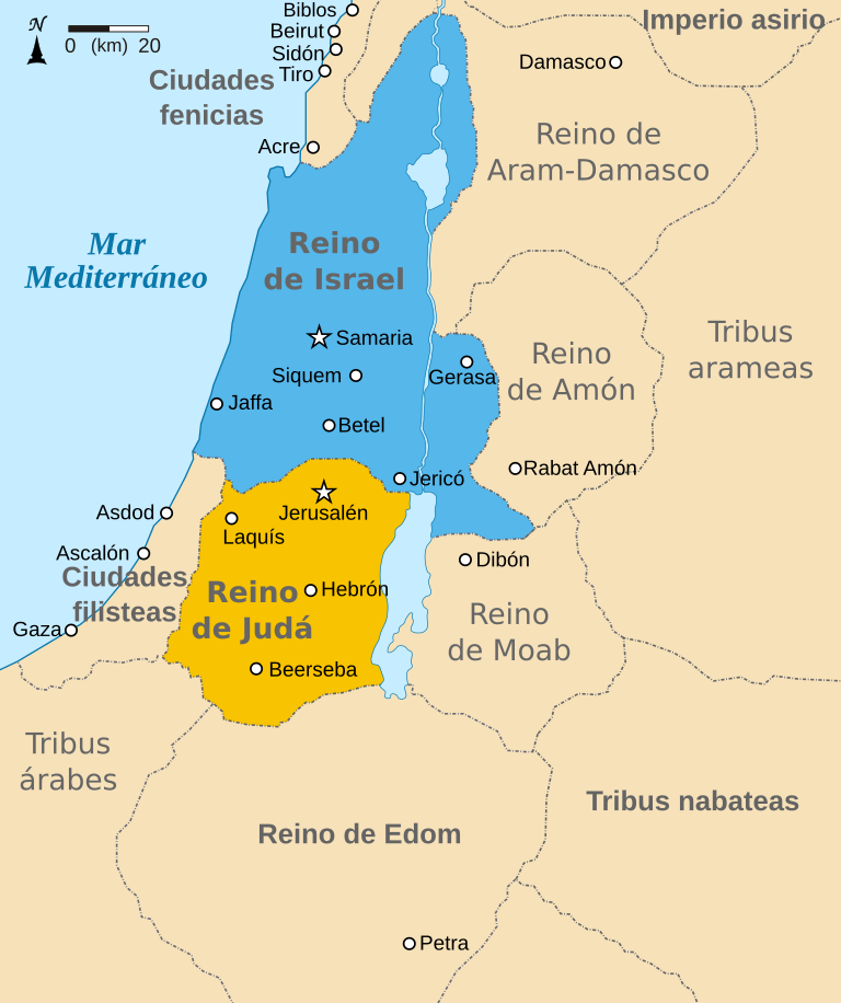
Español: Mapa mostrando los reinos de Israel (azul) y de Judá (naranja) showing the Kingdoms of Israel (blue) and Judah (orange), antiguas fronteras levantinas y ciudades como Damasco y Gerasa. El mapa muestra la región en torno al siglo IX a. C. |
| Data | (UTC) |
| Jatorria | |
| Egilea |
|
| Beste bertsioak |
[]
|


| This is a retouched picture, which means that it has been digitally altered from its original version. Modifications: translated to Spanish. The original can be viewed here: Kingdoms of Israel and Judah map 830.svg:
|
Nik, lan honen egileak, argitaratzen dut ondorengo lizentzia hauen pean:
Fitxategi hau Creative Commons Attribution-Share Alike 3.0 Unported lizentziapean dago.
- Askea zara:
- partekatzeko – lana kopiatzeko, banatzeko eta bidaltzeko
- birnahasteko – lana moldatzeko
- Ondorengo baldintzen pean:
- eskuduntza – Egiletza behar bezala aitortu behar duzu, lizentzia ikusteko esteka gehitu, eta ea aldaketak egin diren aipatu. Era egokian egin behar duzu hori guztia, baina inola ere ez egileak zure lana edo zure erabilera babesten duela irudikatuz.
- berdin partekatu – Lan honetan oinarrituta edo aldatuta berria eraikitzen baduzu, emaitza lana hau bezalako lizentzia batekin argitaratu behar duzu.

|
Baimena duzu dokumentu hau kopiatu, banatu edo/eta aldatzeko GNU Free Documentation License baldintzapean, Free Software Foundationek argitaratutako 1.2 edo ondorengo bertsioan; sekzio aldaezinik gabe, azaleko testurik gabe, eta atzeko azaleko testurik gabe. Lizentziaren kopia dago GNU Free Documentation License izenburudun atalean. |
Nahiago duzun lizentzia erabil dezakezu.
Jatorrizko igoera erregistroa
This image is a derivative work of the following images:
- File:Kingdoms_of_Israel_and_Judah_map_830.svg licensed with Cc-by-sa-3.0, GFDL
- 2010-07-13T11:29:47Z Richardprins 720x859 (80899 Bytes) Fixed Judah color
- 2010-07-13T10:51:49Z Richardprins 720x859 (80858 Bytes) Added colors for the two kingdoms and converted their text to path and arial
- 2010-07-12T23:53:35Z Richardprins 720x859 (63843 Bytes) Shrinked down the borders
- 2010-07-12T19:43:31Z Richardprins 720x859 (63800 Bytes) {{Information |Description={{en|1=Map showing the ancient levant borders and ancient cities such as [[Urmomium]] and [[Jerash]]. The map also shows the region in the 9th century BCE. Notice the coastal land of Philistia, from
Uploaded with derivativeFX
Fitxategiaren historia
Data/orduan klik egin fitxategiak orduan zuen itxura ikusteko.
| Data/Ordua | Iruditxoa | Neurriak | Erabiltzailea | Iruzkina | |
|---|---|---|---|---|---|
| oraingoa | 09:28, 20 martxoa 2017 | | 768 × 916 (393 KB) | Rowanwindwhistler | Fake text added |
| 20:22, 23 iraila 2010 |  | 720 × 859 (65 KB) | Kordas | {{Information |Description={{es|1=Mapa mostrando los reinos de Israel (azul) y de Judá (naranja) showing the Kingdoms of Israel (blue) and Judah (orange), antiguas fronteras levantinas y ciudades como Damasco y Gerasa. El mapa muestra la región en torno |
Irudira dakarten loturak
Hurrengo orrialdeek dute fitxategi honetarako lotura:
Fitxategiaren erabilera orokorra
Hurrengo beste wikiek fitxategi hau darabilte:
- ast.wikipedia.org proiektuan duen erabilera
- ca.wikipedia.org proiektuan duen erabilera
- es.wikipedia.org proiektuan duen erabilera
- gl.wikipedia.org proiektuan duen erabilera
- wuu.wikipedia.org proiektuan duen erabilera