Fitxategi:John-Speed-The-Kingdome-of-China-1626-2544.jpg

Bereizmen handikoa ((2.024 × 1.640 pixel, fitxategiaren tamaina: 3,98 MB, MIME mota: image/jpeg))
Fitxategi hau Wikimedia Commonsekoa da. Hango deskribapen orriko informazioa behean duzu. |
| Deskribapena |
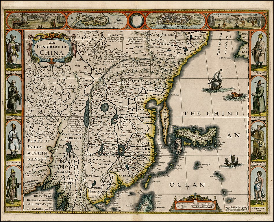
English: "The Kingdome of China", one of the first English-language maps of China. Note generally correct outline of the Ming China, with many provinces labeled (Cantam/Guangdong, Quancii/Guangxi, Chequiam/Zhejiang, Quicheu/Guizhou, Fuquam/en:Huguang/Huguang, Honao/Henan, Xanton/Shandong, Xiamxii and Sancii (Shanxi and Shaanxi?). "Xuntien alias Quinzay" more or less corresponds to Beijing (the name Shuntian Prefecture was indeed in use). However, north of China proper, John Speed had also placed "Cathaya, the Chief Kingdome of Great Cam", with the capital Cambalu (Khanbaliq - i.e., in fact, the same Beijing). This kind of duplication was common on the maps of the period, as geographers had not apparently yet fully identified Marco Polo's Cathay with the China then known to Europeans, and Cambalu with Beijing. |
|||||||||||||||||
| Data | Originally published 1626, reprint 1627 | |||||||||||||||||
| Jatorria |
English: An antique map from the Special Collection "China in Maps" of the Hong Kong University of Science and Technology Library, reproduced by the HKUST Library in the book "China in European Maps", Hong Kong, 2003. ISBN 962-86403-9-9.
Русский: Старинная карта из специальной коллекции Библиотеки Гонконгского научно-технического университета. Опубликована этой библиотекой в книге "China in European Maps" (Китай на европейских картах), Гонконг, 2003. ISBN 962-86403-9-9, тиражом 1000 экз. См. также каталог выставки, Special Collection "China in Maps".
Plate 21 |
|||||||||||||||||
| Egilea |
|
|||||||||||||||||
| Lizentzia (Fitxategi hau berrerabiltzen) |
Author died more than 70 years ago - public domain | |||||||||||||||||

|
Lan hau jabetza publikoan dago bai bere jatorrizko herrialdean, bai egile eskubideak egilea hil eta 70 urtera edo gutxiagora iraungitzen diren gainerako herrialdeetan.
| |
| This file has been identified as being free of known restrictions under copyright law, including all related and neighboring rights. | |
Fitxategiaren historia
Data/orduan klik egin fitxategiak orduan zuen itxura ikusteko.
| Data/Ordua | Iruditxoa | Neurriak | Erabiltzailea | Iruzkina | |
|---|---|---|---|---|---|
| oraingoa | 14:38, 28 urtarrila 2010 | | 2.024 × 1.640 (3,98 MB) | Vmenkov | better scan of same map, from http://www.raremaps.com/gallery/detail/22839/the_Kingdome_of_China_newly_augmented_by_IS_1626/Speed.html |
| 02:35, 22 martxoa 2009 |  | 2.560 × 1.920 (2,11 MB) | Vmenkov | {{Information |Description={{en|"The Kingdome of China", one of the first English-language maps of China. Note generally correct outline of the Ming China, with many provinces labeled (Cantam/Guangdong, Quancii/Guangxi, Chequiam/Zhejiang, Quicheu/Guizhou, |
Irudira dakarten loturak
Hurrengo orrialdeek dute fitxategi honetarako lotura:
Fitxategiaren erabilera orokorra
Hurrengo beste wikiek fitxategi hau darabilte:
- ar.wikipedia.org proiektuan duen erabilera
- arz.wikipedia.org proiektuan duen erabilera
- ast.wikipedia.org proiektuan duen erabilera
- bg.wikipedia.org proiektuan duen erabilera
- bn.wikipedia.org proiektuan duen erabilera
- ca.wikipedia.org proiektuan duen erabilera
- cv.wikipedia.org proiektuan duen erabilera
- de.wikivoyage.org proiektuan duen erabilera
- el.wikipedia.org proiektuan duen erabilera
- en.wikipedia.org proiektuan duen erabilera
- en.wikivoyage.org proiektuan duen erabilera
- es.wikipedia.org proiektuan duen erabilera
- fa.wikipedia.org proiektuan duen erabilera
- fi.wikipedia.org proiektuan duen erabilera
- fr.wikipedia.org proiektuan duen erabilera
- he.wikipedia.org proiektuan duen erabilera
- hu.wikipedia.org proiektuan duen erabilera
- hy.wikipedia.org proiektuan duen erabilera
- id.wikipedia.org proiektuan duen erabilera
- it.wikipedia.org proiektuan duen erabilera
- kk.wikipedia.org proiektuan duen erabilera
- ko.wikipedia.org proiektuan duen erabilera
- la.wikipedia.org proiektuan duen erabilera
- nl.wikipedia.org proiektuan duen erabilera
- nn.wikipedia.org proiektuan duen erabilera
- pl.wikipedia.org proiektuan duen erabilera
- pnb.wikipedia.org proiektuan duen erabilera
- pt.wikipedia.org proiektuan duen erabilera
- ru.wikipedia.org proiektuan duen erabilera
Ikus fitxategi honen erabilpen global gehiago.