Fitxategi:Island of Ireland location map Tyrone.svg

SVG fitxategi honen PNG aurreikuspenaren tamaina: 796 × 599 pixel. Bestelako bereizmenak: 319 × 240 pixel | 638 × 480 pixel | 1.020 × 768 pixel | 1.280 × 964 pixel | 2.560 × 1.928 pixel | 931 × 701 pixel.
Bereizmen handikoa (SVG fitxategia, nominaldi 931 × 701 pixel, fitxategiaren tamaina: 826 KB)
Fitxategi hau Wikimedia Commonsekoa da. Hango deskribapen orriko informazioa behean duzu. |
| Deskribapena |
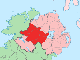
English: The island of Ireland, showing international border between Northern Ireland and Republic of Ireland, traditional provinces, traditional counties, and local authority areas in the Republic of Ireland and Northern Ireland. |
||
| Data | (UTC) | ||
| Jatorria | Island of Ireland location map.svg | ||
| Egilea | |||
| SVG genesis | Fitxategi hau (bektore-irudia) hau Adobe Illustrator-ekin sortu da .
|
Nik, lan honen egileak, argitaratzen dut ondorengo lizentzia pean:
Fitxategi hau Creative Commons Attribution-Share Alike 3.0 Unported lizentziapean dago.
- Askea zara:
- partekatzeko – lana kopiatzeko, banatzeko eta bidaltzeko
- birnahasteko – lana moldatzeko
- Ondorengo baldintzen pean:
- eskuduntza – Egiletza behar bezala aitortu behar duzu, lizentzia ikusteko esteka gehitu, eta ea aldaketak egin diren aipatu. Era egokian egin behar duzu hori guztia, baina inola ere ez egileak zure lana edo zure erabilera babesten duela irudikatuz.
- berdin partekatu – Lan honetan oinarrituta edo aldatuta berria eraikitzen baduzu, emaitza lana hau bezalako lizentzia batekin argitaratu behar duzu.
Jatorrizko igoera erregistroa
This image is a derivative work of the following images:
- Island of Ireland location map.svg licensed with Cc-by-sa-3.0
- 2010-03-06T20:43:33Z Rannpháirtí anaithnid 1450x1807 (679207 Bytes) Fix incorrectly coloured isands.
- 2010-03-03T22:19:29Z Rannpháirtí anaithnid 1450x1807 (679744 Bytes) {{Information |Description={{de|Positionskarte von [[:de:Irland|Irland]]}} Quadratische Plattkarte, N-S-Streckung 170 %. Geographische Begrenzung der Karte: * N: 55.6° N * S: 51.2° N * W: 11.0° W * O: 5.0° W {{en|Location
Uploaded with derivativeFX
Fitxategiaren historia
Data/orduan klik egin fitxategiak orduan zuen itxura ikusteko.
| Data/Ordua | Iruditxoa | Neurriak | Erabiltzailea | Iruzkina | |
|---|---|---|---|---|---|
| oraingoa | 14:53, 19 uztaila 2010 | | 931 × 701 (826 KB) | Mabuska | another attempt |
| 14:41, 19 uztaila 2010 |  | 931 × 701 (819 KB) | Mabuska | fixed boundaries | |
| 13:20, 19 uztaila 2010 |  | 934 × 712 (827 KB) | Mabuska | {{Information |Description={{en|The island of Ireland, showing international border between Northern Ireland and Republic of Ireland, traditional provinces, traditional counties, and local authority areas in the Republic of Ireland and Northern Ireland.}} |
Irudira dakarten loturak
100 orrik baino gehiagok darabilte fitxategi hau. Ondorengo zerrendan, fitxategi hau darabilten lehen 100 orriak besterik ez da ageri. Ikusgai duzu zerrenda osoa ere.
- Altamuskin
- Altishane
- Altmore
- Ardboe
- Ardstraw
- Artigarvan
- Augher
- Aughnacloy (Tyrone konderria)
- Ballygawley (Tyrone konderria)
- Ballymagorry
- Ballymully Glebe
- Benburb
- Beragh
- Brackaville
- Bready
- Brockagh
- Caledon (Tyrone konderria)
- Cappagh (Tyrone konderria)
- Carnteel
- Carrickmore
- Castlecaulfield
- Castlederg
- Clady (Tyrone konderria)
- Clanabogan
- Clogher
- Coagh
- Coalisland
- Cookstown
- Cranagh
- Creggan (Tyrone konderria)
- Derrycrin
- Derryloughan (Tyrone konderria)
- Derrytresk
- Donaghmore (Tyrone konderria)
- Donemana
- Dooish
- Douglas Bridge
- Dromore (Tyrone konderria)
- Drumkee
- Drumnakilly
- Drumquin
- Dungannon
- Dunnamore
- Edenderry (Tyrone konderria)
- Eglish
- Erganagh
- Eskra
- Evish
- Fintona
- Fivemiletown
- Galbally (Tyrone konderria)
- Garvaghey
- Garvetagh
- Gillygooly
- Glebe (Tyrone konderria)
- Glenmornan
- Gortaclare
- Gortin
- Granville (Tyrone konderria)
- Greencastle (Tyrone konderria)
- Kildress
- Killay (Tyrone konderria)
- Killen (Tyrone konderria)
- Killeter
- Killyclogher
- Killyman
- Kilskeery
- Knockmoyle
- Landahaussy
- Liscloon
- Loughmacrory
- Magheramason
- Moortown (Tyrone konderria)
- Mountfield (Tyrone konderria)
- Moy (Tyrone konderria)
- Moygashel
- Moylagh (Tyrone konderria)
- Newmills
- Newtownstewart
- Omagh
- Plumbridge
- Pomeroy (Tyrone konderria)
- Rock (Tyrone konderria)
- Rousky
- Sandholes
- Seskinore
- Shanmaghery
- Sion Mills
- Sixmilecross
- Spamount
- Stewartstown (Tyrone konderria)
- Strabane
- Tamnamore
- Tattyreagh
- Trillick
- Tullyhogue
- Tullywiggan
- Tyrone konderria
- Victoria Bridge (Tyrone konderria)
- Washing Bay
Ikusi fitxategi honen lotura gehiago.
Fitxategiaren erabilera orokorra
Hurrengo beste wikiek fitxategi hau darabilte:
- an.wikipedia.org proiektuan duen erabilera
- ar.wikipedia.org proiektuan duen erabilera
- ast.wikipedia.org proiektuan duen erabilera
- bg.wikipedia.org proiektuan duen erabilera
- ca.wikipedia.org proiektuan duen erabilera
- cs.wikipedia.org proiektuan duen erabilera
- de.wikipedia.org proiektuan duen erabilera
- en.wikipedia.org proiektuan duen erabilera
- es.wikipedia.org proiektuan duen erabilera
- fa.wikipedia.org proiektuan duen erabilera
- fi.wikipedia.org proiektuan duen erabilera
- fr.wikipedia.org proiektuan duen erabilera
- ga.wikipedia.org proiektuan duen erabilera
- gl.wikipedia.org proiektuan duen erabilera
- gv.wikipedia.org proiektuan duen erabilera
- ja.wikipedia.org proiektuan duen erabilera
- ko.wikipedia.org proiektuan duen erabilera
- mk.wikipedia.org proiektuan duen erabilera
- nl.wikipedia.org proiektuan duen erabilera
- pl.wikipedia.org proiektuan duen erabilera
- pl.wikivoyage.org proiektuan duen erabilera
- pnb.wikipedia.org proiektuan duen erabilera
- pt.wikipedia.org proiektuan duen erabilera
- ru.wikipedia.org proiektuan duen erabilera
- sco.wikipedia.org proiektuan duen erabilera
- simple.wikipedia.org proiektuan duen erabilera
- sk.wikipedia.org proiektuan duen erabilera
- sr.wikipedia.org proiektuan duen erabilera
- sv.wikipedia.org proiektuan duen erabilera
- th.wikipedia.org proiektuan duen erabilera
- tum.wikipedia.org proiektuan duen erabilera
- uk.wikipedia.org proiektuan duen erabilera
- ur.wikipedia.org proiektuan duen erabilera
- www.wikidata.org proiektuan duen erabilera
- zh-min-nan.wikipedia.org proiektuan duen erabilera
- zh.wikipedia.org proiektuan duen erabilera