Fitxategi:Iron Curtain map.svg

Bereizmen handikoa (SVG fitxategia, nominaldi 645 × 690 pixel, fitxategiaren tamaina: 322 KB)
Fitxategi hau Wikimedia Commonsekoa da. Hango deskribapen orriko informazioa behean duzu. |
Laburpena
| Deskribapena |
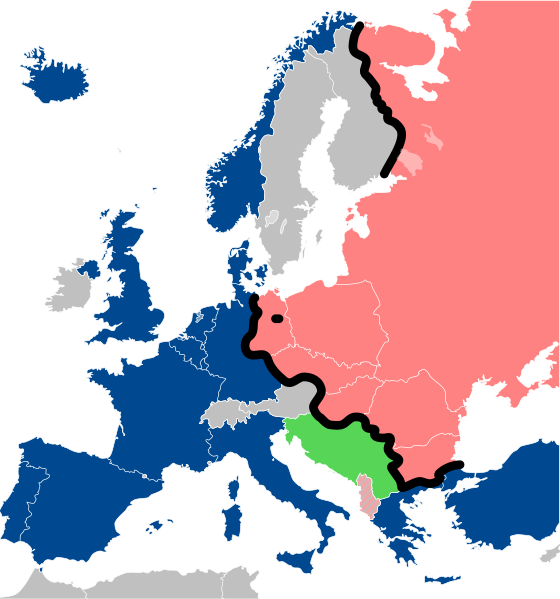
Lëtzebuergesch: Kaart vum Westen an dem Ostblock an Europa während dem Kale Krich.
"Eise Rido"
Neutral Länner
|
||
| Data | |||
| Jatorria |
Travail personnel (own work). Sources:
|
||
| Egilea | Sémhur | ||
| Beste bertsioak |
File:Iron Curtain map alternative.svg (Same, but with Yugoslavia on the Eastern side of the Iron Curtain.) | ||
| Aitortu (required by the license) | © Sémhur / Wikimedia Commons / | ||
| SVG | W3C-validity not checked. Fitxategi hau (bektore-irudia) hau Inkscape-ekin sortu da .
.
|
||
| Graphic Lab |

| Kameraren kokapena | | Irudi hau eta gehiago beraien kokapenekin hurrengo lekuetan: OpenStreetMap |
|---|
Lizentzia
| Copyleft: This work of art is free; you can redistribute it and/or modify it according to terms of the Free Art License. You will find a specimen of this license on the Copyleft Attitude site as well as on other sites. |
- Askea zara:
- partekatzeko – lana kopiatzeko, banatzeko eta bidaltzeko
- birnahasteko – lana moldatzeko
- Ondorengo baldintzen pean:
- eskuduntza – Egiletza behar bezala aitortu behar duzu, lizentzia ikusteko esteka gehitu, eta ea aldaketak egin diren aipatu. Era egokian egin behar duzu hori guztia, baina inola ere ez egileak zure lana edo zure erabilera babesten duela irudikatuz.
- berdin partekatu – Lan honetan oinarrituta edo aldatuta berria eraikitzen baduzu, emaitza lana hau bezalako lizentzia batekin argitaratu behar duzu.
Fitxategiaren historia
Data/orduan klik egin fitxategiak orduan zuen itxura ikusteko.
| Data/Ordua | Iruditxoa | Neurriak | Erabiltzailea | Iruzkina | |
|---|---|---|---|---|---|
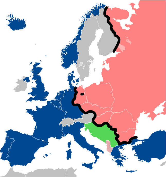
| oraingoa | 15:26, 15 abendua 2022 | | 645 × 690 (322 KB) | PhotographyEdits | Extend the Iron Curtain eastwards of Yugoslavia. Even though Yugoslavia was not really considered part of the West, the currenet map gives the false impression that there was a huge gap in the Iron Curtain, which wasn't the case. |
| 02:56, 23 uztaila 2022 |  | 645 × 690 (321 KB) | Kwamikagami | NATO blue, #004990 | |
| 22:30, 30 martxoa 2019 |  | 645 × 690 (321 KB) | Sémhur | Reverted to version as of 07:07, 27 May 2014 (UTC). Albania leaves the Waras Pack in middle of cold war; this is why it's shown wtih stripes. | |
| 11:18, 24 martxoa 2019 |  | 512 × 548 (123 KB) | Hakuli | Albania leaves the Waras Pack in middle of cold war | |
| 09:07, 27 maiatza 2014 |  | 645 × 690 (321 KB) | Sémhur | Valid SVG | |
| 15:51, 16 azaroa 2010 |  | 645 × 690 (321 KB) | Sémhur | Added Iron Curtain between Bulgaria and Greece & Turkey. | |
| 18:57, 27 iraila 2008 |  | 645 × 690 (321 KB) | Sémhur | Correcting mistake : Austria wasn't in NATO. | |
| 12:51, 31 maiatza 2008 |  | 645 × 690 (330 KB) | Sémhur | {{Information |Description={{en|1=Map of the Iron Curtain in Europe.}} {{fr|1=Carte du rideau de fer en Europe.}} {{es|1=Mapa del Telón de Acero en Europa.}} |Source=Travail personnel (ow |
Irudira dakarten loturak
Hurrengo orrialdeek dute fitxategi honetarako lotura:
Fitxategiaren erabilera orokorra
Hurrengo beste wikiek fitxategi hau darabilte:
- af.wikipedia.org proiektuan duen erabilera
- als.wikipedia.org proiektuan duen erabilera
- ar.wikipedia.org proiektuan duen erabilera
- ast.wikipedia.org proiektuan duen erabilera
- azb.wikipedia.org proiektuan duen erabilera
- az.wikipedia.org proiektuan duen erabilera
- ba.wikipedia.org proiektuan duen erabilera
- be-tarask.wikipedia.org proiektuan duen erabilera
- be.wikipedia.org proiektuan duen erabilera
- bg.wikipedia.org proiektuan duen erabilera
- br.wikipedia.org proiektuan duen erabilera
- bs.wikipedia.org proiektuan duen erabilera
- ca.wikipedia.org proiektuan duen erabilera
- cs.wikipedia.org proiektuan duen erabilera
- cy.wikipedia.org proiektuan duen erabilera
- da.wikipedia.org proiektuan duen erabilera
- de.wikipedia.org proiektuan duen erabilera
- el.wikipedia.org proiektuan duen erabilera
- el.wiktionary.org proiektuan duen erabilera
- en.wikipedia.org proiektuan duen erabilera
- en.wikibooks.org proiektuan duen erabilera
- en.wikiquote.org proiektuan duen erabilera
- en.wiktionary.org proiektuan duen erabilera
Ikus fitxategi honen erabilpen global gehiago.