Fitxategi:Iran-geographic map.svg

Bereizmen handikoa (SVG fitxategia, nominaldi 3.013 × 2.600 pixel, fitxategiaren tamaina: 12,7 MB)
Fitxategi hau Wikimedia Commonsekoa da. Hango deskribapen orriko informazioa behean duzu. |
Laburpena
| Deskribapena |
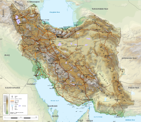
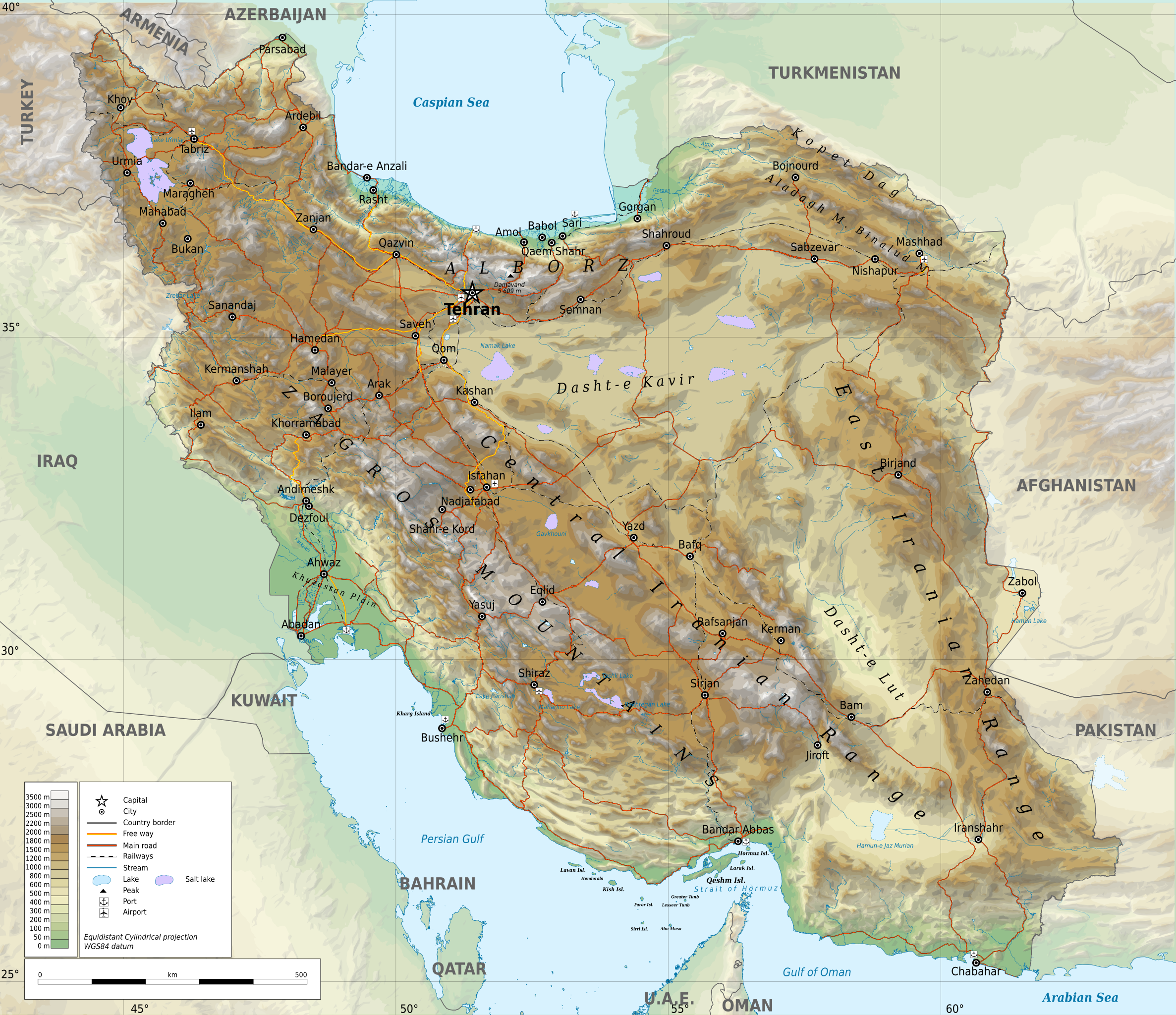
English: Geographic map of Iran. Limits of the map:
|
| Data | |
| Jatorria |
Norberak egina
|
| Egilea | Ikonact |
| Lizentzia (Fitxategi hau berrerabiltzen) |
Any use of this map is subject of the license(s) stated below with the condition that you credit (Wikimedia Commons user: Ikonact) as the author . A message with a reply address would also be greatly appreciated. |
| SVG genesis | handi Fitxategi hau (bektore-irudia) hau Inkscape-ekin sortu da . |
Lizentzia
| This work contains information from OpenStreetMap, which is made available under the Open Database License (ODbL).
The ODbL does not require any particular license for maps produced from ODbL data. Prior to 1 August 2020, map tiles produced by the OpenStreetMap Foundation were licensed under the CC-BY-SA-2.0 license. Maps produced by other people may be subject to other licences. |
- Askea zara:
- partekatzeko – lana kopiatzeko, banatzeko eta bidaltzeko
- birnahasteko – lana moldatzeko
- Ondorengo baldintzen pean:
- eskuduntza – Egiletza behar bezala aitortu behar duzu, lizentzia ikusteko esteka gehitu, eta ea aldaketak egin diren aipatu. Era egokian egin behar duzu hori guztia, baina inola ere ez egileak zure lana edo zure erabilera babesten duela irudikatuz.
- berdin partekatu – Lan honetan oinarrituta edo aldatuta berria eraikitzen baduzu, emaitza lana hau bezalako lizentzia batekin argitaratu behar duzu.
Assessment
|
Fitxategiaren historia
Data/orduan klik egin fitxategiak orduan zuen itxura ikusteko.
| Data/Ordua | Iruditxoa | Neurriak | Erabiltzailea | Iruzkina | |
|---|---|---|---|---|---|
| oraingoa | 23:45, 20 iraila 2023 | | 3.013 × 2.600 (12,7 MB) | Socialdilema | File uploaded using svgtranslate tool (https://svgtranslate.toolforge.org/). Added translation for ca. |
| 19:25, 20 iraila 2023 |  | 3.013 × 2.600 (12,69 MB) | Socialdilema | File uploaded using svgtranslate tool (https://svgtranslate.toolforge.org/). Added translation for ca. | |
| 19:22, 20 iraila 2023 |  | 3.013 × 2.600 (12,68 MB) | Socialdilema | File uploaded using svgtranslate tool (https://svgtranslate.toolforge.org/). Added translation for ca. | |
| 16:08, 8 maiatza 2020 |  | 3.013 × 2.600 (12,62 MB) | Yamaha5 | File uploaded using svgtranslate tool (https://tools.wmflabs.org/svgtranslate/). Added translation for fa. | |
| 22:44, 1 maiatza 2020 |  | 3.013 × 2.600 (12,62 MB) | Ikonact | + hidden Text: MW workaround for displaying translations | |
| 22:43, 1 maiatza 2020 |  | 3.013 × 2.600 (12,62 MB) | Ikonact | + hidden Text: MW workaround for displaying translations | |
| 22:39, 1 maiatza 2020 |  | 3.013 × 2.600 (12,62 MB) | Ikonact | File uploaded using svgtranslate tool (https://tools.wmflabs.org/svgtranslate/). Added translation for bg. | |
| 22:01, 1 maiatza 2020 |  | 3.013 × 2.600 (12,55 MB) | Ikonact | + hidden Text: MW workaround for displaying translations | |
| 23:49, 30 apirila 2020 |  | 3.013 × 2.600 (12,55 MB) | Ahmad252 | File uploaded using svgtranslate tool (https://tools.wmflabs.org/svgtranslate/). Added translation for fa. | |
| 23:10, 30 apirila 2020 |  | 3.013 × 2.600 (13,24 MB) | Ikonact | + legend |
Irudira dakarten loturak
Hurrengo orrialdeek dute fitxategi honetarako lotura:
Fitxategiaren erabilera orokorra
Hurrengo beste wikiek fitxategi hau darabilte:
- ar.wikipedia.org proiektuan duen erabilera
- ast.wikipedia.org proiektuan duen erabilera
- avk.wikipedia.org proiektuan duen erabilera
- az.wikipedia.org proiektuan duen erabilera
- bg.wikipedia.org proiektuan duen erabilera
- bn.wikipedia.org proiektuan duen erabilera
- ca.wikipedia.org proiektuan duen erabilera
- ckb.wikipedia.org proiektuan duen erabilera
- cs.wikipedia.org proiektuan duen erabilera
- da.wikipedia.org proiektuan duen erabilera
- diq.wikipedia.org proiektuan duen erabilera
- el.wikipedia.org proiektuan duen erabilera
- en.wikipedia.org proiektuan duen erabilera
- eo.wikipedia.org proiektuan duen erabilera
- fa.wikipedia.org proiektuan duen erabilera
- جغرافیای ایران
- کاربر:Alieseraj
- توپوگرافی
- کاربر:مام وطن
- کاربر:Basp1
- کاربر:جعبه کاربر/مدافع خاک ایران
- کاربر:Gshahali
- بحث کاربر:Zzvf
- کاربر:Hamid Hassani
- کاربر:Derakhshan
- کاربر:Wiki center
- ویکیپدیا:گزیدن نگاره برگزیده/مه-۲۰۲۰
- کاربر:Arian.ramin
- ویکیپدیا:قهوهخانه/فنی/بایگانی ۶۵
- ویکیپدیا:گزیدن نگاره برگزیده/Iran-geographic map.svg
- کاربر:Adel2020
- ویکیپدیا:نگاره روز/اوت ۲۰۲۲
- کاربر:Amdanesh
- کاربر:Adolfzl64
- الگو:نر/2022-08-18
Ikus fitxategi honen erabilpen global gehiago.