Fitxategi:Ionian Revolt Campaign Map.png
Aurreikuspen honen neurria: 493 × 599 pixel. Bestelako bereizmenak: 197 × 240 pixel | 395 × 480 pixel | 632 × 768 pixel | 842 × 1.024 pixel | 1.645 × 2.000 pixel.
Bereizmen handikoa ((1.645 × 2.000 pixel, fitxategiaren tamaina: 4,24 MB, MIME mota: image/png))
Fitxategi hau Wikimedia Commonsekoa da. Hango deskribapen orriko informazioa behean duzu. |
| Deskribapena |
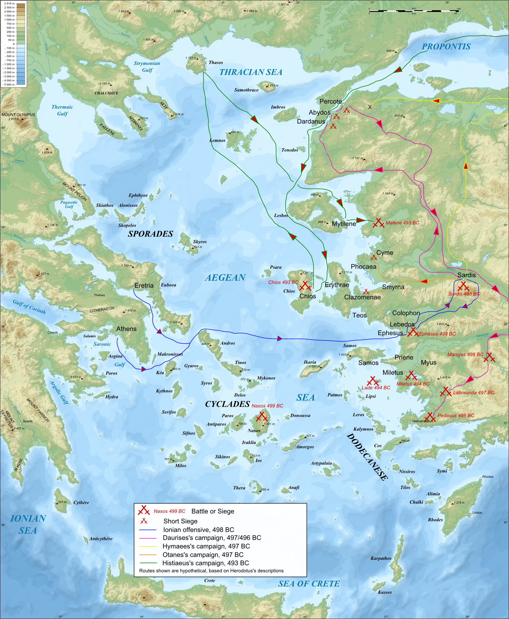
English: Bathymetric/Topographical map of the Aegean area in c.500 BC, showing major events of the Ionian Revolt.
|
| Data | (UTC) |
| Jatorria | |
| Egilea |
|
| Beste bertsioak |
|


| This is a retouched picture, which means that it has been digitally altered from its original version. Modifications: Modified map to more ancient names, and constructed campaign map of Ionina revolt. The original can be viewed here: Aegean Sea map bathymetry-fr.svg:
|
Nik, lan honen egileak, argitaratzen dut ondorengo lizentzia hauen pean:
This file is licensed under the Creative Commons Attribution-Share Alike 3.0 Unported, 2.5 Generic, 2.0 Generic and 1.0 Generic license.
- Askea zara:
- partekatzeko – lana kopiatzeko, banatzeko eta bidaltzeko
- birnahasteko – lana moldatzeko
- Ondorengo baldintzen pean:
- eskuduntza – Egiletza behar bezala aitortu behar duzu, lizentzia ikusteko esteka gehitu, eta ea aldaketak egin diren aipatu. Era egokian egin behar duzu hori guztia, baina inola ere ez egileak zure lana edo zure erabilera babesten duela irudikatuz.
- berdin partekatu – Lan honetan oinarrituta edo aldatuta berria eraikitzen baduzu, emaitza lana hau bezalako lizentzia batekin argitaratu behar duzu.

|
Baimena duzu dokumentu hau kopiatu, banatu edo/eta aldatzeko GNU Free Documentation License baldintzapean, Free Software Foundationek argitaratutako 1.2 edo ondorengo bertsioan; sekzio aldaezinik gabe, azaleko testurik gabe, eta atzeko azaleko testurik gabe. Lizentziaren kopia dago GNU Free Documentation License izenburudun atalean. |
Nahiago duzun lizentzia erabil dezakezu.
Jatorrizko igoera erregistroa
This image is a derivative work of the following images:
- File:Aegean_Sea_map_bathymetry-fr.svg licensed with Cc-by-sa-3.0,2.5,2.0,1.0, GFDL
- 2009-02-08T00:35:16Z Sting 3750x4560 (3597775 Bytes) Correcting display bug - new try - step #2
- 2009-02-08T00:29:02Z Sting 3750x4560 (410188 Bytes) Correcting display bug - new try - step #1
- 2009-02-08T00:14:50Z Sting 3750x4560 (3740562 Bytes) Correcting display bug
- 2009-02-06T07:54:54Z Future Perfect at Sunrise 3750x4560 (3742390 Bytes) null edit, re-uploading to try to force display to be reset, background image wasn't displaying
- 2009-02-06T07:52:12Z Future Perfect at Sunrise 3750x4560 (3742390 Bytes) null edit, re-uploading to try to force display to be reset, background image wasn't displaying
- 2008-09-28T21:11:49Z Sting 3750x4560 (3742390 Bytes) Completely new background using ETOPO1 data ; new standard colors ; some additional labels
- 2007-11-27T13:16:40Z Sting 3750x4560 (4078448 Bytes) Elevation on Chios
- 2007-11-26T23:25:43Z Sting 3750x4560 (4078446 Bytes) correction
- 2007-11-21T22:42:53Z Sting 3750x4560 (4079234 Bytes) Additional sea names
- 2007-11-21T20:21:26Z Sting 3750x4560 (4078039 Bytes) Additional key
- 2007-11-21T19:10:35Z Sting 3750x4560 (4072878 Bytes) {{Information |Description=Bathymetric map in French of the [[:Category:Aegean Sea|Aegean Sea]], Mediterranean Sea |Source=Own work ;Raster relief background map : [http://www2.jpl.nasa.gov/srtm NASA Shuttle Radar Topography
Uploaded with derivativeFX
Fitxategiaren historia
Data/orduan klik egin fitxategiak orduan zuen itxura ikusteko.
| Data/Ordua | Iruditxoa | Neurriak | Erabiltzailea | Iruzkina | |
|---|---|---|---|---|---|
| oraingoa | 08:35, 23 apirila 2009 | | 1.645 × 2.000 (4,24 MB) | MinisterForBadTimes | {{Information |Description=40px '''Note:''' this SVG map has a display bug on this page (size too large?) but works fine in Inkscape. Consider using the raster version in the art |
Irudira dakarten loturak
Hurrengo orrialdeek dute fitxategi honetarako lotura:
Fitxategiaren erabilera orokorra
Hurrengo beste wikiek fitxategi hau darabilte:
- azb.wikipedia.org proiektuan duen erabilera
- ca.wikipedia.org proiektuan duen erabilera
- el.wikipedia.org proiektuan duen erabilera
- en.wikipedia.org proiektuan duen erabilera
- fa.wikipedia.org proiektuan duen erabilera
- fr.wikipedia.org proiektuan duen erabilera
- hr.wikipedia.org proiektuan duen erabilera
- hy.wikipedia.org proiektuan duen erabilera
- id.wikipedia.org proiektuan duen erabilera
- it.wikipedia.org proiektuan duen erabilera
- it.wikiversity.org proiektuan duen erabilera
- ko.wikipedia.org proiektuan duen erabilera
- pl.wikipedia.org proiektuan duen erabilera
- pnb.wikipedia.org proiektuan duen erabilera
- pt.wikipedia.org proiektuan duen erabilera
- ru.wikipedia.org proiektuan duen erabilera
- sh.wikipedia.org proiektuan duen erabilera
- ta.wikipedia.org proiektuan duen erabilera
- tr.wikipedia.org proiektuan duen erabilera
- uk.wikipedia.org proiektuan duen erabilera
- ur.wikipedia.org proiektuan duen erabilera
- zh.wikipedia.org proiektuan duen erabilera