Fitxategi:Ionian Islands.svg

SVG fitxategi honen PNG aurreikuspenaren tamaina: 532 × 547 pixel. Bestelako bereizmenak: 233 × 240 pixel | 467 × 480 pixel | 747 × 768 pixel | 996 × 1.024 pixel | 1.992 × 2.048 pixel.
Bereizmen handikoa (SVG fitxategia, nominaldi 532 × 547 pixel, fitxategiaren tamaina: 281 KB)
Fitxategi hau Wikimedia Commonsekoa da. Hango deskribapen orriko informazioa behean duzu. |

|
This map has been uploaded by Electionworld from en.wikipedia.org to enable the |
Laburpena
| Deskribapena |
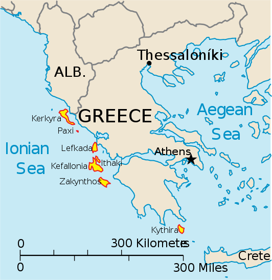
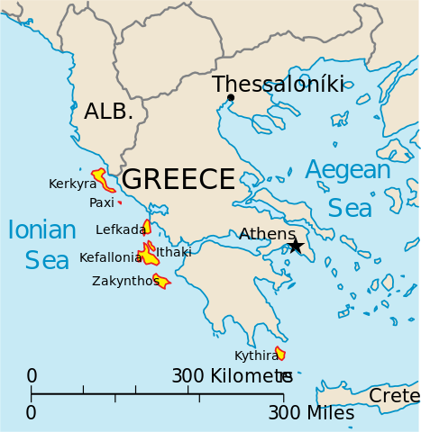
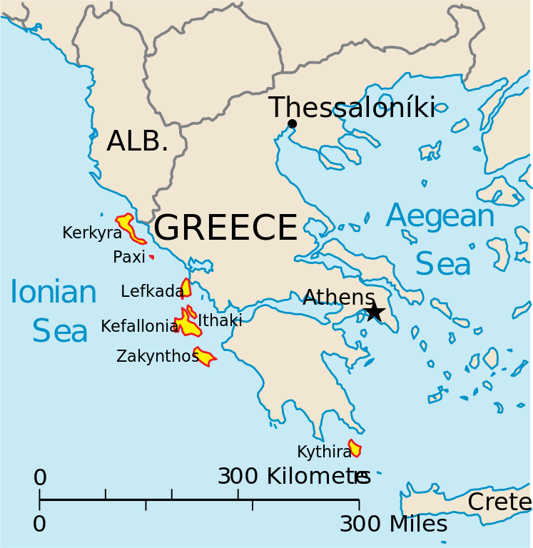
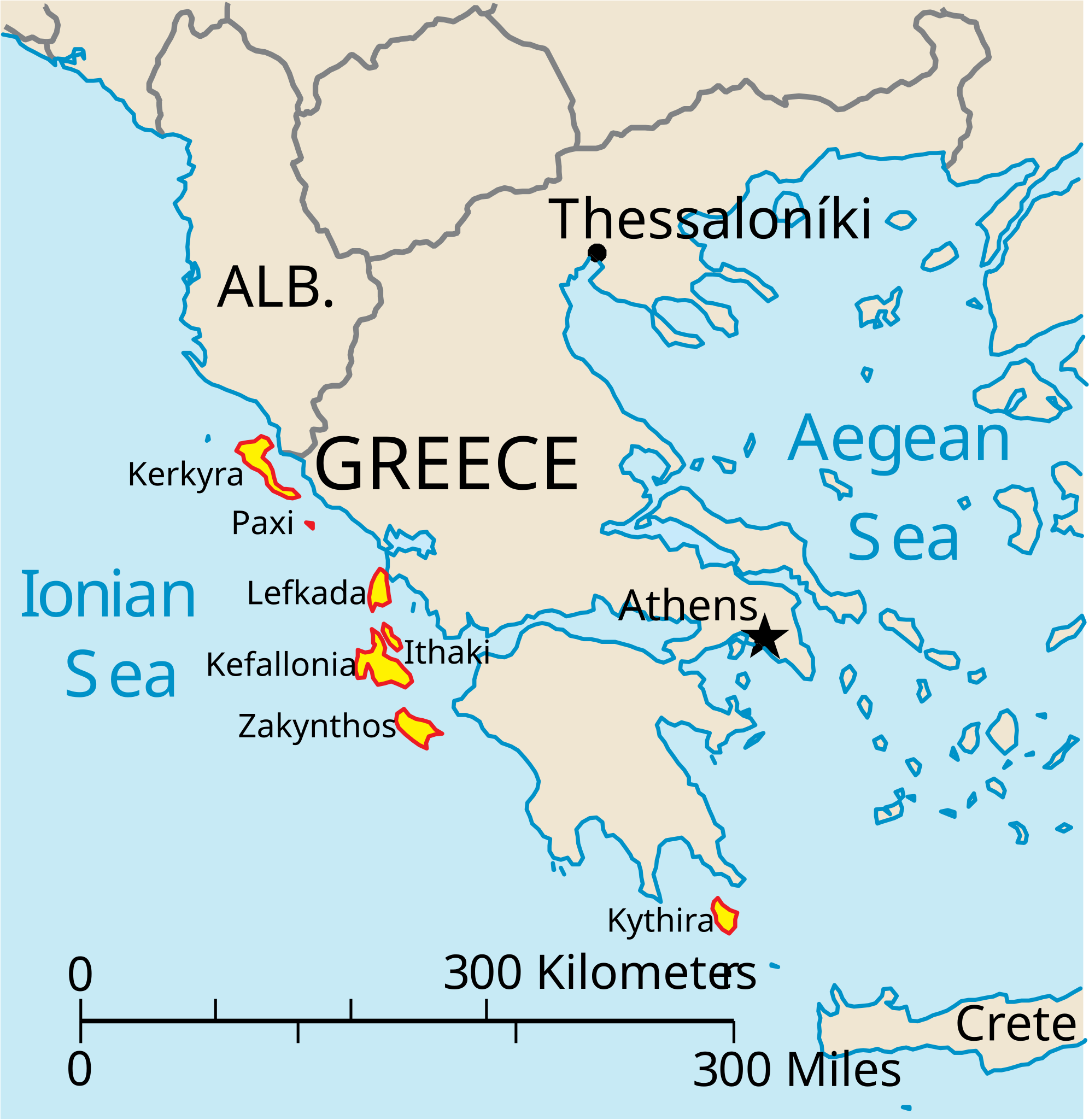
English: Map of the Ionian Islands off Greece. |
| Data | |
| Jatorria | Norberak egina, Original vector data taken from the 2006 CIA World Factbook map of Europe. All modifications were made by me, and are free for anyone to use for any purpose. |
| Egilea | Electionworld |
| Beste bertsioak |
Version en français : |
Lizentzia
This image is in the public domain because it contains materials that originally came from the United States Central Intelligence Agency's World Factbook.
|
 |
Fitxategiaren historia
Data/orduan klik egin fitxategiak orduan zuen itxura ikusteko.
| Data/Ordua | Iruditxoa | Neurriak | Erabiltzailea | Iruzkina | |
|---|---|---|---|---|---|
| oraingoa | 16:39, 4 apirila 2010 | | 532 × 547 (281 KB) | Kmusser | rm Macedonia label, not important to the map and avoids POV issue |
| 22:17, 20 abendua 2006 |  | 532 × 547 (258 KB) | Electionworld | {{ew|en|IMeowbot}} == Summary == Map of the Ionian Islands off Greece. Original vector data taken from the 2006 CIA World Factbook map of Europe. All modifications were made by me, and are free for anyone to use for any purpose. == Licensing == {{PD-US |
Irudira dakarten loturak
Ez dago fitxategi hau darabilen orririk.
Fitxategiaren erabilera orokorra
Hurrengo beste wikiek fitxategi hau darabilte:
- ar.wikipedia.org proiektuan duen erabilera
- ast.wikipedia.org proiektuan duen erabilera
- be.wikipedia.org proiektuan duen erabilera
- bg.wikipedia.org proiektuan duen erabilera
- ceb.wikipedia.org proiektuan duen erabilera
- ce.wikipedia.org proiektuan duen erabilera
- cy.wikipedia.org proiektuan duen erabilera
- da.wikipedia.org proiektuan duen erabilera
- de.wikipedia.org proiektuan duen erabilera
- en.wikipedia.org proiektuan duen erabilera
- et.wikipedia.org proiektuan duen erabilera
- fa.wikipedia.org proiektuan duen erabilera
- fi.wikipedia.org proiektuan duen erabilera
- fr.wikipedia.org proiektuan duen erabilera
- he.wikipedia.org proiektuan duen erabilera
- hr.wikipedia.org proiektuan duen erabilera
- hu.wikipedia.org proiektuan duen erabilera
- hyw.wikipedia.org proiektuan duen erabilera
- id.wikipedia.org proiektuan duen erabilera
- it.wikipedia.org proiektuan duen erabilera
Ikus fitxategi honen erabilpen global gehiago.