Fitxategi:Illogan Highway Methodist Church and Church Hall - geograph.org.uk - 1185643.jpg
Aurreikuspen honen neurria: 509 × 600 pixel. Bestelako bereizmenak: 204 × 240 pixel | 543 × 640 pixel.
Bereizmen handikoa ((543 × 640 pixel, fitxategiaren tamaina: 78 KB, MIME mota: image/jpeg))
Fitxategi hau Wikimedia Commonsekoa da. Hango deskribapen orriko informazioa behean duzu. |
Laburpena
| Deskribapena |
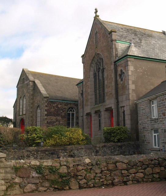
English: Illogan Highway Methodist Church and Church Hall These are the second and third Methodist chapels on this site; the first, dating from 1809, is a very modest single-storey building at the rear that is now the Sunday School. The further building dates from 1839 and is now a "meeting hall and Sunday School". See https://historicengland.org.uk/listing/the-list/list-entry/1328135 . The nearer building, of the early C20, has a "two-storey facade in free Gothic (or Arts and Crafts) style, in a form probably derived from that of its 1839 predecessor ..." https://historicengland.org.uk/listing/the-list/list-entry/1160343. Thomas Merritt, who composed several Christmas carols, including "Hark the Glad Sound! The Saviour Comes" and "Lo! He Comes, an Infant Stranger" was organist here from 1889 until his death in 1908.
All three buildings are built of killas, or metamorphic rock. |
| Data | |
| Jatorria | From geograph.org.uk |
| Egilea | Derek Harper |
| Aitortu (required by the license) | Derek Harper / Illogan Highway Methodist Church and Church Hall / |
| Kameraren kokapena | | Irudi hau eta gehiago beraien kokapenekin hurrengo lekuetan: OpenStreetMap |
|---|
_heading:112.00&language=eu)
| Objektuaren kokapena | | Irudi hau eta gehiago beraien kokapenekin hurrengo lekuetan: OpenStreetMap |
|---|
_heading:112.00&language=eu)
Lizentzia

|
This image was taken from the Geograph project collection. See this photograph's page on the Geograph website for the photographer's contact details. The copyright on this image is owned by Derek Harper and is licensed for reuse under the Creative Commons Attribution-ShareAlike 2.0 license.
|
This file is licensed under the Creative Commons Attribution-Share Alike 2.0 Generic license.
Aitortu: Derek Harper
- Askea zara:
- partekatzeko – lana kopiatzeko, banatzeko eta bidaltzeko
- birnahasteko – lana moldatzeko
- Ondorengo baldintzen pean:
- eskuduntza – Egiletza behar bezala aitortu behar duzu, lizentzia ikusteko esteka gehitu, eta ea aldaketak egin diren aipatu. Era egokian egin behar duzu hori guztia, baina inola ere ez egileak zure lana edo zure erabilera babesten duela irudikatuz.
- berdin partekatu – Lan honetan oinarrituta edo aldatuta berria eraikitzen baduzu, emaitza lana hau bezalako lizentzia batekin argitaratu behar duzu.
Fitxategiaren historia
Data/orduan klik egin fitxategiak orduan zuen itxura ikusteko.
| Data/Ordua | Iruditxoa | Neurriak | Erabiltzailea | Iruzkina | |
|---|---|---|---|---|---|
| oraingoa | 23:03, 25 otsaila 2011 | | 543 × 640 (78 KB) | GeographBot | == {{int:filedesc}} == {{Information |description={{en|1=Illogan Highway Methodist Church and Church Hall These are the second and third Methodist chapels on this site; the first, dating from 1809, is a very modest single-storey building at the rear that |
Irudira dakarten loturak
Hurrengo orrialdeek dute fitxategi honetarako lotura:
Fitxategiaren erabilera orokorra
Hurrengo beste wikiek fitxategi hau darabilte:
- en.wikipedia.org proiektuan duen erabilera