Fitxategi:Ile Mysterieuse 03.jpg

Bereizmen handikoa ((1.443 × 2.208 pixel, fitxategiaren tamaina: 751 KB, MIME mota: image/jpeg))
Fitxategi hau Wikimedia Commonsekoa da. Hango deskribapen orriko informazioa behean duzu. |
Laburpena
| Deskribapena |
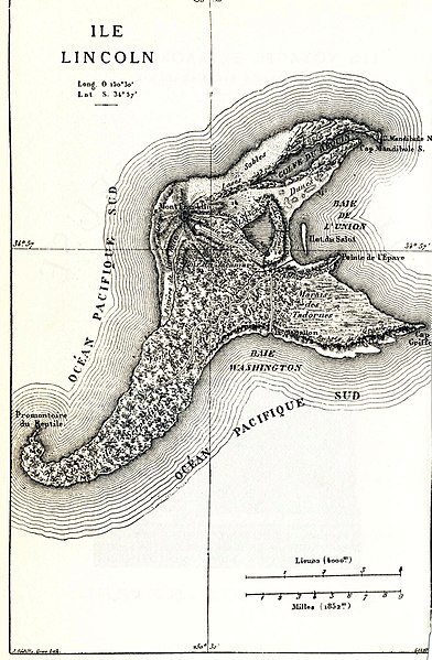
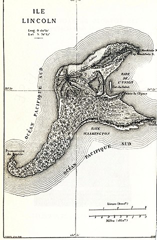
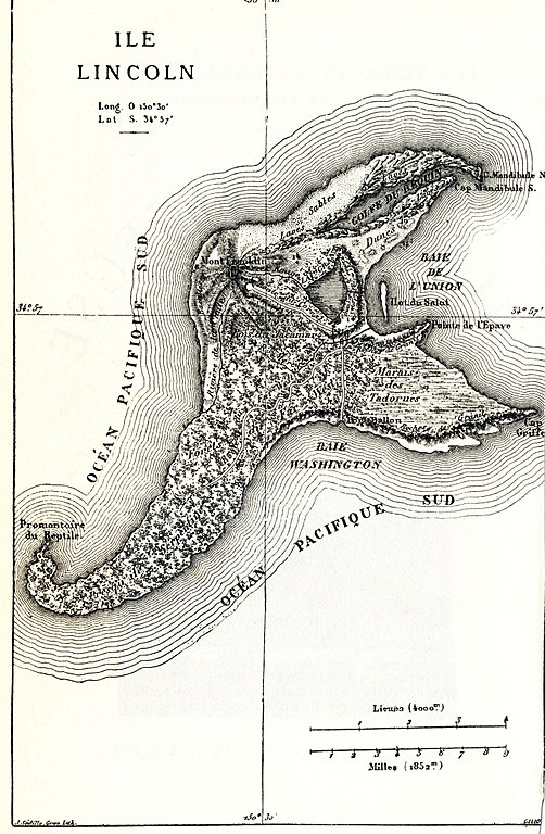
English: Map of the fictional Lincoln Island (The Mysterious Island). |
|||||||||||||||||||||||||||||||||||||||||||||||||||||||||||||||||||||
| Data | ||||||||||||||||||||||||||||||||||||||||||||||||||||||||||||||||||||||
| Jatorria |
English: This image was originally featured in the Hetzel edition of Mysterious Island, and has also been featured in more recent editions (this particular instance was scanned from a recent edition). |
|||||||||||||||||||||||||||||||||||||||||||||||||||||||||||||||||||||
| Egilea |
|
|||||||||||||||||||||||||||||||||||||||||||||||||||||||||||||||||||||
| Lizentzia (Fitxategi hau berrerabiltzen) |
This is a French work. French law applies. France does not use the notion of "copyright", but a "Droit d'auteur" system. They are now the public domain, since their Droit d'auteur is expired. | |||||||||||||||||||||||||||||||||||||||||||||||||||||||||||||||||||||
| Beste bertsioak |
|
|||||||||||||||||||||||||||||||||||||||||||||||||||||||||||||||||||||


| Kameraren kokapena | | Irudi hau eta gehiago beraien kokapenekin hurrengo lekuetan: OpenStreetMap |
|---|
Lizentzia
|
Lan hau jabetza publikoan dago bai bere jatorrizko herrialdean, bai egile eskubideak egilea hil eta 100 urtera edo gutxiagora iraungitzen diren gainerako herrialdeetan. This work is in the public domain in the United States because it was published (or registered with the U.S. Copyright Office) before January 1, 1929. | |
| This file has been identified as being free of known restrictions under copyright law, including all related and neighboring rights. | |
Fitxategiaren historia
Data/orduan klik egin fitxategiak orduan zuen itxura ikusteko.
| Data/Ordua | Iruditxoa | Neurriak | Erabiltzailea | Iruzkina | |
|---|---|---|---|---|---|
| oraingoa | 15:57, 10 abuztua 2017 | | 1.443 × 2.208 (751 KB) | The RedBurn | Levels corrected with XnView |
| 23:41, 25 otsaila 2005 |  | 1.443 × 2.208 (664 KB) | Rama | {{PD}} |
Irudira dakarten loturak
Hurrengo orrialdeek dute fitxategi honetarako lotura:
Fitxategiaren erabilera orokorra
Hurrengo beste wikiek fitxategi hau darabilte:
- bn.wikipedia.org proiektuan duen erabilera
- cs.wikipedia.org proiektuan duen erabilera
- da.wikipedia.org proiektuan duen erabilera
- de.wikipedia.org proiektuan duen erabilera
- en.wikipedia.org proiektuan duen erabilera
- es.wikipedia.org proiektuan duen erabilera
- et.wikipedia.org proiektuan duen erabilera
- fr.wikipedia.org proiektuan duen erabilera
- fr.wikisource.org proiektuan duen erabilera
- gl.wikipedia.org proiektuan duen erabilera
- he.wikipedia.org proiektuan duen erabilera
- hr.wikipedia.org proiektuan duen erabilera
- it.wikipedia.org proiektuan duen erabilera
- it.wikisource.org proiektuan duen erabilera
- ja.wikipedia.org proiektuan duen erabilera
- nl.wikipedia.org proiektuan duen erabilera
- ro.wikipedia.org proiektuan duen erabilera
- sr.wikipedia.org proiektuan duen erabilera
- uk.wikipedia.org proiektuan duen erabilera
- vi.wikipedia.org proiektuan duen erabilera
- www.wikidata.org proiektuan duen erabilera
- zh.wikipedia.org proiektuan duen erabilera