Fitxategi:Hungary topographic map.jpg
Aurreikuspen honen neurria: 800 × 549 pixel. Bestelako bereizmenak: 320 × 220 pixel | 640 × 439 pixel | 912 × 626 pixel.
Bereizmen handikoa ((912 × 626 pixel, fitxategiaren tamaina: 75 KB, MIME mota: image/jpeg))
Fitxategi hau Wikimedia Commonsekoa da. Hango deskribapen orriko informazioa behean duzu. |
Laburpena
| Deskribapena |
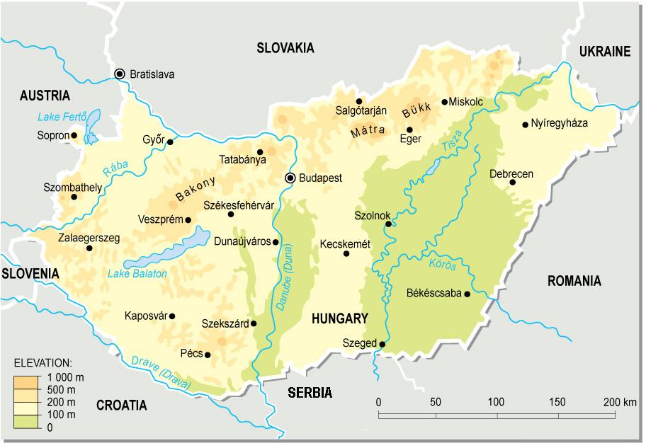
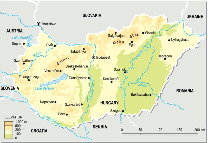
English: Topographic map of Hungary.
Deutsch: Topografische Karte Ungarns. |
| Data | |
| Jatorria | Norberak egina (from a PD map collection. Mistakes fixed) |
| Egilea | Cserlajos |
| Beste bertsioak |
|


|
This map has been uploaded by Electionworld from en.wikipedia.org to enable the |


Lizentzia
| This work has been released into the public domain by its author, Cserlajos. This applies worldwide. Estatu batzuetan beharbada hori ez da legez posible izango. Halakoetan: |
Fitxategiaren historia
Data/orduan klik egin fitxategiak orduan zuen itxura ikusteko.
| Data/Ordua | Iruditxoa | Neurriak | Erabiltzailea | Iruzkina | |
|---|---|---|---|---|---|
| oraingoa | 01:51, 24 abendua 2006 | | 912 × 626 (75 KB) | Electionworld | {{ew|en|Cserlajos}} == Summary == From a pd map collection. Mistakes fixed by User:cserlajos. == Licensing == {{no rights reserved}} |
Irudira dakarten loturak
Hurrengo orrialdeek dute fitxategi honetarako lotura:
Fitxategiaren erabilera orokorra
Hurrengo beste wikiek fitxategi hau darabilte:
- azb.wikipedia.org proiektuan duen erabilera
- az.wikipedia.org proiektuan duen erabilera
- be-tarask.wikipedia.org proiektuan duen erabilera
- bg.wikipedia.org proiektuan duen erabilera
- bn.wikipedia.org proiektuan duen erabilera
- bs.wikipedia.org proiektuan duen erabilera
- cs.wikipedia.org proiektuan duen erabilera
- da.wikipedia.org proiektuan duen erabilera
- de.wikipedia.org proiektuan duen erabilera
- de.wikibooks.org proiektuan duen erabilera
- en.wikipedia.org proiektuan duen erabilera
- fa.wikipedia.org proiektuan duen erabilera
- fi.wikipedia.org proiektuan duen erabilera
- fr.wikipedia.org proiektuan duen erabilera
- gl.wikipedia.org proiektuan duen erabilera
- gom.wikipedia.org proiektuan duen erabilera
- he.wikipedia.org proiektuan duen erabilera
- hr.wikipedia.org proiektuan duen erabilera
- hr.wiktionary.org proiektuan duen erabilera
- hu.wikipedia.org proiektuan duen erabilera
- hu.wikibooks.org proiektuan duen erabilera
- io.wikipedia.org proiektuan duen erabilera
- is.wikipedia.org proiektuan duen erabilera
Ikus fitxategi honen erabilpen global gehiago.