Fitxategi:Hawaii Island topographic map-fr.svg

Bereizmen handikoa (SVG fitxategia, nominaldi 3.110 × 2.563 pixel, fitxategiaren tamaina: 2,11 MB)
Fitxategi hau Wikimedia Commonsekoa da. Hango deskribapen orriko informazioa behean duzu. |
Laburpena
| Deskripzio | |||||||||
| Data | |||||||||
| Jatorria |
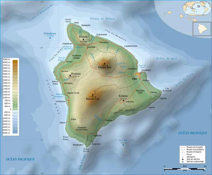
Français : Travail personnel.
Sources :
Logiciels utilisés :
Autres données :
English: Personal work.
Sources:
Software used:
Other Details:
|
||||||||
| Sortzailea | |||||||||
| Georeferencing | If inappropriate please set warp_status = skip to hide. | ||||||||
| Beste bertsioak | |||||||||
| Aitortu (required by the license) | © Sémhur / Wikimedia Commons / | ||||||||
| Assessments |
|
||||||||
| SVG | W3C-validity not checked. Fitxategi hau (bektore-irudia) hau Inkscape-ekin sortu da .
.
|
||||||||
| Graphic Lab |


| Kameraren kokapena | | Irudi hau eta gehiago beraien kokapenekin hurrengo lekuetan: OpenStreetMap |
|---|
Lizentzia
| Copyleft: This work of art is free; you can redistribute it and/or modify it according to terms of the Free Art License. You will find a specimen of this license on the Copyleft Attitude site as well as on other sites. |
- Askea zara:
- partekatzeko – lana kopiatzeko, banatzeko eta bidaltzeko
- birnahasteko – lana moldatzeko
- Ondorengo baldintzen pean:
- eskuduntza – Egiletza behar bezala aitortu behar duzu, lizentzia ikusteko esteka gehitu, eta ea aldaketak egin diren aipatu. Era egokian egin behar duzu hori guztia, baina inola ere ez egileak zure lana edo zure erabilera babesten duela irudikatuz.
- berdin partekatu – Lan honetan oinarrituta edo aldatuta berria eraikitzen baduzu, emaitza lana hau bezalako lizentzia batekin argitaratu behar duzu.
Fitxategiaren historia
Data/orduan klik egin fitxategiak orduan zuen itxura ikusteko.
| Data/Ordua | Iruditxoa | Neurriak | Erabiltzailea | Iruzkina | |
|---|---|---|---|---|---|
| oraingoa | 14:24, 16 otsaila 2009 | | 3.110 × 2.563 (2,11 MB) | Sémhur | Valid SVG |
| 19:31, 7 maiatza 2008 |  | 3.110 × 2.563 (2,19 MB) | Sémhur | Route coupée trop courte, je rallonge. | |
| 19:57, 2 maiatza 2008 |  | 3.110 × 2.563 (2,18 MB) | Sémhur | Suppression d'une partie d'une route détruite par une coulée de lave | |
| 12:37, 1 maiatza 2008 |  | 3.110 × 2.563 (2,18 MB) | Sémhur | New version, with vectorized shaded relief | |
| 20:35, 29 apirila 2008 |  | 3.110 × 2.563 (1.017 KB) | Sting | Slight correction | |
| 20:11, 29 apirila 2008 |  | 3.110 × 2.563 (1.017 KB) | Sting | Added legend | |
| 18:01, 22 apirila 2008 |  | 3.110 × 2.563 (1.012 KB) | Sémhur | Espacement de lettres (oubli) | |
| 10:45, 19 apirila 2008 |  | 3.110 × 2.563 (1.011 KB) | Sémhur | Correction de l'altitude du Mauna Loa et espacement de lettres | |
| 21:04, 17 apirila 2008 |  | 3.110 × 2.563 (995 KB) | Sémhur | Correction d'un problème avec le relief | |
| 20:47, 17 apirila 2008 |  | 3.110 × 2.563 (996 KB) | Sémhur | == Description == {{Information |Description= {{en| Topographic Map in french of the island of Hawaii.}} {{fr| Carte topographique de l'île de Hawaii.}} |Source=Travail personnel. {{clr}} Sources : * Fond de carte : |
Irudira dakarten loturak
Hurrengo orrialdeek dute fitxategi honetarako lotura:
Fitxategiaren erabilera orokorra
Hurrengo beste wikiek fitxategi hau darabilte:
- af.wikipedia.org proiektuan duen erabilera
- ar.wikipedia.org proiektuan duen erabilera
- bn.wikipedia.org proiektuan duen erabilera
- crh.wikipedia.org proiektuan duen erabilera
- cv.wikipedia.org proiektuan duen erabilera
- en.wikipedia.org proiektuan duen erabilera
- eo.wikipedia.org proiektuan duen erabilera
- es.wikipedia.org proiektuan duen erabilera
- fr.wikipedia.org proiektuan duen erabilera
- Analogique
- Mauna Kea
- Mauna Loa
- Utilisateur:Sémhur
- Hawaï (île)
- Hualālai
- Discussion aide:Cartographie
- Discussion Wikipédia:Wikiconcours/mars 2008/Équipes/Équipe 5
- Projet:Impression/Wikigraphistes
- Utilisateur:Sémhur/Récompenses
- Wikipédia:Image du jour/juin 2010
- Wikipédia:Image du jour/16 juin 2010
- Kohala (volcan)
- Cap Kumukahi
- Phare du cap Kumukahi
- Discussion Wikipédia:Atelier graphique/Archive 10
- fr.wikinews.org proiektuan duen erabilera
- hu.wikipedia.org proiektuan duen erabilera
- id.wikipedia.org proiektuan duen erabilera
- it.wikipedia.org proiektuan duen erabilera
- ko.wikipedia.org proiektuan duen erabilera
- krc.wikipedia.org proiektuan duen erabilera
- lbe.wikipedia.org proiektuan duen erabilera
- lv.wikipedia.org proiektuan duen erabilera
- mg.wikipedia.org proiektuan duen erabilera
- mk.wikipedia.org proiektuan duen erabilera
- mt.wikipedia.org proiektuan duen erabilera
- oc.wikipedia.org proiektuan duen erabilera
Ikus fitxategi honen erabilpen global gehiago.